The Convicts of Port Arthur

As part of the government’s 19th century plan to rid Britain of its less desirable and criminal population, convicted criminals were transported to one of a number of penal colonies.

Following the American War of Independence Britain no longer had the option of sending its convicts to America. So from 1788, forced transportation meant incarceration in the Australian colonies. For many that meant doing time at Port Arthur.

Port Arthur Historic Site

Trivial crimes by the standards of today, stealing a loaf of bread to feed a starving child could lead to a prison sentence. Often the offenders were from the slums of the big cities with theft being their only means of survival. With Britain’s prisons overflowing, convicted criminals, regardless of their offence, often found themselves facing transportation to the new convict colonies in Australia. Men, women and even children discovered this was mostly a one way journey. Few ever returned home.

Severe as the sailing across the oceans was, the convicts were to face far worse once they arrived in Australia. Hard labour in harsh conditions, mosquitoes, leeches, disease, floggings, solitary confinement and being shackled often for more than a year with heavy leg-irons that could only be removed by hammer and chisel. New arrivals were given the most punishing and strenuous work as ‘Tree-getters’ and dockyard workers in an attempt to break them and conform to the colony’s strict regulations.

Port Arthur Historic Site

Named after Governor George Arthur in 1830 and conceived as a penal station, Port Arthur began as a timber production centre using convict labour. Timber mills were constructed to process the logs that were being felled by ‘tree-getters’ for use in government projects. By 1833, however, Port Arthur had become a punishment centre for repeat offenders from around the Australian colonies.

Discipline by punishment, training and education was designed to rehabilitate the convicts but, as today, while some went on to live productive, skilled and peaceful lives many continued to reoffend and often spent time committed to solitary confinement in cells only just large enough for a hammock.

Confinement Cells

Education led to useful skills such as clothes, shoe, furniture and brick making as well as masonry to produce stone for the church and prison buildings, while the more trusted worked at the Dockyard boat building. More than seventy convicts worked in the dockyard mostly as unskilled labour under the direction of skilled civilian shipwrights. Often they would be working neck-deep in cold water. In total the convicts produced around 150 small open-top boats and 16 large-decked ships between 1834 and 1848.
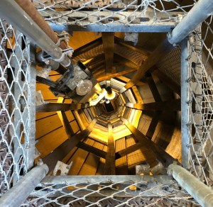
The Treadmill

To feed the growing population of Port Arthur a water-powered flour mill and granary was constructed in 1842. It included a giant treadmill large enough for 56 convicts to operate at once. The treadmill was both a form of providing energy for turning the grind stones in the flour mill but also as punishment by hard and repetitive labour. It wasn’t unusual for a convict to misplace a foot on the treadmill, which usually resulted in mutilation of a limb. Bad as that was, further punishment was often inflicted for not returning to work the next day. A flogging carried out by another convict was a common punishment.

Getting water to the flour mill was troublesome. Evaporation and leakage of the aqueduct and millrace and regular lack of rain meant operation of the mill was far less successful than anticipated and eventually it was used only intermittently.

Port Arthur Penitentiary

By 1849 over 2,000 people including convicts, civilian staff and soldiers were based at Port Arthur. However, with the cessation of transportation in 1853, fewer transportees were arriving, instead, being a secondary punishment station, sentenced men from within the convict penal colonies were sent to Port Arthur further increasing the population to almost 3,500. Although large tracts of land had been turned over for cultivation as well as cattle and sheep being reared for meat in an attempt to be self sufficient, the station was still heavily dependent on supplies from the capital, Hobart.

Solitary Confinement

By the late 1840’s the authorities realised that harsh punishment just made the convicts tougher. It was a convict sign of defiance that no cries of pain were made during floggings even when close to death. So an even more savage form of punishment was introduced – Solitary Confinement and for those still unmanageable there was the ‘Dark Cell’ where the prisoner was kept in total darkness and silence for up to 30-days.

The Separate Prison

In a belief that psychological punishment was more effective, the Separate Prison was built where convicts were isolated from each other and held in total silence. The only time they were permitted to speak or communicate in any form was when questioned by prison guards or to the visiting clergyman. When out of their cells they wore hoods with just slits for their eyes so they were unable to recognise each other. Any breach of the prison rules meant time spent in the Dark Cell.

The isolation broke many men, either mentally destroyed, permanently withdrawn or psychotic and so an asylum was built to house them and other ‘lunatics’ from the other colonies.

In 1857, to cope with the increasing convict population, the granary and flour mill were converted into a penitentiary with workshops, a blacksmith and a steam-powered sawmill added. The lower floor of the building housed 136 confinement cells. On the ground floor men were constrained by heavy leg-irons weighing up to 13kg, while those on the first floor wore lighter irons. And on the uppermost floor bunks we’re constructed for 348 men.

No escaping the Dog Line

About 20km north of Port Arthur the Tasman Peninsula narrows to an isthmus just 100-metres wide known as Eaglehawk Neck. In the early part of the 1830’s, Governor Arthur stationed sentries at the Neck to prevent escapees reaching the mainland of Tasmania. One of the stationed officers suggested placing nine dogs with lamps across the isthmus, not to attack escapees but to alert the sentries of suspicious noise or activity that the sentries could not hear above the noise of the sea. Mostly successful, the number of dogs was further increased to eleven when platforms for the dogs were placed in the sea to prevent any convict’s attempt to wade around the line.

The Dog Line at Eaglehawk Neck

The Dog Line was a good deterrent, as was the rumour spread by the officers that the sea was infested by sharks, and it remained in place until Port Arthur was permanently closed.

Isle of the Dead

Situated within view of the colony is a small, tree covered island and the burial site of more than 1,100 people who died at the colony between 1833 and 1877. It’s more than a challenge to dig a grave in the island’s rocky ground and you have to wonder how so many remains were able to be buried here.

Distinction between the civilian staff, military and convicts continued even in death with the convicts being buried on the lowest ground of the island.

Closure

The settlement was finally closed in 1877 with the buildings and land auctioned-off to private buyers and a change from the name of Port Arthur to Carnarvon.

In all, 76,000 convicts were transported to Australia and held in colonies in Western Australia, Victoria, New South Wales and Tasmania.

Early Tourism

Very quickly after the closure and sale of the colony, curious tourists began to visit the site and by the 1920’s several of the convict buildings had been converted to museums. Recognising the importance of the convict history of Australia the Tasmanian state government began acquiring portions of the site from private owners and restored the Port Arthur name. Today more than 30-buildings, gardens and extensive ruins form the Port Arthur Historic Site and its importance to Australian history was recognised when in July 2010 the site was added to UNESCO’s World Heritage List.

What we see now, and the defining feature of the Port Arthur Historic Site, is the remains of the penitentiary building gutted by fire in 1897. Just the masonry and the metal bars across the windows survived the heat of the blaze. Many other buildings were also destroyed in the fire including the church, which was attended by up-to 1,100 convicts for the compulsory services held each Sunday.

Surviving Penitentiary Window

There is so much more to Port Arthur and it’s convict history and a wealth of information is presented on display in the Visitor Centre and the small museum in the ‘Separate Prison’ building. And, of course, through online resources. However one issue we found in both the visitor centre and prison building was the very low light level and highly reflective copper panels carrying all the descriptive text. We gave up trying to read them.

A lone Gunman

Of course no account of Port Arthur is complete without mentioning the dreadful events of April 28th 1996 when a lone gunman, armed with two semi-automatic rifles, shot dead 35 innocent people and injured 23 others. Twenty of those killed were in and adjacent to the Broad Arrow Cafe at Port Arthur Historic Site. In the coach park the gunman continued shooting and killing including two children aged just three and six years.

The gunman, 29-year old Martin Bryant, remains in Risden Prison near Hobart serving concurrent life sentences for each person he murdered with no parole and an additional life sentence for the remaining 36 charges, which included 20 attempted murders.

The Broad Arrow Cafe was later dismantled leaving only the walls to form part of the memorial to those who tragically lost their lives. Such was the public and political outrage that strict new laws governing gun ownership were introduced. The Port Arthur massacre followed just six-weeks after a similar shooting in the Scottish town of Dunblane where 18 people were killed. Changes to gun ownership laws in the UK were introduced the following year.

Bruny Island

Just 20-minutes by ferry from the Tasmanian mainland, Bruny Island is a wild and remote place with white sand beaches, turquoise water, magnificent sea cliffs and abundant wildlife. The island is marketed as a foodies paradise – so where’s the food?

Artisans

We had been greatly looking forward to our visit here following numerous TV travel and food shows highlighting the artisan cheese makers, bread bakers, wine makers, beer brewers, the artists, the writers and, of course, the unspoilt natural landscape. That list, however, didn’t include the tarmac road builders – much of the island’s roads are dirt roads, dusty when dry and muddy when wet.

The Neck

The island is split into two – the North and South Islands are linked by a very narrow isthmus known as the Bruny Island Neck. The majority of accommodation and activities are located on the South Island, which includes our caravan site at Adventure Bay.

Truganini Lookout

Giving views of both the north and south islands as well the Tasmanian mainland, Truganini Lookout sits above the middle of Bruny Island Neck. Reached by 279 timber steps, the lookout is named after the Aboriginal woman Truganini (1812-1876) reportedly the last full-blooded aboriginal person to die in Tasmania. Believing she was the last of her pure race, she once declared, ‘I know that when I die the Museum wants my body’.

Prior to her death in Hobart, Truganini pleaded to the authorities for a respectful burial and asked that her ashes be scattered in the D’Entrecasteaux Channel, a region of great significance to her people, fearing that her body would be mutilated for scientific purposes just as her late husband had been.

Contrary to her request she was buried at the old female penitentiary. Her remains were later exhumed by the Royal Society of Tasmania, which was authorised by the government to take possession of her skeleton. However, it was on condition that her remains were not to be exposed to public view but ‘decently deposited in a secure resting place accessible by special permission to scientific men for scientific purposes’.

Truganini Lookout

Despite Truganini’s wishes and in violation of the government’s conditions, her remains were displayed in the Museum of Tasmania from 1904 to 1947. It wasn’t until 1974 that her wishes were finally honoured and her cremated remains were scattered in the D’Entrecasteaux Channel.

Her story is a sad one and highlights just how appallingly the Europeans treated the Aboriginal people of lunawanna-alonnah (Bruny Island). In memory of Truganini and the Nuenonne speaking people of the southeast, a cast bronze memorial was placed at the top of the lookout with a 360-degree view of what was rightfully their land.

Adventure Bay

To the east and south of the Neck is the sweeping Adventure Bay. It has more than a few connections with the famous early explorers and first off is Abel Tasman who first sighted the bay in 1642 and tried to make land in his ship the Heemskerck. Abel’s ship was driven back by an offshore storm but in memory of his attempted landing, Abel named the bay ‘Storm Bay’. In 1773 Captain Tobias Furneaux anchored in the bay for five days and took the opportunity to rename the bay ‘Adventure Bay’ after the name of his ship HMS Adventure. Furneaux had been sailing alongside Captain Cook’s ship, HMS Resolution on Cook’s second voyage in search of The Great Southern Land – Australia, when he became separated from Cook. Furneaux noted the bay was ideal for resupplying ships with fresh water, fish and timber from the giant gum trees.

In 1777 Cook, in his ship Resolution, stopped to take on fresh water and eleven years later the infamous Captain Bligh* moored in the bay to resupply HMS Bounty. Having survived the famed mutiny on the Bounty, Bligh once again stopped in 1792 to resupply his latest ship HMS Providence. And in 1798 Matthew Flinders tried without success to enter the bay in his ship ‘Norfolk’.

Taking advantage of the largely sheltered bay, Europeans soon began to arrive and setup several whaling stations and sawmills forming a fledgling timber industry.

Two Tree Point – George Tobin 1792

Two Tree Point, which sits within Adventure bay, is still a source of fresh water and was used by Cook, Bligh and Furneaux to replenish their water supplies. Using the name of Cook’s ship, Bligh named the water source ‘Resolution Creek’. It is believed the two large eucalyptus trees that can be seen today are the same trees sighted in the late 1700’s and in a painting by Bligh’s 1792 Expedition’s Principal Artist, Lieutenant George Tobin.

Two Tree Point – Resolution Creek

Today Adventure Bay is a quiet tourist destination with access to several walks within South Bruny National Park, a well stocked general store, the Bligh Museum detailing Bligh’s association with the bay and Mary Bruny Cafe for a good coffee and great food.

Cheese and Beer

One of the few foodie retailers and artisans can be found at the Bruny Island Cheese Co. and Bruny Island Beer Co. both located at Great Bay. We tried the cheese tasting plate with three cheeses served with fresh crusty sourdough bread baked on-site and a delicious relish. Each cheese is hand made in the traditional way from the milk of their own cows in Huonville.

  • O.D.O. – a simple curd cheese that is just One Day Old
  • 1792 – a pungent washed rind aged on Huon pine – strong and smoky
  • SAINT – a mild white mould cheese, our favourite

We didn’t try the beer tasting plate – it was tempting but we were still driving.

Bruny Island Chocolate Co.

Hidden behind a dense line of trees on Main Road at Alonnah, Bruny Island Chocolate Co. is a curious place. Hand made chocolates and fudge apparently made on-site but with no sign of any manufacturing, no tasting options and a clear preference to upsell by putting chocolates in decorated metal boxes and lining nearly every available shelf. By all appearances it is just a shop. We did buy a few covered bars and later discovered none of them were labeled.

And there’s More

There is a winery, a whisky distillery and the restaurant called Get Shucked on Bruny Island for those with a taste for Oysters. But we were expecting more for somewhere classed as a ‘foodies paradise’.


* The HMS Bounty was categorised by the Admiralty as a ‘Cutter’, the smallest form of warship, and as such it did not require the full rank of a post-Captain. Instead the ship and her crew were commanded by a Lieutenant, the only commissioned officer onboard, which meant Bligh was not the Captain of the Bounty as is often quoted. His conspirator and leader of the mutiny was acting-Lieutenant Fletcher Christian.

The ‘Cutter’ class of warship also did not require the usual attachment of Royal Marines whose role was to maintain order, a fact that Mr Christian clearly took advantage of.

Tahune Adventures AirWalk

Imagine walking among some of the tallest trees on earth, not at ground level but in the lower canopy high above the forest floor – and still straining to see the top of the trees. That is exactly what you can do at Tahune Adventure’s AirWalk deep in the Southern Tasmanian Wilderness.

Among the Ancient Giants

Tahune Adventures AirWalk

Tahune Adventures is surrounded by the southern hemisphere’s tallest forests and one of the few places where the famous ancient Huon pines and giant Mountain Ash trees grow together. Unlike the Mountain Ash the Huon Pine requires a permanent source of water and is more usually found near rivers as is the case here, and, appropriately, it is the Huon River.

Walking the Walk

The AirWalk is a 600-metre elevated walkway 30-metres above the mosses and bracken of the forest floor and high among the trees giving close-up views of Myrtle and Leatherwood and the trunks of the giant Mountain Ash. The AirWalk culminates in a cantilevered platform 50-metres above the Huon River.

AirWalk Cantilever

Far more sturdy than you would expect, the walkway gives excellent views of the confluence of the Huon and Picton rivers as well as the number of ancient trees gathered along the river banks swept downstream during successive flood events.

Forest Fire

Something unfortunate, however, makes this place quite unique and that is the effect of a major fire that took place in 2019. Much of the ground cover was destroyed through to the Huon River and a number of the giants seriously damaged, some later felled for safety. This means the view of the trees and surrounds are far less obscured and new growth, in all shades of green, can be clearly seen.

Fallen Giant

The AirWalk received some damage during the fire and, along with several of the walks around the area, access was restricted for many months while safety inspections took place. The only sign of damage now visible is the charred bark of many of the trees contrasting with the recently replanted landscaping around the visitor centre and the 104-steps leading to the start of the AirWalk.

Swinging Bridge

In addition to the AirWalk two additional walks allow exploration of the forest. The Huon Pine Walk gives the opportunity to see, touch and smell these ancient trees along the short 20-minute loop. The 3km Swinging Bridges Walk offers more of a challenge. Rope bridges here provide a safe but swinging crossing of both the Huon and Picton rivers. Far less stable than the AirWalk platform it is only a few metres above each of the rivers.

And there’s more

There are two additional activities here; River Rafting and the Eagle Hang Gliding experience that glides 400-metres from the treetops across the Huon river. No experience is required – the hang glider is suspended by wire similar to a flying fox ride.

Drive with care

Being in the wilderness it is not too surprising that this location is quite remote. Access is via a sealed but winding road and a 30-minute drive from Geeveston, the nearest town. This is a logging road and great care should be taken when logging trucks are active.

For more information including booking details check the Tahune Adventures website.

The Taroona Shot Tower

An unusually tall stone tower, built in 1870, sits beside the Channel Highway at Taroona 12km south of Hobart. It’s purpose is not obvious. Is it a smoke stack for some Victorian industrial scale boiler, a fire watch tower, perhaps, or an old lighthouse watching over ships entering Hobart Harbour?

Taroona Shot Tower

It’s a Machine

It’s actually a Shot Tower, a machine of sorts, built to produce the lead shot fired from muskets. By any imagination the tower is not the first thing you would think of as being a machine of any design but innovation leads to success and that was certainly the case for Scots born Joseph Moir, Engineer, Architect, Carpenter and Overseer.

Once the tallest building in Australia, the tallest in Tasmania (until 1960) and believed still to be the tallest circular sandstone tower in the world, Taroona Shot Tower was built in just 8-months by two stonemasons to Moir’s design.

Standing almost 59-metres tall, 10-metres in diameter at the base and narrowing to 3.9-metres at the top, the tower’s impressive dimensions are deceptive. The adjoined stone building, which gives access to the shot tower, looks diminutive by comparison but is actually a substantial building in its own right. It’s only when standing within the tower that its true size can really be appreciated. Looking upward is more than a little daunting. Lining the walls of the tower is a circular wooden staircase comprising 318 shallow steps with a platform every 180-degrees and on some levels an open slot gives views of the increasing loftiness of the climb.

A long way to the top!

At the top of the tower, the original chimney pot has been removed and the roof made weather-tight. An external, circular metal platform and railing has been added providing excellent views of the Derwent River and surrounding countryside – at least to those brave enough!

Lookout below

Sitting to one side is the wood-fired cauldron originally used to melt a combination of lead, antimony and arsenic. Once molten the metal would have been poured into a steel colander suspended over the centre of the tower. Droplets of metal would begin to form and cascade down the length of the tower creating perfectly round spheres before hitting a tank of water at the base and cooling. The process took a lot of experimentation to perfect but finally produced successful shot on the 8th of September 1870 and continued to do so until 1905 when it was no longer commercially viable.

A long way down!

The size of the shot produced could be controlled to some extent by altering the size of the holes in the colander but it was not a perfect process. The size of the droplets varied with each pour requiring manual retrieval from the water tank and sorting the tiny shot in poor light by hand.

A Victorian tea shop first opened in the late 1800’s is still operating at the base of the tower. Each day they bake the lightest scones you’ll have ever eaten served with your choice of over 70-types of tea. They are among the best we have tasted throughout our travels around Australia and come very highly recommended.

Land of the Giants

You just can’t get enough of tall trees in this part of the world. If your neck has recovered from craning skywards after visiting the majestic tall trees in The Tarkine and Mount Field National Park, prepare yourself for the real giants here at Styx Tall Trees Conservation Area.

Finally Protected from Felling… for now

A long and bitter campaign by the Wilderness Society and Greenpeace to stop the continued felling of native trees within the conservation area was, thankfully, successful and in 2013 part of the Styx valley, where the largest and most ancient trees still grow, was added to the Tasmanian Wilderness World Heritage Area. However, successive Tasmanian governments have worked hard to reverse this hard fought protection for the benefit, not of mankind but the forestry industry.

Not ‘coincidentally’ the government agency ‘Forestry Tasmania’, trying to show its new, environmentally friendly concern for the ancient forests, has renamed itself ‘Sustainable Timber Tasmania’.

The ‘Bigger Tree’ – Tasmanian Mountain Ash

Remote Access

There are several walks within Styx Tall Trees Conservation area – none of them too challenging, but getting here we’d recommend a 4-WD or a car that you don’t mind receiving a few scratches here and there, possible punctures, wrecked shock-absorbers and a good coating of mud.

The turn-off from Gordon River Road leads to the 18km stretch of Styx Road, which is unsealed, winding and with plenty of potholes to navigate, as are possible fallen trees. Although Tasmania Parks & Wildlife Service does make regular inspections the road is actually maintained by the logging companies.

It should be noted that this is a remote location and there is no mobile phone reception. So be prepared in case of an emergency, leave a note to inform someone of your planned walk and expected return time and carry a snake/spider bite kit.

Styx Tall Trees Walk

The start of this walk is close to the signpost announcing you have arrived in the Big Tree Forest Reserve. A small area suitable for parking is available and gives the easiest access to see the ‘Big Trees’.

Eucalyptus regnans – 90-metres and still growing

A 1km loop over mostly flat ground. A partial board walk takes you past an enormous felled giant Mountain Ash tree (Eucalyptus regnans) covered in moss, as are most of the trees on this walk. The Mountain ash is the largest flowering plant in the world and by a long way – some exceeding 90-metres in height, a girth in excess of 20-metres and some more than 500-years old.

You will find some of the largest trees on this walk around the halfway point. Among them are two in particular, one named ‘The Big Tree’, being the tallest measured at that time but was later followed by one even taller and aptly named ‘The Bigger Tree’.

Lion’s Mane Fungi – Hericium Erinaceus

Among the decaying timber and ground cover of moss are many varieties of fungi and well worth a closer look as you follow the walk among ancient tree ferns. Keep an eye out too for several of the older trees that have some unusual fungi growing from them such as the Lion’s Mane mushroom.

Record Breakers

There is one tree further south, known as Centurion, that has reached the lofty height of 100.5-metres and continues to grow. It is the third tallest tree in the world and the tallest known hardwood tree on earth. It’s exact location has been kept quiet to protect it from trampling feet. Exceeded only by the giant Redwood Trees of the Californian coast of North America at 116-metres, the Mountain Ash is the tallest species of tree in the Southern Hemisphere.

Hygrocybe pseudograminicolor

Styx River Walk

Originally named ‘Sticks River’ by early settlers due to the jumble of fallen trees and branches obscuring views of the river, it was renamed ‘Styx River’ during an 1826-28 period of formalising names by the government.

The Styx River walk, though pleasant, is among less dense and less ancient growth leading down to the tumbling Styx River. Although several large Mountain Ash trees are visible on the track they are less impressive if you have already taken the Tall Trees Walk and less accessible to photograph. There is, however, a good undercover of Myrtle and tree ferns. It is a much drier walk underfoot but suitable footwear is still advisable, especially when wet.

Cortinarius metallicus

The Chapel Tree

Not the easiest Tree to find. The Chapel Tree is accessed 4km further along Styx Road from the Tall Trees Reserve where you then need to take a right turn and continue for a further kilometre to a fork in the road. Take the right fork and continue along the narrowing track for a final kilometre. From here look for a handmade sign pointing into the bush where a barely visible track leads. Follow the pink tape markers through bracken, low hanging branches and boulders placed among wetter patches and you’ll arrive at the Chapel Tree.

What makes this giant unique is the enormous base of the trunk. Years of decay has created an open cavity inside the trunk large enough, apparently, to hold fifteen people. It’s a brave person that stands inside the trunk of such an enormous tree knowing what is left of the tree’s decaying base is supporting such a staggering weight. But, of course, in the name of science adventure, I took a quick look.

The Chapel Tree

Hopefully being a little more remote, the Chapel Tree will be less visited and continue to grow for many, many more years.

If you are ever in this part of the Tasmanian Wilderness, this is a must visit to see some of the tallest trees in the world in their unspoilt habitat. Just don’t be off put by the few kilometres of destroyed forest that has been clear-felled as you drive along Styx Road into the Styx Valley.