Yesterday we were exploring among the forests of the Tarkine but there’s more to the region and there could not be a greater contrast.
The Wild West
A substantial section of the west facing northwest coast is within the Tarkine boundary and offers just as much drama as the forests to the east.
Couta Rocks
Couta Rocks
Nothing quite prepares you for the wild and dramatic view as you climb above the dunes a few hundred metres north of the beach shacks at Couta Rocks. Crashing waves add even more drama to the windswept beach. Many of the rocks are razor-sharp and brittle so care is needed navigating your way among them.
Following the clearly defined path we rounded the dunes to be greeted by a sweeping bay with scattered driftwood, seaweed and a few poisonous Bluebottle jellyfish. Someone had built a beach shelter nearby held together with kelp seaweed but probably not the best protection from the squalls and gusting winds blowing in from the Indian Ocean. But the weather does lend itself to photography as long as you can stand your ground against the wind.
Access to Couta Rocks is along a rutted gravel road but, taken carefully among the potholes, most vehicles will have no trouble reaching the sea.
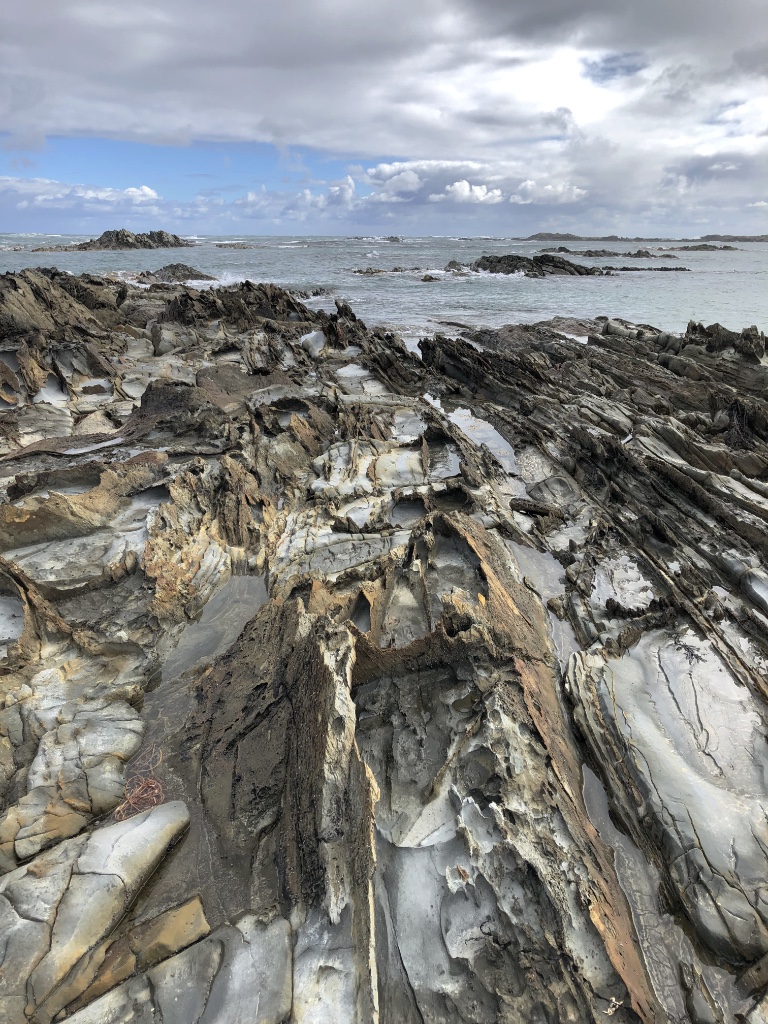
Nelson Bay
A little further north along the C214 – Temma Road is Nelson Bay. Again access by a gravel road should cause no issue for smaller 2-wheel drive vehicles but leave the caravan behind. The road terminates at a small gathering of homes overlooking the wild sea with plenty of flat ground to park. A short stroll south leads to a path to the beach and again wild seas are crashing over the rocks further out in the bay. Here erosion has created curious formations with jagged rocks standing upright and certainly capable of severe injury if you were to fall awkwardly.
Nelson Bay
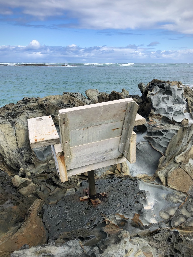
It’s the kind of place you could spend hours staring out to sea, if you hadn’t frozen by then, and coincidentally someone has conveniently mounted a chair right among the rocks so you may do just that. On a calm day this would be a great place to chill but on our visit further rain was racing in from the sea and it was time to take cover.
A chair with a view
Tomorrow we retrace our steps back to the north coast but we’ll miss the tranquility the Tarkine has given us over the past few days. We’ll always remember with great affection what a very special place in the world this is.
The greatest expanse of cool temperate rainforest in Australia and the second largest in the world, the Tarkine is a massive wilderness region covering much of the northwest of Tasmania.
Wet and Wild
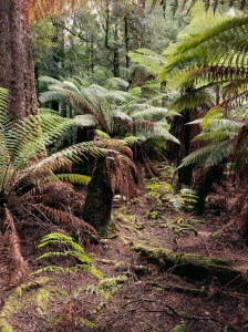
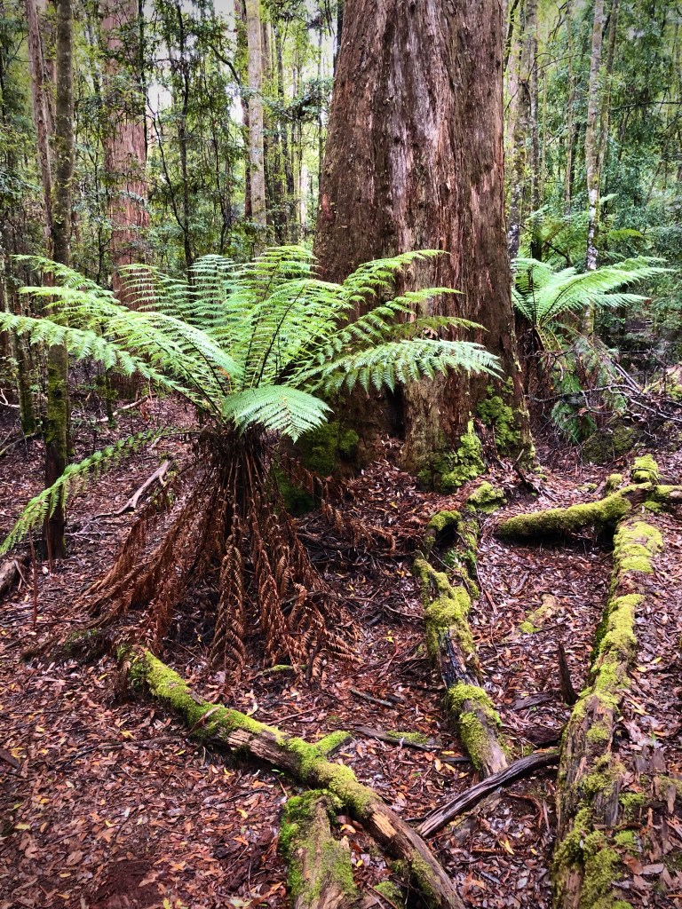
Walking through the rainforest on a damp, showery day is like walking back in time through some mythical ancient forest. And it is with good reason, the Tarkine is a rare remnant of Gondwana, a true and ancient wilderness. It is a land of tree ferns, lichens, mosses, fungi, rare and ancient trees and abundant wildlife including the endangered Tasmanian Devil.
Tarkine Tree Ferns
Our visit followed the Tarkine Drive, which takes a circular route through the northwest of the region. Largely black-top ‘C’ grade roads but giving way to gravel tracks to visit many of the highlights. All are passable in sturdy two and four-wheel drive vehicles but there are numerous potholes to navigate.
Trowutta Arch State Reserve
Our first stop was at Trowutta Arch State Reserve and what an amazing walk this was with an unexpected and startling view of the arch. The relatively* easy 30-minute return walk takes you among giant Myrtle Beech trees as well as Leatherwood, Sassafras and Celery-topped pine trees, while in the undergrowth tree ferns, native laurel, brackens, fungi, bright green mosses and algae create a dense forest floor.
Every now and then we spotted what appeared to be white leaves laying on the forest floor and were puzzled where they came from. We later discovered, thanks to a very knowledgeable Park Ranger, that they were flower petals from the famous Leatherwood tree. And it is a tree full of surprises. Very slow growing and only 10-20 metres tall, the Leatherwood tree doesn’t flower until it is at least 70-years old and doesn’t reach it’s peak until 120-200 years of age. Leatherwood is the most common form of honey in Tasmania and accounting for nearly 75% of production. It has a strong and intense floral taste and is easily recognisable among other native honeys. Not surprisingly the Tarkine is one of the major regions beehives are placed during the flowering season between spring and summer. We were lucky to still find Leatherwoods flowering in early autumn.
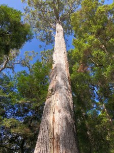
Giant Myrtle Beech tree
It’s impossible to walk past one of the Myrtle Beech trees without straining your neck and gazing upwards to the crown. They are absolutely straight and void of limbs until reaching the canopy tens of metres above the forest floor. It’s easy to see why loggers were keen to exploit these ancient trees. Thankfully now we are more concerned about the environment and majestic trees such as these are left to grow old gracefully. However, that may not always be the case.
A valuable resource
Unbelievably the Tarkine is not adequately protected with the Tasmanian government seeing this region as a resource to be exploited for timber production and mining. That is despite expert recommendations, commissioned by the government, that it should be protected from any further development. The only way to guarantee this wilderness is preserved for future generations, and for the sake of the wildlife that live there, is to get the whole area under World Heritage listing status. This is a growing, and angry, voice campaigning to protect the Tarkine. Let us hope they succeed.
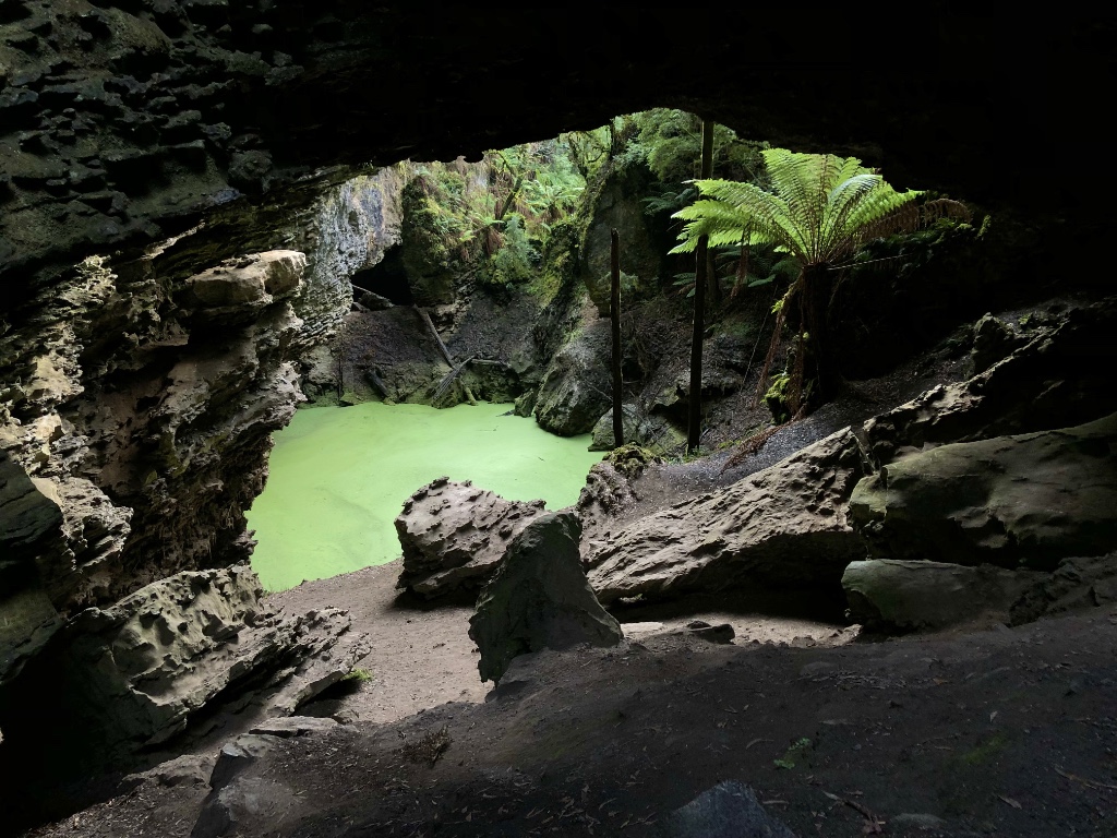
Trowutta Arch
No assuming you haven’t tripped over one of the many tree roots or falling backwards trying to see the top of the Myrtle trees, you will soon, and suddenly, come across a dark, gloomy hole in a cliff face. But right in the middle is a large, luminous green soup of algae surrounded by fallen rocks and tree ferns. It is spectacular, otherworldly even. I try not to look at the photos in guide books – it spoils the surprise, but I could not even begin to imagine this scene. It has been the highlight of our trip to Tasmania… so far.
Morons
Sadly there are those who enjoy such beautifulscenery as this that they feel a desperate urge to deface it with graffiti or scrape their name into the rock. Here it is more evident than any landmark we have seen in all our travels around Australia. Why do such mindless morons do this? Not only is this action illegal, no one but themselves are the slightest bit interested in seeing someone else’s name. Maybe they should remember that they can easily be traced – they gave their details when buying a Parks Pass after all – duh! … assuming they bought one.
Watch out – a Sinkhole!
Much of the region lays on top of a limestone plateau from aeons past when the Tarkine was underwater. Common to many areas around the south of Australia, acidic erosion creates underground caverns and often these collapse over thousands of years to form sinkholes. The Tarkine is not a immune to this form of erosion and many sinkholes have formed. Some are just shallow depressions but several have filled with water supporting a wide range of aquatic life. One such sinkhole sits right beside the road between Rapid River and the Milkshake Hills. Drive to fast and you’ll miss it. It’s well worth stopping to take a look but don’t step too close to the water – the ground is very soft.
Julius River
From the car park there are two walks, the shorter being just a 20-minute circular route beside the Julius River. This path begins on an excellent raised walkway with viewing platforms as you follow the river before dropping to a bush walk. Here you may see Platypus if you’re lucky.
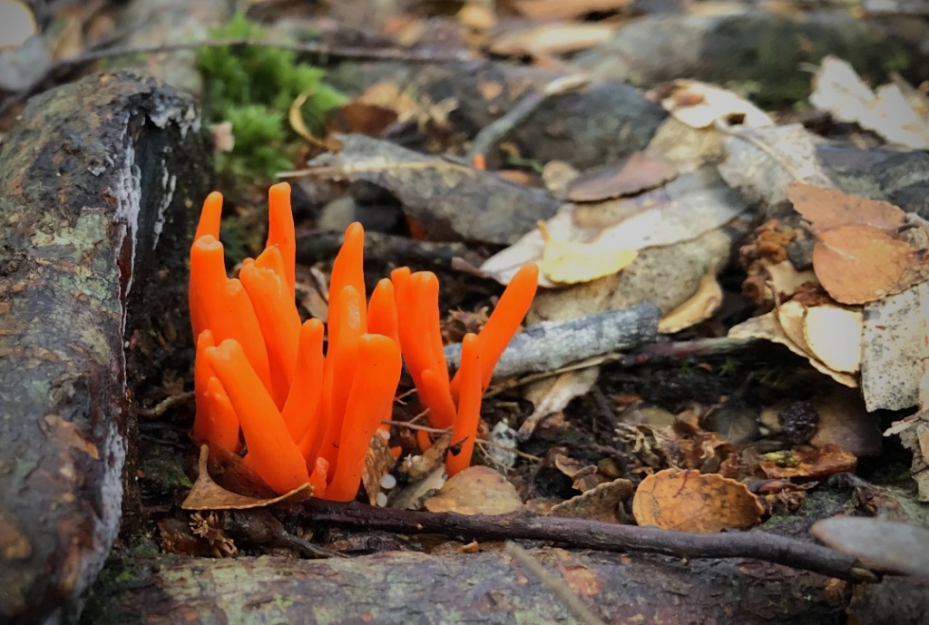
Coral Fungi – Clavulinopsis sulcata
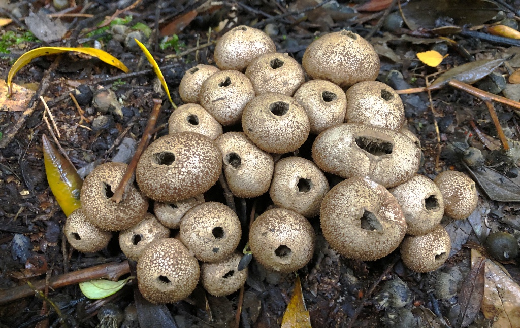
The trees along the walk are hanging with old man’s beard and there are a multitude of algae and parasitic ferns thriving on decaying branches. Also common during the autumn are a wide range of fungi, many brightly coloured and standing out among the fallen leaves and twigs and others such as puff balls arranged in small piles.
Puff balls – Lycoperdon pyriforme
Further along the walk the ascent becomes steep and the parks Service have built a series of very sturdy but narrow steps. These aren’t for those unsteady on their feet or those with a fear of heights. Beware, there are no handrails on most of the steps on this walk. There were plans to add handrails but apparently the parks service had reached the limit of their budget.
At this point the track becomes harder to follow but if you look carefully you’re see some red markers to the left on a tree and subsequent white-topped posts beside several small depressions will guide you to an old downhill track to the car park. But not before one final series of exposed downward steps, which some may find challenging without a handrail.
Sumac Lookout
Our final stop in the Tarkine was at Sumac Lookout. You can’t miss it – there’s a very large ground level sign carved-out with a chainsaw. A small parking area leads to a short stroll to the lookout point high above the Arthur River and an amazing view it offers in all but heavy rain. We were lucky the showers had eased and the sun was trying to break through.
Arthur River from Sumac Lookout
We had thoroughly enjoyed the day exploring this beautiful unspoilt region of northwest Tasmania, exceeding everything we had expected by a long margin. It had been a cold, blustery day but the weather just added to the atmosphere. This was the Tasmania we had really hoped to see and we were amply rewarded.
* A large part of the walk is among tree roots, which are a trip hazard as well as slippery when wet.
We’ve been experiencing some of Tasmania’s wild and windy weather over the past few days but that was not going to stop us exploring the northwest of Tasmania and all it has to offer those adventurous enough to brave the inclement weather.
Totally Wild
Today we headed 56km inland to see a big tree, actually The Big Tree, and Dip Falls both situated within the stunning Dip River Forest Reserve and the 450,000 hectares cool temperate rainforest known as the Tarkine. It’s a remote place and visually spectacular with large tree ferns and mosses lining the narrow road. It’s not hard to imagine dinosaurs still roaming around.
Upper Dip Falls
Sadly the signboard at Dip Falls had been vandalised by some idiot who must have thought it helpful to melt a hole in the perspex protective screen and fill it with gravel. Fortunately it’s very easy to see where the path leads and there are two choices. The easiest route to the falls crosses the road bridge where you can see the river disappear below, and a short level stroll to an observation platform overlooking the upper falls.
Lower Dip Falls
For the more adventurous, and sure footed, you can take the route into the forest direct from the car park and climb down the very well constructed staircase to the first platform, which gives a good view of the upper falls backed by gum trees partly obscured by drifting mist. Continuing further, the weaving steps drop to a platform extending over the Falls River with the most amazing view of the upper and lower falls as they cascade over the dark hexagonal basalt columns. It is worth every one of the 214-steps down and the same up to return to the car park.
An absolute must see during your visit to the northwest of Tasmania and all the better during the cool, damp weather as we visited.
Tasmania has some of the oldest forests in the world populated by some of the planet’s tallest trees.
Just a short drive from Dip Falls is the car park for the Big Tree. And there’s not just one big tree but many that you’ll find hard to miss right beside the car park. These majestic, Royal even, trees are of a species known as Eucalyptus regnans, from Latin meaning ‘to reign’ but more commonly known as Mountain Ash or a less inviting Swamp Gum.
Tree ferns and Mountain Ash
Surrounded by tree ferns, mosses and lichen covered tree trunks, the short path leads past several impressive but smaller ‘Big Trees’ until it reaches The Big Tree. And it is big, very big! Standing almost 100-metres tall and a girth to match at nearly 17-metres. Sadly this 400-year old specimen is reaching the end of its life and is slowly decaying.
The Big Tree
A Fight for survival
How this stand of trees survived the relentless logging of the 19th and early 20th century is remarkable and owes its survival to its remoteness and difficulty of access. However that may change. Unbelievably 90% of the Tarkine is not protected and under real threat from logging, mining and damage by off-road vehicles. Worryingly the Tasmanian government sees the Tarkine as a resource to be exploited despite the region’s considerable Aboriginal heritage and being one of the last intact wilderness areas in the world.
The only way to guarantee these magnificent trees and the wilderness of the Tarkine survive intact is to get listed as a World Heritage Site – a process that an increasing voice is demanding.