Whitsundays Cruise

Our final pre-booked trip sees us cruise around the Whitsundays onboard SeaLink’s Reef Quest III, a new and fast, powered catamaran. SeaLink provide courtesy coach transfers from several pickup points in and around the Airlie Beach area for the short drive to Shute Harbour, around 10-minutes from central Airlie Beach.

Whitehaven Big Island Day Tour

Our choice of cruise with SeaLink is the ‘Whitehaven Big Island Day Tour’ taking in North and South Molle Islands, Cid Island and Hook Island, which we saw from the air yesterday but this time cruising through the narrow Hook Passage before taking anchor at Tongue Point. From there we transfer to the beach aboard the ship’s tender to walk up to the Hill Inlet viewpoints before sailing around to Whitehaven Beach for a bush-walk or to pass a couple of hours wandering along the 7KM beach before returning back to port via Chance Bay, Hamilton and Dent Islands.

First impressions

Stepping aboard Reef Quest immediately impresses with two large, immaculate and brightly lit indoor cabins with plenty of outdoor seating also available for those who enjoy the cool sea breeze or keeping a lookout for wildlife. Tea and coffee facilities greet you in the air conditioned dining cabin with large viewing windows and comfortable banket seating.

SeaLink’s Reef Quest III

All aboard

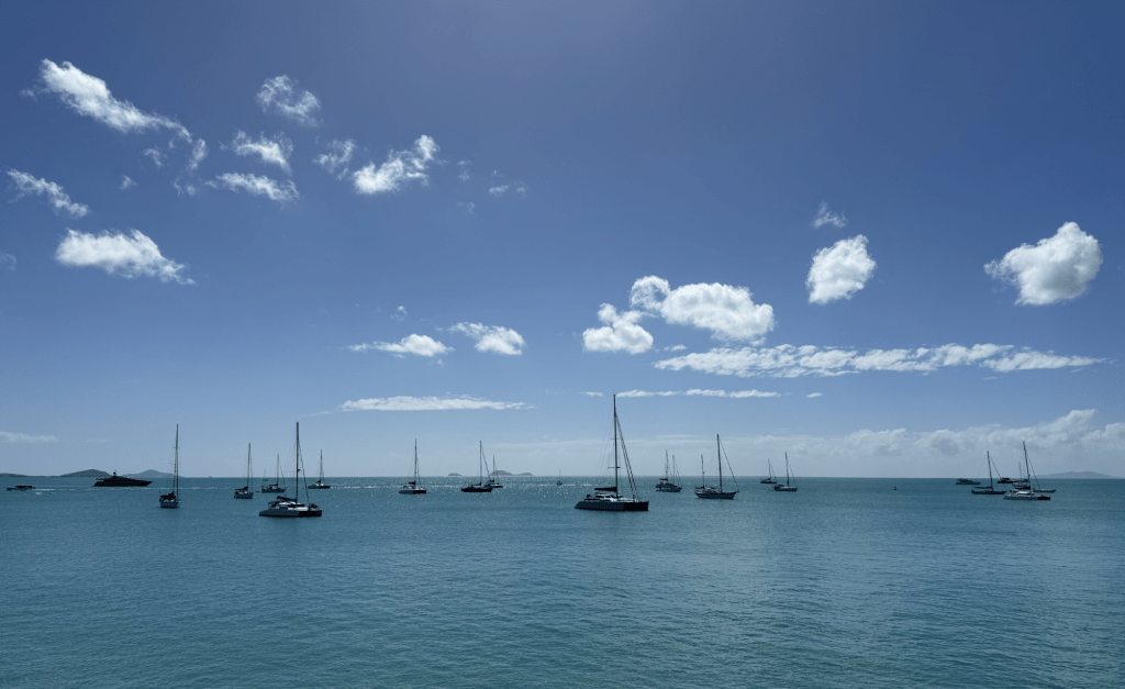
We’re soon underway with the morning snack of fresh fruit and muffins being served. The ship can carry 280 guests but limiting each cruise to only 84 means there is no problem finding a seat or waiting too long to be transferred by tender at each landing.

SeaLink Whitehaven Big Island Day Tour route

Our skipper was also our guide while onboard and ran a commentary throughout most of the cruise detailing the history of the Whitsundays and facts about each of the islands as we passed them. He also kept an eye out from his high vantage point for whales and it wasn’t long before we started sighting them. Perhaps not quite as close as you would see on a dedicated whale watching tour but very visible and on several occasions very active breaching high in the air and creating a huge splash as they dropped to the sea. Giving maximum viewing time the skipper slowed right down to give everyone the opportunity to take a photograph or ‘oooh’ and ‘aah’ each time a whale launched itself into the air.

Humpback Whale breaching

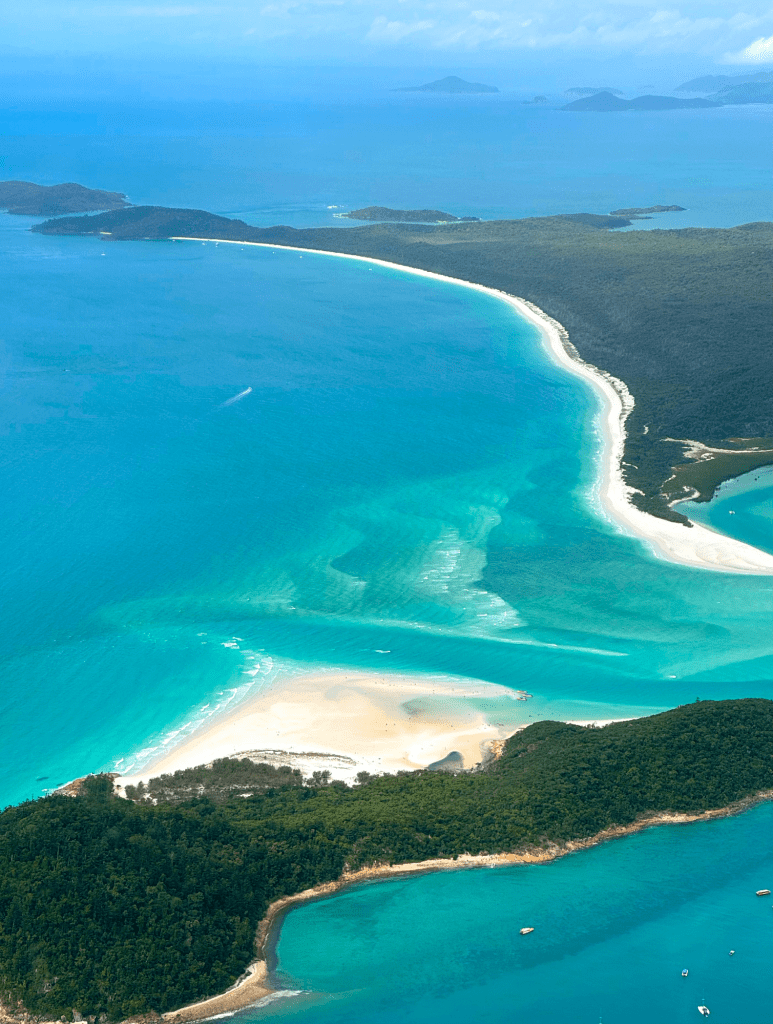
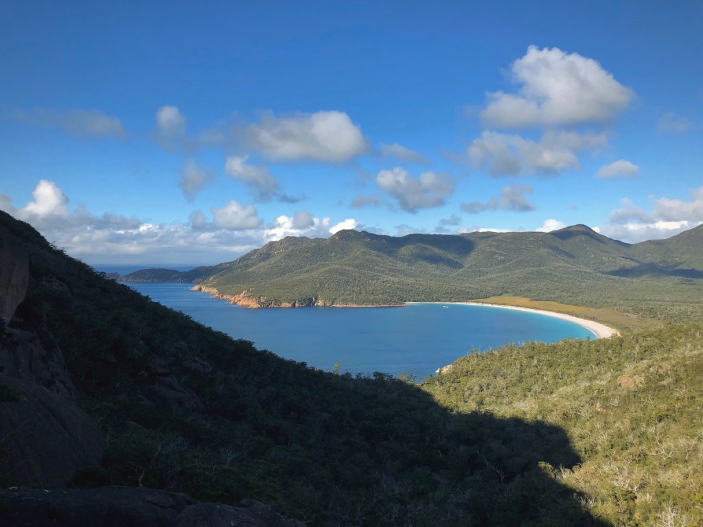
Back on course and speeding towards Hook Passage it was very noticeable that the sea was beginning to churn with waves forming as the tide was being squeezed between the adjacent islands. Next, turning to the south and we’re into clear water again passing along the coast of Whitsunday Island heading for anchorage just to the north of the spectacle that is Hill Inlet. Yesterday we got stunning views of Hill Inlet from our flight above but today was our opportunity to view the swirling sand and sea formation from a vantage point with our feet firmly on solid ground.

Tongue Point to Hill Inlet

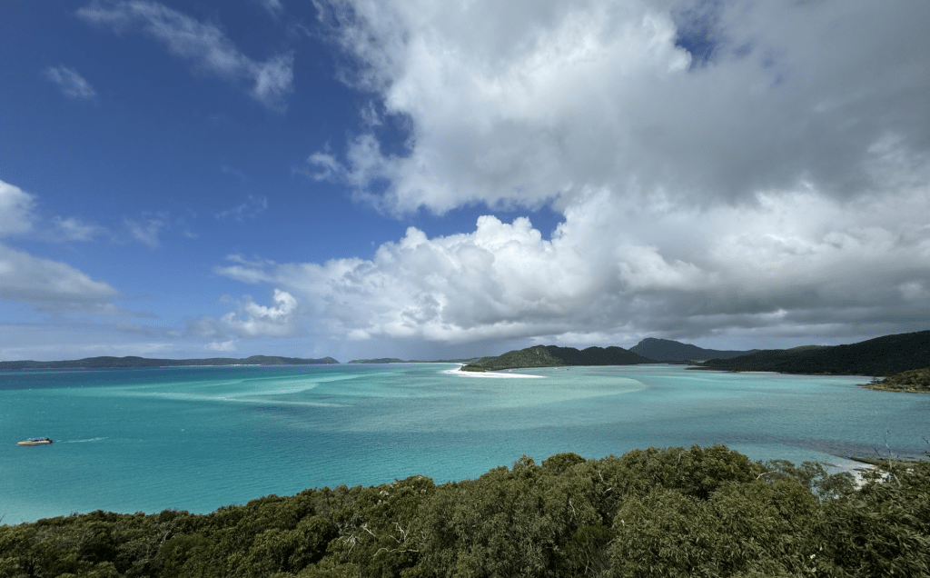
Our boat set anchor in a sheltered bay at Tongue Point to transfer passengers to shore ready for the bush walk up to the Hill Inlet viewpoints. It’s a relatively easy walk with many well built steps to negotiate as it passes through native vegetation and small trees. Brief glimpses of the sea tease before reaching the summit and then a short decent before opening out to the first of three viewing platforms. And what a view! Although quite busy with our three groups amongst others, it was easy to get to the front of each platform. It wasn’t the best weather for photographs today with rain in the distance and low, patchy cloud but the scene was still stunning with the swirling and twisting Hill Inlet passage making its way further into the Island’s interior. Created by the ever changing tides, the wavy patterns are constantly changing with the best views to be had at low tide. To the left of the passage, and continuing into the distance, is the famous Whitehaven beach, which we will be stepping onto next.

As the three groups began their walk back to the beach, I stayed on a little longer when I noticed a gap starting to open up in the cloud shading the inlet. It was well worth the wait to see the sea light up in such a stunning shade of turquoise. It could only have been better if the tide was a little lower.

Before long we were being ferried back to our boat and enjoying a delicious buffet lunch the crew had laid out for us while we continued around to Whitehaven Beach.

Hill Inlet from Tongue Point Lookout

Whitehaven Beach

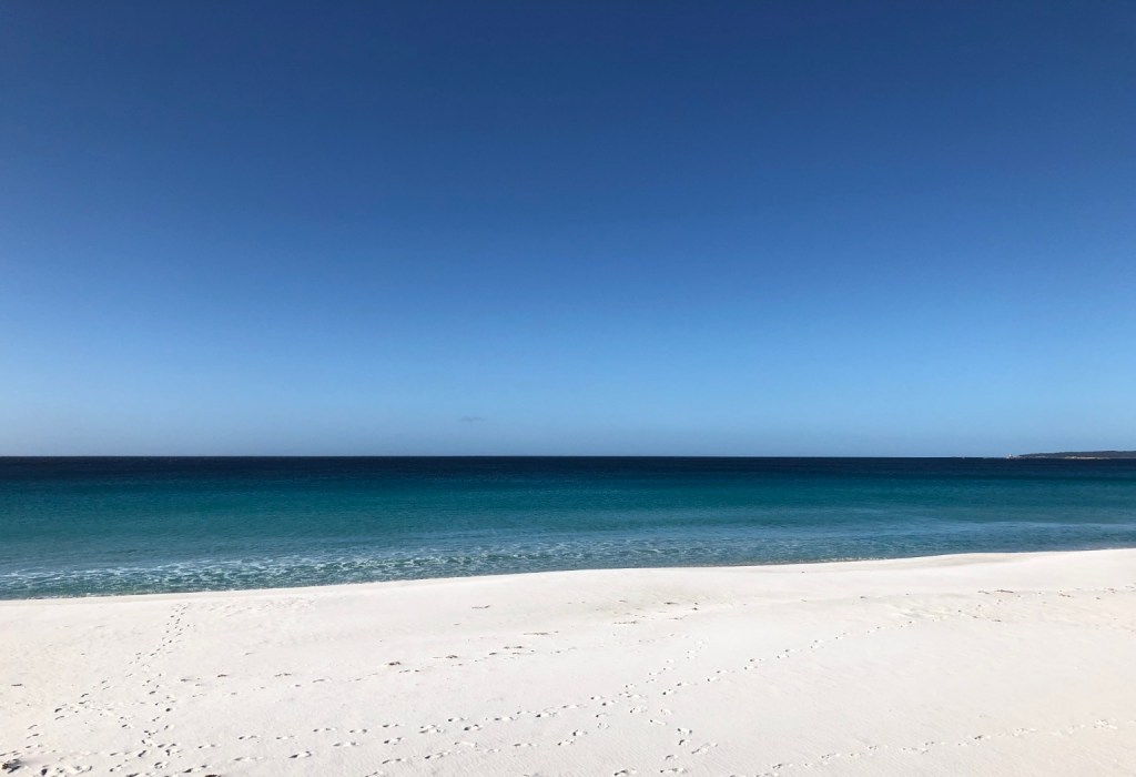
Our ship’s tender ferried us to the beach giving us two hours to wander, take a guided bush walk or just laze around in the sun. We chose to walk along the almost deserted beach and paddle in the surprisingly cool water for a kilometre or so before sitting under the shade of a tree and watching the waves lap gently against the shore. The beach sand has a few unusual characteristics; being almost white allows it to reflect away most of the intense sun meaning it’s actually cool to walk on and even squeaks as you do so. It is also extremely fine and, apparently, makes an ideal polish for jewellery. I’m sure our feet felt softer after our walk too. Local myth even suggests NASA took advantage of the silica’s purity using it to create glass for the Hubble Space Telescope. When questioned if the story was actually true, allegedly the response was, “um, we may have done.” That’s a ‘No’ then.

Whitehaven’s 98% pure silica beach really is quite special, though, and something of a quandary. Sand is usually deposited on shore from local sources such as finely broken down rock, coral or sea shells. Here, however, there is no known source of silica of such high grade anywhere nearby. It is believed to have been deposited here potentially millions of years ago and is such an important and irreplaceable asset that it is legally protected with heavy fines for anyone attempting to take home a ‘souvenir’ of their visit. That is, of course, unless you are Oprah Winfrey, who’s advisers clearly didn’t make her aware of the rules.

The beach does, however, have a claim to fame being regularly voted best beach in the world and was featured in the ‘Pirates of the Caribbean – Dead men tell no tales’ feature film. Prior to, and during, filming the production company bought every available day trip and boating adventure in the area to ensure the beach was free of tourists and the sea clear of any boat that didn’t fit the era. And just to add to the authenticity of the ‘Caribbean Island’ it was standing-in for, the production crew planted palm trees along the beach, which natively do not grow on the island. After production ended they were removed and replanted at Airlie Beach.

Wildlife

There is plenty of wildlife around the Whitsunday Islands both on land and in the sea. Snakes such as pythons and grass snakes are common but there’s also the highly venomous eastern brown and taipan, though mostly found around properties or sunbathing on the roads. Dugongs, countless reef fish and six of the seven species of turtle in the world call the Whitsundays home and not forgetting the migrating whales, white and blacktip reef sharks, manta rays and several species of dolphin. Of course being in the Australian tropics means stinging jellyfish, some of which can be lethal, should be avoided during their most active time between October and May – probably not the best time of year to go swimming. And I suppose I should mention the common ‘handbag’, known also as the saltwater crocodile, is present in these waters. Usually confined to rivers and river estuaries they do often wander further afield in search of a decent meal. But for us, apart from the odd spider and sea birds, all we saw was a friendly Lace Monitor scavenging for food.

Australian Lace Monitor

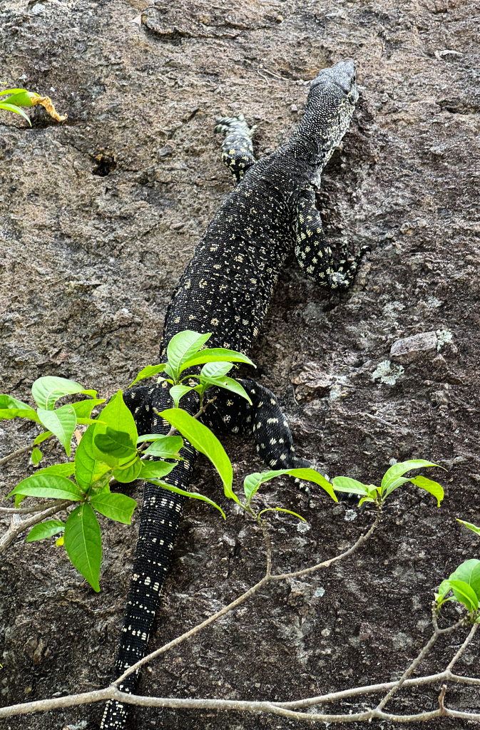
The lace monitor is both active and highly agile being just as happy walking along the ground or climbing up rock faces or trees in search of a tasty morsel… and growing up to two metres in length, big enough to scare the life out of an unsuspecting tourist!

Heading for Home

Back onboard we settled in for the return leg of our cruise passing between Whitsunday and Haslewood Islands to follow the southern coast of Whitsunday Island through Chance Bay admiring some exclusive properties. We skirted Hamilton Island, home to a few eye wateringly expensive resorts such as the hyper-exclusive, 6-star ‘qualia’ resort – deliberately written with a lowercase ‘Q’ and a registered name to boot – now that’s exclusive! Well, Chris Hemsworth, Taylor Swift and Johnny Depp must think so being just a few of the celebrities that have stayed there.

Finally passing by Dent, Henning and Long Islands we arrived back at Shute Harbour after a thoroughly enjoyable day, made all the more special by good friends of ours who we have been sharing this week of adventures with in and around Airlie Beach.

A Grand Day Out

We’d highly recommend SeaLink’s ‘Whitehaven Big Island Day Tour’ suitable for all ages with the added opportunity to see whales during July to October and at the very least some magnificent scenery.

More details available from SeaLink’s website.

Heart Reef

Our second day at Airlie Beach and it is an extra special one as we take to the air flying over two famous landmarks and the possibility of sighting whales.

Wasabi

Flying from Whitsunday Airport, just 8-minutes from Airlie Beach, our flying adventure is onboard the Australian designed and built GippsAero GA8 Airvan delightfully named ‘Wasabi’. Unlike commercial passenger planes, Wasabi is designed for short flights with maximum visibility for those onboard. Little legroom, noisy, a low ceiling and certainly no reclining seats on these flights but that just adds to the experience of the real sensation of flying in small aircraft – turbulence and all. As with all aircraft, though, safety is the priority and our pilot Sam took us through the emergency procedures including wearing and operating our life jackets as we were to fly over water.

Our aircraft – the eight-seater ‘Wasabi’

Turbulence

It should be noted that the location of the airfield in a narrow valley is known to experience strong and gusty winds and that was certainly the case as we took-off and made our first turn. It soon settled, though, as we headed out over water with great views along the coast to Airlie Beach and the islands that make up the Whitsundays.

Scenic flight route through the Whitsundays

We were soon flying past Daydream Island and south along the tip of Long Island with the largest of the islands, Whitsunday, to our left. Then passing over Hamilton Island known amongst others riches for the famous Hamilton Island Race Week, which attracts ‘yachties ’ and spectators from all over the world. Next was one of the main sights we were looking forward to on this trip, Hill Inlet, surely amongst the most spectacular views in Australia if not the world. The weather wasn’t quite on our side, though, with some low cloud and rain in the distance but it was expected to clear further off the coast.

Hill Inlet from 2000ft with Hamilton Island just beyond

Throughout the flight Sam gave us a comprehensive commentary about the European’s first discovery of the Whitsundays and the Ngaro people’s 9,000-year history of the region. The Ngaro, also known as the ‘Canoe people’, travelled between the islands using sturdy canoes made from lengths of Ironbark timber held together by fibrous roots. In addition to the myriad forms of tropical reef fish calling the waters of the Whitsundays home, sharks, manta rays, stingrays, dolphins, migrating humpback whales and Dugongs* can also be sighted. The dugongs take advantage of the sea grasses that grow around the islands and protected marine parks.

Whitehaven Beach

A very popular day trip from Airlie Beach is the 7KM long Whitehaven Beach. Known for its 98% pure silica bead sand, which has the advantage of staying cool even on hot sunny days and so fine it can be used as a polish.

The sweeping Whitehaven Beach

It can get busy at times and especially during peak season when multiple day trips coincide. However, with such a long beach it’s easy to find a patch of your own to just sit and watch the gentle lapping waves and remind yourself what a magnificent place you are experiencing.

Whales!

Our flight continued further out to sea and we were now spotting numerous humpback whales breaching and ‘fin slapping’, several appearing to be mother and newborns. It wasn’t that long ago that the hunting of whales had reduced the humpback population to the low hundreds. Now protected, recent observations show a dramatic increase and it is now believed 30-40,000 humpbacks populate the migration route between the Antarctic and far north Queensland.

Over the Reef

Five minutes later, just as the sun appeared through light cloud, we were flying over the inner reef and dropping to 500ft tracking the most stunning coral formations surrounded by clear turquoise-blue water.

The inner Great Barrier Reef

Then came a countdown from Sam with cameras ready as we were about to fly low over our target – the perfectly descriptive Heart Reef. First sighted in the 1980’s the reef has become the emblem of the Whitsundays and is now probably the most photographed coral formation in the world. And finally, there it was.

Heart Reef

Not wanting to miss getting the photograph during our fleeting path over the reef I opted to record video and grabbed the best frame. To ensure passengers on both sides of the plane got a good view Sam did a second pass in the opposite direction.

Climbing once again we headed back to the airport spotting further migrating whales along the way. Final approach to the runway presents just as much of a challenge as takeoff and sitting right behind our pilot it was clear just how much counteracting the gusty wind was required to bring the plane safely onto the runway.

A fantastic trip and scenery we will never forget. The highlight of our trip… so far.

For more information and booking options, checkout Ocean Rafting Scenic Flights

*Also known as Sea Cows or Manatees in other countries.

Airlie Beach – The Whitsundays

Famous as the yachting home of the Whitsunday Islands in Tropical North Queensland, its turquoise water, pure white beaches and its proximity to the Great Barrier Reef.

Airlie Beach and the Whitsundays has been on our bucket list for many years and we’re finally here. It is everything we believed it to be and much, much more.

Hill Inlet tidal patterns

Why so Blue?

The water around the Whitsundays is the most beautiful shade of blue bordering on turquoise and glistens in the intense sun. Although stunning it’s not, as you would expect, crystal clear. In fact it’s positively murky. It is by no coincidence that the sea here is the same shade of blue as a glacial lake and for the very same reason. Glacial water owes its colour to the crushed, powdery rock particles suspended in the water and reflects the light that falls upon it in all directions. In the case of the Whitsundays it is near pure silica that sits suspended giving it a milky look but which has even greater reflective properties.

Pioneer Bay – Airlie Beach

A little error in history

Captain James Cook sailed through the Whitsunday Islands in 1770 naming the route between the islands as the Whitsunday Passage and one of the islands in the group Pentecost Island. His journey through the islands was made during the feast of Pentecost, which is traditionally the seventh Sunday (50th day) after Easter. The passage was named after Whit Sunday, meaning ‘White Sunday’ referring to the white gowns worn during the feast of Pentecost. However… on the day Cook named the passage he mistakenly believed it was the Sunday known in the Christian calendar as Whit Sunday when it was in fact a Monday. The Mondays or the Monday Islands just wouldn’t have quite the same ring to it.

Activity Central

Once a small timber, sugar cane and fishing town, Airlie Beach soon became popular as a major Queensland tourist destination. Sugar cane is still a major crop in the region and grown all year round, but Airlie is now the centre for the many active leisure pursuits available to visitors whether on land, sea or in the air. Bushwalking, sailing, kayaking, jet skiing, small boat cruising, body boarding, wind surfing, skydiving and scenic flights are all available for the adventurous. And for those that prefer to soak up the sun the stunning Whitehaven Beach is just a boat ride away.

Day Trippin’

We pre-booked three trips knowing we would be at the mercy of the weather but being peak season we wanted to make sure we got a place on each adventure. First off was a Sunset Cruise on the twin masted, timber hulled ‘Gentleman’s Ketch’ the Lady Enid. Built in 1961 she has competed in five Sydney to Hobart races as well as fifteen Brisbane to Gladstone challenges and was first across the line in the inaugural Sydney to Brisbane Race in 1964.

Lady Enid – Airlie Beach

High winds had delayed the Lady Enid’s return from its daytime cruise, which meant our sunset cruise was late setting sail. It was worth the wait, though, and not just for the included cocktail and antipasto platter as we cruised in near silence with just a single sail set. It wasn’t long, though, before the cool sea breeze sent a reminder that a warm, windproof jacket is very much recommended.

Sunset Cruise onboard Lady Enid

The sunset didn’t disappoint, though, as it passed behind the mountains while creating some beautiful golden reflections on the rippling water. Due to the late departure our return to the harbour was completed in darkness but our skipper did a great job of navigating around the moored boats in the outer harbour and performed a perfect ‘reverse park’ back at the marina.

Lady Enid runs four different tours in and around the Whitsundays and is also available for charter hire. More information and booking details available here: IconicWhitsunday.com.au

Tomorrow we take to the skies and head out to the Great Barrier Reef.

Bay of Fires

Situated on the Northeast coast of Tasmania and stretching from Eddystone Point to Binalong Bay, the Bay of Fires is a stunning mix of turquoise water, powdery white beaches and orange tinted granite boulders.

Named by British Captain Tobias Furneaux* in 1773 after observing fires lit by aboriginal people along the coast. Furneaux’s ship, HMS Adventure, was sailing as part of Captain Cook’s second exploration of the pacific before becoming separated.

Bring on the Colour

The orange colour is caused by lichen** from the Hymeneliaceae family. It is a common occurrence on the granite rocks and boulders in the northeast of Tasmania, but is particularly vibrant within the Bay of Fires region.

Lichen coated boulders – Bay of Fires
The Gardens – Bay of Fires

Parking is limited along the Bay of Fires coastline with the largest parking area situated at The Gardens. There are small areas where you can pull-off the narrow road but we’d recommend getting there early.

For photography, the early morning and late evening light is best when the orange lichen appears to glow.

Binalong Bay

The powdery white beach between The Gardens and Binalong is perfect for a gentle walk. Humpback Whales can be spotted here from May to July as they head north to warmer waters and again between September and November when they return south to the Antarctic.

Turquoise waters of Binalong Bay

*Tobias Furneaux was one of the first men to circumnavigate the world in both directions.

** Lichens are a combination of algae and fungus that live in a symbiotic relationship. The algae gathers energy from the sun by photosynthesis providing food for the fungus, while the fungus creates a protective environment for the algae to thrive.

The Hazards of Freycinet

Located within Freycinet National Park, The Hazards are a mountain range on Tasmania’s east coast and gateway to one of the most famous beaches in the world.

Beauty in Pink

Anyone touring around Tasmania, and with the remotest interest in geology, will notice a change in the mountains on the Freycinet peninsula from the grey granite, black basalt, dolerite and sandstone of much of the state’s mountainous regions. As you approach the Hazards via Coles Bay you cannot help but notice their very distinct pink hue and more so in the evening under the setting sun.

Setting sun on the Hazards

Long, long Ago

The granite mountains, believed to have been named after African-American Whaler Captain Richard Hazard, are comprised of a mineral called Orthoclase – a pink form of feldspar that owes its colour to another mineral, iron.

The Hazards from Coles Bay

Around 60-million years ago volcanic activity beneath what is now Tasmania, pushed magma upward lifting the land hundreds of metres above sea level creating the Freycinet peninsula. During the same period the land to the west of the peninsula sank forming Great Oyster Bay. As the magma slowly cooled under pressure the Orthoclase formed into the large rectangular crystals that are typical of the rock, granite.

Over the following millions of years the softer ground above the granite eroded away exposing the rock to weathering by ice, rain and wind that has resulted in the giant rounded boulders that now litter the mountains. Today the Hazards stand at a shadow of their former height but still reach an impressive 485-metres above the sea.

Freycinet National Park

Much of the Freycinet peninsula falls within the bounds of Freycinet National Park* with the only access being via a single narrow, and not very well maintained road. Credit, though, is due for the excellent, and unusually large, National Park Visitor Centre, where a large number of park guides and leaflets about the region and activities can be found as well as a good selection of books, outdoor clothing, local crafts and souvenirs.

The distant Hazards Range from Swansea

Time for a Walk

We had been looking forward to exlploring the Freycinet region again following a previous visit in 2008. On that occasion the weather wasn’t in our favour with light rain and low cloud setting in just as we got to a major viewpoint. This time, however, the sun was shining and the sky was mostly clear, perfect walking weather despite the cool late autumn wind.

Our walk was the shortest within the park but with a view worth every step, and ache, up the often steep climb. In 2008 the same track between Mount Amos and Mount Mayson was best described as ‘rough’ with a steep climb on a slippery gravel path interspersed with sharp rocks ideal for tripping the unwary. Now, however, sturdy steps have evened out the steeper sections making the upward path easier, though still requiring a fair amount of effort. Several ‘new’ viewpoints have also been added looking back over Coles Bay towards the distant coastal town of Swansea.

Wine Glass Bay from the Lookout

The higher you climb the larger the giant granite boulders become and in places you are walking among and between them towering over you. But there is a very worthy reward for the 45-minute climb when you reach the top of the pass – for this is the Wine Glass Bay Lookout Walk and from here, as the name suggests, you get the most amazing view of the world famous Wine Glass Bay. All the effort to arrive at the lookout weighed down by a heavy camera bag was worth every step. The lookout, too, had been updated with additional platforms giving greater access to the increasing number of walkers being attracted to the peninsula.

1,000 Steps Too Many

We had considered the extended walk that leads down to the white sand of Wine Glass Bay’s beach but we had second thoughts after reading more about the terrain. Access to the beach requires navigating a far steeper track and includes around 1,000 steps down and back to return to the viewpoint. At the end of the day it is just another of the many beautiful white beaches with turquoise water along the east coast of Tasmania and its ‘fame’ due to its curved shape and remote seclusion. So, after several photographs and a chat with a couple of fellow travellers, we headed back down the quite unique one-way track, which separates the freshly rested from the newly exhausted heading uphill.

People often ask, ‘what is the origin of the bay’s name?’, and no one is quite certain. The most preferred, and most pushed by marketeers, relates to the similarity of the bay’s shape to that of a wine glass, but there is a darker and more likely offering, a bloody one, which is where our whaling Captain Richard Hazard features once again.

In the early 1800’s whaling was a significant contributor to Tasmania’s fortunes and much of that was along the east coast of the state. Whaling stations were a common site where spotters would take to the high ground looking for the migrating whales, sending out the boats to harpoon any unfortunate passing whale and dragging them back to the shore-based stations for ‘processing’. The whale’s baleen was used to stiffen corsets and the rings of the fashionable British ladies’ dresses, while whale oil, extracted from the blubber powered the dim lights in Victorian houses and an extremely fine oil for lubricating clocks, watches and the machines driving the booming Industrial Revolution.

A Bloody Past

The more likely origin of Wine Glass Bay’s name, however, is related to the colour of the deeply blood stained water and beach during the whaling season rather than the shape of the bay. Imagine too the putrid stench of boiling blubber and the rotting carcass’s of whales. There could not be a greater contrast to how the pristine bay appears today.


*As with all National parks in Tasmania, a National Parks Pass is required for vehicles entering Freycinet National Park. Passes are available from all National Parks Visitor Centres in Tasmania as well as from the automated machines in Freycinet National Park’s car parks.