If you should find yourself one day driving south along George Gray Drive coastal road towards Northampton in Western Australia, you could be forgiven for thinking you have caught a flash of pink in the corner of your eye, a flock of Flamingos feeding in a lagoon perhaps. Well you wouldn’t be too far off the mark as I’ll attempt to explain.
Pink Lake Lookout
Hutt Lagoon, next to the small township of Gregory, is a salt lake created by a sand dune barrier separating the lagoon from the sea water of the Indian Ocean. Laying just below sea level, gravity allows sea water to seep into the lagoon where evaporation is the only way out and in the process leaving behind significant salt deposits. Rain water during the wet season helps keeps the salinity level in check.
Dunaliella Salina
The colour of the lagoon comes from a microscopic form of green algae known as Dunaliella salina, which has the ability to create high levels of beta carotene – a common and natural red food colouring, an antioxidant and source of vitamin A.
No Flamingos here
It is believed the colour helps protect the algae from the extreme ultra-violet radiation that is typical of the areas that the algae thrives. The quantity of beta carotene is at its highest during the spring and summer months when the UV radiation is at its most elevated causing the lagoon to take on a pink or reddish hue.
Hutt Lagoon supports commercial operations including the world’s largest microalgae production plant using artificial ponds to grow the algae for the food and cosmetics industry and Brine Shrimp farming for the fish, prawn and aquarium trade. Still want to use that red lipstick?
And the flamingos?
Beta carotene is the colour creating agent found naturally in crustacean, which includes shrimp and prawn – among the flamingos natural diet. It is added to food pellets given to captive flamingos in zoos around much of the world. It is also the reason the shell of crustacean turn red when cooked.
Salt encrusted rocks
Depending on the time of day the best photographic point is either at the Pink Lake Lookout on the road to Gregory, or from the top of the hill just beyond the lookout. Just a few hundred metres further on and looking northwards, the lagoon is more easily accessible along a short path leading to the water’s edge where rocks in the shallow water are heavily encrusted with salt.
Hutt Lagoon creates an amazing spectacle for landscape photography and well worth a detour from the North West Coastal Highway.
Photo Tip:
Use of a circular polarising filter is recommended to reduce reflections on the lagoon. It also helps saturate the colour of the pink water and blue sky to more accurately capture what the eye sees.
Situated on the Indian Ocean coast 485KM north of Perth, Kalbarri National Park is a diverse arid region with magnificent ocean cliffs, inland gorges and the Murchison River that flows into the sea at the small seaside town of Kalbarri.
Driving south on the Northwest Coastal Highway from our last camp at Denham delivered an unexpected surprise. Mulga scrub and acacia spread out over flat sandy plains with spring flowers lining the roadside gradually gives way to larger shrubs, and Spotted River Gums. The surrounding landscape starts to undulate with winding roads and then, all of a sudden, cresting a hill, there is a total and unexpected change of scenery. Gone are the Mulga plains and dense bush, the wild flowers and trees. We have suddenly arrived in the rolling hills of the Wheatbelt. It’s almost like a summer scene in England with golden fields ready for harvesting. Quite surreal.
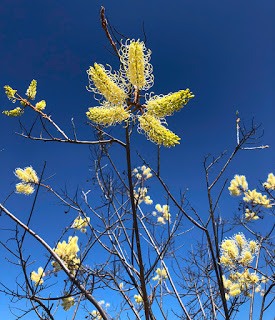
White Plume Grevillia – Smelly Socks
Smelly Socks
Just as suddenly had we arrived among the fields a turn to the left took us back into the sand plains and on to Kalbarri National Park. Along much of the road wildflowers were in bloom and one in particular stood head and shoulders, literally, above the others.
Among the last in the season to flower, the White Plume Grevillia has pale cream flowers on the ends of long stalks growing from the lower grevillia shrub. A sickly sweet scent is released at dusk and in the evening to attract insects. Its common name very aptly describes its appearance and odour – ‘smelly socks’.
Our first visit into the park took us through classic Mulga territory with the occasional Grass trees and Sandplain Cypress trees standing above the acacias. Wild flowers are again dotted along the side of the road in clumps of yellow, white, orange, red and blue. It is towards the end of the wildflower season now but nature is still putting on a show.
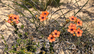
Coppercups
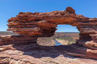
Nature’s Window
We had planned several walks in the park and our initial destination was a rock formation known as Nature’s Window, which stands on top of a gorge wall overlooking a large bend in the partially dry Murchison River 100-metres below. From the car park a set of steps lead down to a tarmac path where you’re likely to be greeted by extremely irritating flies. It’s for good reason many people walking this trail are wearing fly nets, something we should have thought about and will keep with us in future.
Nature’s Window
The trail leads downhill through Mulga shrubs to a small lookout and rest stop with views down into the gorge and along the river. A short stroll further on and the trail becomes a scramble over striped rocky ledges formed from ancient sea floor sediments with ripples still clearly visible in many places. There are a few exposed locations with drops into the gorge that are best avoided, for obvious reasons, and a small stepped rock climb upwards and you find yourself standing right by Nature’s Window.
Weathering of the soft sandstone has created a framed rock hole with views down to the river and along the gorge. Looking quite delicate in places, it has been advised that taking a selfie within the frame is not recommended practice but people still do. And they’re most likely of the thong wearing brigade.
A loop walk continues along the edge of the gorge for 8KM but the flies were too persistent for us to carry on any further.
Kalbarri Skywalk
High up to the left overhanging the gorge are two prominences – both man made. When complete they will form cantilevered lookouts 100-metres above the river. The project, known as the Kalbarri Skywalk, was due for completion in mid-2019 but now in mid-October the $20-million project is clearly way behind and looks unlikely to open before the end of summer 2020.
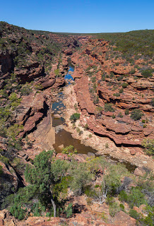
Z-Bend Lookout
Z-Bend Lookout
Our second walk, 11KM to the south, took us to the Z-Bend Lookout. A well maintained gravel track leads through the bush to a view into the gorge along a natural fault line that is responsible for the z-shaped path the Murchison River takes here.
The rock fractures caused by the fault have created an easy straight path for water to flow and erode rather than the smooth rounded bends more normally associated with rivers cut through valleys and gorges. The result is the angled changes of direction of the river and in this case taking the shape of the letter ‘Z’.
For those wanting more of a challenge, and ideally with an accompanying fly net, a nearby track leads down into the gorge and along the 6KM path known as the Four-Ways Trail.
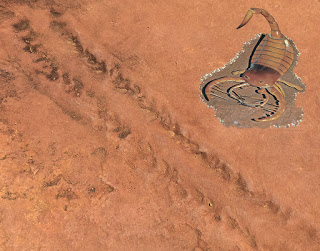
Scorpions
Just before the lookout a display board shows a large, life-sized image of an ancient sea scorpion, a creature you wouldn’t want to step on while walking in the shallows. Beside the sign is a number of fossilised trackways created by this hand-sized crustacean and frozen in time nearly 400-million years ago.
Sea Scorpion tracks
It is believed this creature was one of the very first to transition from the sea to land at a time when plants and grasses were still to appear.
Enough with the FLIES
Having had enough of the flies we decided to head to the coast, still within Kalbarri National Park. Nine sealed roads lead to a number of easily accessible lookouts over the blustery Indian Ocean.
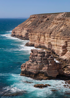
We started with a trip to Island Rock 16KM south of Kalbarri town, which leads to amazing views of the ocean but it is only after leaving the car and taking a short stroll along the sealed path that you get a full view of the magnificent, almost white, sandstone cliffs. These are the most dramatic cliffs we have seen in the six-months of our travels through four-States. Easily the most arresting sight so far and looking very similar to many of the rugged coastlines of the UK.
Island Rock
Island Rock
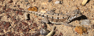
As its name suggests Island Rock was once part of the Tumblagood sandstone cliffs but erosion by wind and waves has undercut the rock finally isolating it to form a sea stack. While walking further along the path towards the next viewpoint I spotted a tiny dragon and managed to snap a few photographs before it dived for cover. It was a new one to us – a Mallee Military Dragon and just 6-centimetres long. Natural Bridge
The strong wind whipping-up the sea and smashing wave after wave against the rocks makes this site all the more impressive. None more so than at Natural Bridge where the waves have eaten away at the cliff leaving a harder section of rock protruding into the sea. Over time, continuing erosion has removed rock along the base until collapsing layers have left a bridge linking the rock to the cliff. Eventually, though, the span of the bridge will collapse leaving a second Island Rock.
Mallee Military Dragon
Snake!!
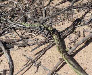
While taking photos of the the scenery I turned and noticed a sizeable and highly patterned snake cross the path into the scrub. Catherine went to take a closer look as I swapped lenses and followed. The snake was partially among the branches of a low-laying acacia but I managed to fire off a shot before it took cover further away. A beautiful looking creature but it wasn’t until the evening before we identified it – a Mulga snake, also known as a King Brown and highly dangerous.
Natural Arch
Unlike the Brown snake the King Brown isn’t aggressive but it will defend itself when cornered. Its venom isn’t as toxic either but it is the quantity, 10-times that of the Brown snake, that does the serious damage. And neither does it give a quick bite and run instead hanging on with a chewing action to ensure the recipient receives the maximum dose.
Despite its name the King Brown is not related to the Brown snake at all, it belongs instead to the Black snake family. It has a venom of unusual qualities that is being extensively researched. Rather than aggressively attack the nervous system or the heart, the King Brown’s venom principally targets striated muscle tissue, those in the legs of most walking creatures and preventing its prey from running away. It also, like many snake venoms, causes blood cells to rupture. A second novelty are two antibacterial agents that are active against the bacteria found in its most common form of prey – amphibians and reptiles. Not only does it keep its incapacitated prey alive it is also able to protect itself from bacterial infection. Now that’s a clever bit of evolution.
Mulga (King Brown) Snake
Recent research into the snake venom’s antibacterial properties has shown one isolated antibacterial agent is seventy times more effective than current drugs and it is hoped this could lead to a solution for the increasingly drug resistant strains of bacteria, the so called Super Bugs.
It’s quite ironic that a creature that strikes abject fear into so many people could one day help save their lives.
Kalbarri, the National Park and the ‘must see’ spectacular coastline have been quite a surprise. Add to that the unexpected wildlife and the wild flowers that we thought we had missed being this late in the season. We still have one more walk to do later in the week and I suspect that will throw yet more surprises. We’ll also be taking our fly nets along!
Fragum erugatum, well known to those with an interest in marine life, is the reason for our visit to a spectacular location this morning. Situated on Shark Bay Road 44KM southeast of Denham is Shell Beach – all 66KM of it.
Cockles
For thousands of years the Fragum cockle has been the exclusive shellfish in this area of the L’haridon Bight. With no predators, hypersaline water and no competing species the Fragum cockle has proliferated and the result is a beach made of tiny shells, trillions of them – in places to a depth of 10-metres. It is one of only two beaches in the world made entirely of shells.
Shell Beach – Shark Bay
Blindingly bright and looking more like snow, it requires a closer look to see that these really are shells.
Growing to a maximum size of 14mm the cockles bury themselves in the seabed with over 4000 sharing the same square metre before ultimately washing up on the shore.
Coquina
Until Shell Beach became World Heritage Listed it was briefly quarried to produce ‘stone’ blocks.
After being washed ashore for more than 4,000-years, the deeper layers of shell become highly compressed. Rain, absorbing carbon dioxide from the atmosphere, creates a weak acid, which leaches through the layers of shells producing calcium carbonate and cementing the compacted shells into a stone known as Coquina.
The stone was hand cut into large blocks and used for building material. A good example of Coquina stone construction is the Old Pearler Restaurant in Denham.
The remains of the quarry still stand and are clearly visible from the beach but are now restricted access though some stones are still being cut but only for repairing existing Coquina stone buildings.
Take a dip
The water in the bay has twice the salinity of normal sea water, which makes it very easy to float in but your skin will get a generous crispy coating of salt in the process.
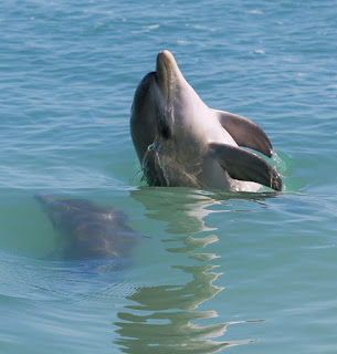
We have been camping in the small coastal town of Denham – the most westerly town in Western Australia with magnificent views across Shark Bay towards Dirk Hartog Island. Listed with World Heritage status, Shark Bay is home to the largest and most diverse sea grass reserves in the world providing food and shelter for Green Turtles, Dugongs, Sharks, Rays and the Indo-Pacific Bottlenose Dolphins that feed on the countless species of fish in the bay’s warm waters.
Monkey Mia Dolphins
Waiting for the Dolphins
The bottlenose dolphins have been visiting the shores of Monkey Mia for at least the past 50-years as first witnessed by local fishermen returning from sea and sharing their catch. It has since become a hugely popular tourist experience with upwards of 100,000 people visiting Monkey Mia each year.
However, over time and through scientific research, it was discovered that over feeding the dolphins led to them ignoring their young calves waiting to feed further out from the shallow water of the beach. Research subsequently indicated a 92% mortality rate for calves born to hand-fed mothers and a far higher rate than other dolphin pods in Shark Bay.
In 1995 new regulations came into force to try and address the issue:
Only mature females with good survival skills are fed
Males are not fed because they tend to be more aggressive
The dolphins are never fed more than a third of their daily food requirements – they still have to hunt for most of their food
Only fresh local fish hunted by dolphins in the wild are given to them. This is to prevent dolphins from developing preferences for ‘foreign’ foods
To encourage the dolphins to spend more time doing their normal activities, feeding only takes place in the morning
There are no set feeding times so the dolphins do not become conditioned and alter their natural wild behaviour
To avoid stress during feeding the dolphins must not be touched and the fish must be readily available when they want to eat.
Since the introduction of the regulations the calve mortality rate has dropped to 23%, which is more inline with other dolphin populations.
Should we, shouldn’t we?
Initially we were in two minds whether to visit Monkey Mia preferring to see wildlife in the wild but having read the guidelines the team of volunteers and researchers at Monkey Mia have the dolphins welfare at heart. The teams also educate the public on the importance of the no-touch, look only nature of the human-dolphin interaction. Hopefully people watching the dolphins will give the same distance and respect to other wildlife they encounter.
Indo-Pacific Bottlenose Dolphin
Fish Anyone?
The dolphin feeding experience starts with the assembled group quietly approaching the water’s edge waiting for the dolphins to arrive – should they choose to. Only once the larger females stay close to the feet of the guides showing they are ready to feed are volunteers brought out with their buckets of fish.
Each guide picks out several visitors that one at a time takes a fish and places it in the water in front of the dolphin. Each dolphin has 100-tiny teeth and placing the fish directly in the water prevents any unintentional bites.
The encounters only last 25-minutes at a time and each one ends as the volunteers wash their buckets in the sea – an indication that feeding, for now, is over. Only if the dolphins return within 25-minutes and wait by the beach does a second or third feed take place and then only between 8am and midday. The dolphins are always the ones in charge. If they don’t want to come up to the beach they are not encouraged to do so.
Where’s the fish?
It is a great experience to get up close to one of the world’s most intelligent creatures and being so close you can clearly see the bites they have received from the sharks they share this beautiful bay with. Just looking into the dolphins’ staring eyes is a very special experience and one we’ll never forget. Absolutely recommended and suitable for all ages.
The dolphin encounter starts at 7.45am and a 30-min drive from Denham allowing for time to check-in at Monkey Mia. Caravan and camping facilities are available at Denham and Monkey Mia.
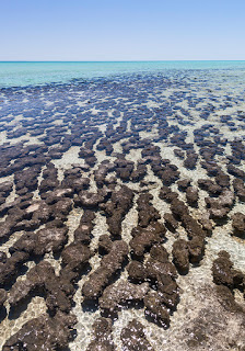
We left Carnarvon this morning heading south on the North West Coastal Highway with a planned stop to see something that happens to be the oldest form of life on this ancient slowly spinning planet of ours and the one responsible for all the early life-sustaining oxygen on our planet.
Stromatolites
27KM from the North West Coastal Highway on Shark Bay Road is the signed turn-off to the Old Telegraph Station and Hamelin Pool Marine Nature Reserve. Just a short stroll from the car park and onto the boardwalk and you’ll be looking at the very rare Stromatolites – living fossils, growing at less than 1mm a year in the shallow, highly saline seawater.
Living Fossils
And you will be standing in one of only two places in the world where living Stromatolites can be found, the other being in the Bahamas. Hamelin Pool is also unique in having the most abundant and diverse examples of Stromatolites in the world.
Cyanobacteria
Stromatolites form in shallow seawater where there is an unusually high concentration of salt. At Hamelin Pool it is twice the salinity of normal seawater. Cyanobacteria, the earliest form of single-cell life on the planet, secretes a sticky gel trapping other Cyanobacteria as well as sand and sediment to form microscopic layers that harden to create the rocky mound-like structures.
The bacteria use water, carbon dioxide and sunlight through photosynthesis to provide energy and, as a byproduct, expel oxygen. It is this oxygen created over 2.5-billion years of the early earth that enabled multi-cellular life to form. Without Stromatolites we and every other advanced form of life simply wouldn’t exist!
Australia – Really, Really Old
The Pilbara region in the northwest of Western Australia is recognised as possessing the oldest known fossils in the world. Prior to Cyanobacteria no fossil records of any life-formns exist. Organic matter from Cyanobacteria in ancient fossilised stromatolites has recently been dated to around 3.5-billion years old.