To survive as a small outback town these days requires the ability to attract passing trade. And it appears to have become customary to try and create, or at the very least promote, something unique about your town to tempt the curious to stop for a while longer than a casual glance or a fuel stop on the way to some distant destination. It may be a collection of old machines stretching for a mile by the roadside as was the case in Ilfracombe, a museum or hall of fame dedicated to some local collection, talent or character such as The Waltzing Matilda Museum in Winton or The Stockman’s Hall of Fame in Longreach, but if it can be made yours only then all the better. And, of course, we must not forget the giant possum, galah, lobster, ram, banana, pineapple…
Nannup
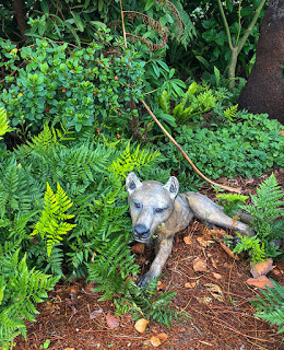
All this brings us to the small and easily passed town of Nannup surrounded by forest at the junction of Highway 10 and Highway 104. Here stalks a local beast rarely sighted but encountered often enough to rouse interest and keep the story alive and in the news. Allegedly a large dog-like animal, of a type previously thought to be extinct, wanders throughout the region occasionally posing for a blurry photograph. The beast has a distinctly long snout with tiger-like stripes to the rear half of it’s body and an unusually long dark tail.
Nannup Tiger
It is thought the creature is a Thylacine – a marsupial carnivore, otherwise known as a Tasmanian Tiger – though the last one believed to exist died in captivity in 1936. Not unique to Tasmania despite its name, the creature became extinct on the mainland about 3,000 years ago but the thylacine is known to have spread as far west as Western Australia and north into Papua New Guinea with fossil records dating back at least 4-million years.
So, it might just be possible in this vast land of ours that a few survivors may still exist out there.
The Nannup Tiger?
But is this just a ruse to attract tourists? After all, Nannup is well provided with cafes and interesting country shops to stop and explore for a while – would it really need to make up such a story? Well, in the brief time that we had to stop for a coffee and stretch our legs along the high street, I was startled to catch sight of the creature lurking among bushes beside the pavement!
It is definitely not a dog. But, despite its rather plastic-looking demeanour and remarkable stillness, it does in fact look like a Tasmanian Tiger and, strangely, it appeared quite happy for me to take a photograph. All I need to do now is add a little blur in Photoshop and add it to Nannup’s collection of sightings.
If you happen to be passing through Nannup, stop for a while, enjoy a great coffee or a meal in one of the many cafes and help support the local economy. And keep your eye out, you never know, you may too encounter the Nannup Tiger.
You may be forgiven, reading this, that we have all of a sudden become troglodytes trying to escape the current cooler weather in the southwest of WA. But, again, we’re heading deep underground to explore one of nature’s relatively young but spectacular caves.
Karri Tree formation
Stalactite overload
We thought Ngilgi Cave was pretty special but Jewel Cave is something altogether different. Situated close to the town of Augusta on Caves Road (where else?), Jewel Cave is the most recently developed of the Cape’s caves open to the public.
Windy Hole
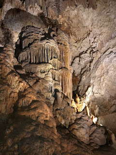
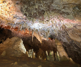
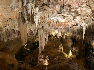
In the early 1900’s a hole in the ground was known about where wind appeared to be emanating from deep below. But it was not formally ‘discovered’ until Cliff Spackman chanced upon a strong upward blast of air from the ground while exploring the area in 1957. The narrow hole had been formed initially by tree roots penetrating the limestone but later widened by the action of water. Cliff’s fellow explorers lowered him by rope through 12-metres of rock to find himself surrounded by a staggering collection of stalactites, stalagmites, pendulums, flowstones and the more unusual, and peculiar, helictites, a crystal formation that Jewel Cave is especially renowned for worldwide.
The following year Cliff, Lloyd Robinson and Lex Bastian returned to further explore the cave, which continued for more than 2KMs and reached down to a depth of 42-metres. And there were more than a few surprises in store. Hidden beneath a layer of soil was uncovered the skeleton of a now extinct Thylacine – a Tasmanian Tiger that must have fallen into the pitch black cave with no means of escape.
The age of the remains are unknown but radio dating of one of the cave’s crystals has put a date on the cave formation at a minimum of 466,000-years and the limestone it sits within a geologically young 1-million years old.
Cliff and his team spent a year developing the show cave as a tourist attraction installing steps, suspended platforms and lighting before opening to the public on Boxing Day 1959.
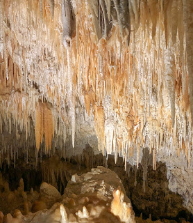
Hundreds and hundreds of Stalactites
Defying Gravity
The cave is absolutely crammed with every type of decoration, as the crystal features are known, but a few take on some quite peculiar shapes twisting randomly, often growing horizontally and even turning right around and growing back upwards as if defying gravity.
Known as Helictites they start as a straw-like formation – a hollow tube. Normally the straw will continue to grow downwards but under certain conditions the dripping water from the cave roof settles more to one side of the straw than the other. With each new layer the direction the straw takes depends on how the calcite’s crystal structure forms.
Giant straws
Among the very special decorations in Jewel Cave is an incredibly delicate straw stalactite just millimetres thick but an enormous 5.43-metres long – the longest found, so far, in any cave in Australia and believed to be at least 10,800-years old.
Delicate Pendulums
Pendulums
A few similar straws have developed bulbous nodules that look like pendulums. It’s hard to imagine how such a delicate straw can support the weight of these growing crystals. Studies have shown that the crystal formations in the cave grow on average 0.5mm each year. Just one slight touch and they could snap and fall destroying tens of thousands of years growth.
Karri Tree Formation In the main cavern is a large flow formation that, when observed more closely, resembles a forest of Karri trees.
Carbon Dioxide
As was the case with Ngilgi Cave the level of carbon dioxide in the air is higher than on the surface above. This is a result of the chemical process that forms the cave’s decorations, a process that has existed for hundreds of thousands of years. Though perfectly safe it does reduce your energy levels while in the cave and requires a little more effort climbing the steps back up to the surface. But it is absolutely worth the effort to be rewarded with such a spectacular example of nature and something a very, very long time in the making.
Today marks the day that we reach the most south-westerly point in Australia, a place called Cape Leeuwin, named by Mathew Flinders in 1801. It is a place where, somewhat controversially, two great oceans – the Indian Ocean and the Southern Ocean – meet.
Oceans Collide – or do they?
It appears all but Australia consider the Southern Ocean to actually begin along the 60th parallel south line of latitude, which is a very long way south of Australia. But let’s not spoil an opportunity to attract tourists to the cape.
Cape Leeuwin Lighthouse
Sitting close to the tip of the cape is Australia’s third largest lighthouse and the largest in Western Australia – Cape Leeuwin Lighthouse. Standing at 39-metres tall, almost twice the height of Cape Naturaliste Lighthouse, Cape Leeuwin’s lighthouse was built from locally quarried limestone and first lit in 1895. Like all other lighthouses around Australia, Cape Leeuwin Lighthouse wasn’t spared the march of ‘progress’ and it too became automated in 1982.
There is a small fee to access the grounds of the lighthouse or a tour of the lighthouse itself giving a grander view from the top deck and a great viewing point for the migrating whales, which pass close by. All proceeds go towards the maintenance and preservation of the lighthouse, cottages and supporting buildings. An onsite cafe serves tea, coffee and light meals with great views of the oceans.
Cape Leeuwin Lighthouse
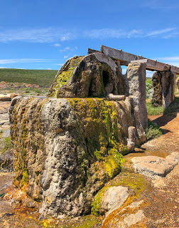
Waterwheel
An unusual attraction in close proximity of the lighthouse is a waterwheel, though it’s not quite what you would expect. Built during the construction of the lighthouse, the waterwheel was powered by a natural freshwater spring and pumped water up to the construction team at the lighthouse for concrete and cement mixes saving transport costs in, what was at the time, a very remote location. Even the limestone was local being extracted from the nearby, and appropriately named, Quarry Bay.
Waterwheel – set in stone
Now, however, the calcium rich water has encased the wheel and much of the pumping mechanism in calcified lime. The water level has since dropped and now an electric pump is used to feed water along the trough to help preserve the timbers from drying and cracking.
It’s certainly an unusual sight but well worth the short stroll from the lighthouse car park even if it’s just to enjoy the views across the bay.
Previously known as Yallingup Cave due to its proximity to the nearby town, it was later changed to Ngilgi Cave, pronounced ‘Neelglee’, to reflect is Aboriginal name. Ngilgi Cave is one of a series of Karst Limestone caves in the southwest of Western Australia. Surprisingly it has had a lot of influence on the development of the region and unusual in that for a visitor it is largely a self guided tour.
Though known for thousands of years by the local Wardandi Aboriginal mob, it was first ‘discovered’ in 1899 by European settler Edward Dawson while searching for lost horses. His chance encounter was a life changing event as he became the resident cave tour guide for the next 37-years.
Stalactites and Stalagmites
Ngilgi Cave is like no other cave we have seen. Stalagmites and stalactites appear as soon as you begin to descend the steep staircase. Here the crystals take on a dull grey colour due to atmospheric exposure and dust but within metres you are standing in a small amphitheater surrounded by every type of crystal structure from straw-like pipes, wavy shawls, cascades as well as the more common stalactites and stalagmites. Every where you look there is something to see.
Karst Limestone
The cave was formed tens of thousands of years ago by a process that continues to this day. Rain passing through the atmosphere absorbs carbon dioxide forming a weak carbonic acid. The acid then intensifies as it passes through carbon dioxide rich soil and begins to dissolve the limestone beneath. Eventually small cracks appear accelerating the erosion and increasing the flow of water through the rock. In the case of Ngilgi Cave the downward passage of water eventually formed a river deep underground that worked its way out to the sea.
39-metres below
Free to wander
Our tour guide, Andre, explained the story of the cave including the discovery of bones from long extinct animals that fell into the shaft of the cave and evidence of Aboriginal habitation dating back 45,000-years. From here you are free to wander deeper into the cave guided by a well constructed path, steps and handrails. Considerable care is needed as the path is often narrow, the cave roof low and the steps steep – and often all three together.
It requires a certain level of fitness made all the more difficult as the humidity and carbon dioxide levels increase the further you descend into the cave.
The path takes you through multiple chambers often with large cracks in the ceiling and huge chunks of rock locked together as they fell but still forming an alarming looking roof directly above. Andre advised us that as well as friction holding the structure in place, secondary cementation by dissolved limestone bonds the rocks together. It certainly looks precarious but it has been this way for thousands of years. Still, you feel as though it could give way at any time or one of the thousands of needle-sharp stalactites may break free and pin you to the ground.
Cascading Stalactites
As you descend deeper the crystals become increasingly white and eventually clear enough for light to pass through. Several have lights behind them showing bands of colour formed by tannins leached from the vegetation above ground.
Taking it all in
The highlight of the cave is a large, circular cavern decorated over its entire surface with thousands of crystal structures. It really is an awesome sight and the place you’ll likely spend most of you time looking and wandering around. Andre had arranged a collection of crystals to look at showing how the colour changes by depth and an opportunity to hold them and realise just how heavy they are. Here is a spot to just admire what nature has created or ask any questions that may come to mind before heading back up the hundreds of steps to the surface. Hidden Treasure
As you begin the accent one last feature will catch your eye. Known as the Jewel Casket, nestled in the cave wall is a miniature grotto with small stalactites that have spiky crystal structures radiating from their tips. These are Dog Tooth Crystals that form where a pool of supersaturated calcium bicarbonate exists. They’re certainly unusual and with the attached stalactites they resemble some form of medieval weapon used to disable your opponent.
The Jewel Casket
The climb back to the cave entrance was much easy than expected, likely a result of the increasingly fresh air, and we were soon back among the scrub where you would have little knowledge that such an amazing sight exists just metres below your feet.
It’s a MUST see
A visit to Ngilgi Cave is very highly recommended but if you are a photographer note that tripods are not allowed in the cave but you are free to use a flashgun. All the photographs here were taken with an iPhone 8 and only the Jewel Casket needed a flash.
Access is suitable for most people including children as long as you are comfortable with confined spaces and a lot of steps.
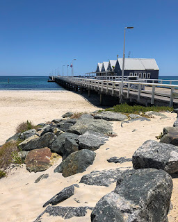
We have seen and walked along some impressive piers and jettys in various countries over the years but perhaps none more so than Busselton Jetty in Western Australia. At 1.84KM it is the longest timber-pile jetty anywhere south of the equator.
Busselton Jetty
The initial jetty, just 176-metres long, was completed in 1865 and provided a much needed facility for ships to dock at a time when agriculture, tourism and the timber industry was booming. At that time there were no personal income taxes instead the government sourced revenue on imports and exports with the jetty no doubt soon paying for itself.
In 1872 at a cost of £88 the jetty had its first extension to enable larger ships that were finding Geographe Bay to shallow to dock. However, just three years later the extension proved insufficient and with silt building up in the bay another 144-metres were added, this time costing a more considerable £626. Silt continued to build and in 1884 another 229-metres were added. Then another 353-metres three years later and another forty in 1890. And we’re not done yet…
More, bigger
The increasing size of ships required deeper access and so more extensions were added: 130-metres in 1894, 150-metres in the following year and 261.6-metres the year after that. By 1907 the jetty had reached just short of 1.4KM. But, as you will have gathered by now, there was a trend developing and they still had not yet finished.
One BIG Jetty
A rail line was added easing the transport of goods and replacing the existing horse and cart but it also introduced a new problem – fire. Embers from the steam powered engine often took hold on the timber deck requiring someone to follow behind the train stamping them out.
Then in 1911 an additional 603-metres was added. This, and two-months of dredging, allowed even larger ships to dock safely bringing in tourists to visit Western Australia’s first major tourist attraction – Ngilgi Caves, more of which to follow. Sea baths were also created to allow visitors to swim safely away from the ‘Sea Monsters’ and a pavilion for band concerts. Busselton was booming.
One LONG walk
Finally one last addition of 16-metres in 1960 brought the jetty up to its current dimensions and the longest of its type in the Southern Hemisphere. But it was all too late to continue efficient operations as the larger port at Bunbury began to take business from the jetty and in 1972 it was closed to trade as a shipping port. Five thousand ships had used the jetty over its 100-years service and significantly helped the development of the South Western corner of Western Australia.
End of the line
Although the jetty’s port operation days were over it wasn’t the end of its working life. Though the state government had it in mind to be dismantled, the local community and Shire campaigned to take control of the jetty and develop it as a tourist attraction even proposing adding an underwater observatory. Nature, though, had other plans and on April the 4th 1978 cyclone Alby swept away 700-metres of the oldest section of the jetty. And there the jetty remained, isolated from the shore and gradually succumbing to the effects of the weather and sea.
However, this was a jetty that had no intention of coming to an end and a survey of the community by the Shire received a 90% response in favour of preserving the jetty and resulting in a $500,000 kickstart fund being allocated as well as the formation of the Busselton Jetty Preservation Committee. Funds raised and the injection of the promised money from the Shire allowed the first part of the major restoration to start at a cost of $660,000.
Old Jetty timbers
In 1995 a small train was re-introduced using the original rails and charging a fee to take people to the end of the jetty and back. It additionally allowed the mobility impaired to enjoy the views and fresh air along with the fishing, swimming and sporting events already popular. Diving also became popular and the jetty has become one of Australia’s top ten dive sites.
Fire!!
In 1999 a huge fire took hold and destroyed a 70-metre section of the jetty. Only cutting through sections of the timber deck with chainsaws halted the flames. The fire was believed to have been started by a carelessly discarded cigarette. In order to help raise funds sufficient for significant incidents like this an underwater observatory was created and put in place at the end of the jetty. In the first 6-months from December 2003, 60,000 people took the opportunity to view some of the 300 marine species that call Geographe Bay home.
In 2009, the Western Australia State Government donated $24-million for the complete restoration of the jetty to return it to an ‘as new’ condition, which included replacing the remaining fire prone timber deck with cast concrete panels. And on the 6th of February 2011 with thousands of people attending, Busselton Jetty was re-opened.
Jetty Shop and Museum
But wait, there’s more
Not content, plans are now underway to add a giant glasshouse on the last section of the jetty with a cafe and sunset bar. It will be lit at night providing a warm glow and highlighting the enormous length of this much loved piece of historic architecture.
And finally…
Interestingly, and perhaps to encourage youngsters to make the full walk to the end of the jetty, a number of plaques along the way pose a series of questions about the jetty with each subsequent plaque holding the answer and presenting the next question. We have seen similar with roadside signs on some remote highways to help alleviate the boredom of long journeys. Quite educational too.
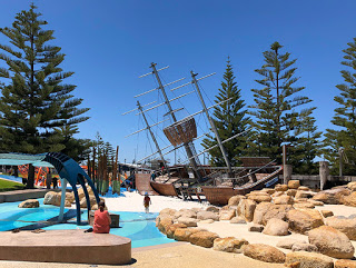
Foreshore Playground
We thoroughly enjoyed our walk along the jetty and wandering around the excellent work that has taken place on the foreshore with new parking facilities, landscaping, eateries and the best children’s adventure playground we’ve seen anywhere with a huge listing ship, a giant squid and a whale swimming through the wake of the ship.
Busselton in a fast growing town and absolutely worth a visit on your West Coast trip. So much so we extended our stay.