El Questro

We bought our Land Rover Discovery 5 for its ability to go off-road and to tow our Jayco Silverline Outback caravan. Today was the first time we put the combination to test on the gravel access road that leads from the notorious Gibb River Road to El Questro where we’re staying for the next three nights.

Now for those not familiar with the Kimberley and northern WA in general, this region of the country is often referred to as Australia’s last great wilderness and it has the remoteness and dirt roads to prove it. Our drive into El Questro was supposed to be on a relatively good road but here ‘good’ should be used only as a comparison to very bad roads. Severely rutted enough to shake fillings loose and scramble eggs, the road contained just as many loose rocks as a landslide.

Where’s the Grader?

According to a sign at the start of the 14KM track the road was in the process of being graded to flatten out the ruts. I can only assume the grader was taking a holiday elsewhere. But this car and caravan were designed to handle this kind of torture even if we, with our ageing backs, were not. Then added in to the mix were the inconsiderate drivers going in the opposite direction as fast as they could creating clouds of dust that forced us to slow even further until we were able to see again. The challenge of cornering on a loose surface with a large vehicle in tow was soon mastered and then came the first of two water crossings.

Water Crossings

Some person we had met earlier had advised us that the crossings were dry. Clearly they had been nowhere near here. It hadn’t rained for months but there was certainly a lot of water and loose, hidden boulders in the first crossing. Still, no problem, we have a high clearance caravan with independent suspension and a 4WD car that can handle a wading depth of 900mm. So, into 4-wheel drive, high clearance and auto traction control and off we went with ease until halfway across… and we stopped. For some reason the auto mode decided we were going downhill and switched to hill decent control. Never a good think to stop in water, I quickly switched to manual control, rock and gravel mode and off we went  again for the remainder of the crossing and up the ramp back onto dry land.

More rough road, more inconsiderate drivers and then the final water crossing. This one three times longer and looking twice as deep. In we went, still in the same 4WD mode and an oncoming driver decided he was going first. Eventually he realised he was in the wrong and backed-up, something we could not have done and the crossing was wide enough only for one vehicle. With a small wave in front and to the side of us and the sound of rushing water coming up the doors, we sailed through without issue and up the bank onto the final stretch of road into El Questro and the Black Cockatoo Camp Ground.

The car and caravan had proven their worth easily handling the challenging conditions even if they were both now coated in a layer of grey dust and about to get a covering of red dust at the camp.

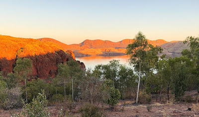
El Questro is an enormous property covering 1-million acres and home to many outstanding natural features, gorges, rivers, fauna and flora – the very reason for our visit and the effort it took to get here.

El Questro Sunset

Tonight is pizza night at the outdoor camp restaurant and after a beer or two, the rest of the day is set aside to relax and rest our aching joints ready for the adventures that lay ahead.

Lake Argyle

Three times the size of the UK and with a population less than 40,000, the Kimberley in Western Australia is one of the oldest regions on earth.

Sunset from Lake Argyle Resort

We’re staying at the edge of Lake Argyle, an enormous man-made reservoir, in the northeast of the Kimberley.

The Lake Argyle Resort sits just above the lake giving views across the water to many of the lake’s islands, bluffs and sandstone hills, which light up at sunset and sunrise. Just how many campsites can provide a view like this in such an unspoilt and remote location?

There are plenty of things to do here for the adventurous and those who prefer to relax by the infinity pool soaking up the sun. Walking trails, 4WD-adventures, helicopter flights, boating, fishing…

Bush Walks

What better way to start exploring our new location than a bush walk to a viewpoint high above Lake Argyle.

Our walk starts directly opposite the campsite and follows a steep, winding path up the escarpment. Tall, dry grasses line the rocky path with sparse trees and shrubs baking in the heat from the sun. It all feels as if one small spark could set the entire escarpment off in a raging blaze.

Lake Argyle and the Ord River

The effort of the climb is rewarded, though, with magnificent views of the lake and its islands as well as the view back along the Ord River as it flows towards the town of Kununurra. Clumps of bright green grasses dot the hillsides providing contrast to the ancient orange sandstone. And at the head of the river is the Lake Argyle Dam wall. Not huge in the grand scheme of things but impressive in the volume of water the wall is holding back.

To gain a better view of the dam I dropped down from our viewpoint and followed the road down to a lookout just above the dam’s wall and hydro station. From here you get a better view of just how steep the dam walls are and it’s method of construction comprised almost entirely of loose rock and boulders with a compressed core of clay. It’s loose construction was designed to be flexible enough to cope with earthquakes, common in this region of Australia, something that a concrete dam is more prone too. It is especially important in this case as it sits right on top of a fault line and an earthquake in 2016 proved its worth with no damage recorded.

Since construction was completed in 1971 the 98-metre high wall has dropped just 4.5-centimetres due entirely to natural settlement.

Just two-years following completion, heavy rains in the wet season filled the dam to flood level with water pouring from the emergency spillways. They continued to flow through to 1984. In 1996, following concerns of sediment reducing the dam capacity, the spillways were raised by 6-metres doubling the capacity of the lake and plans are in place to increase the level yet further.

Sunset Cruise

Our main trip today, though, was a sunset cruise on the lake, something we had both been looking forward to. Starting from the campsite car park, a coach takes you down and across the dam with a guide explaining the history of the construction project and the attempts at farming in the area. Surprisingly the hydro station was not added until the early 1990’s, 20-years after the dam was completed though provision had been made for it during the original construction.

Freshwater Crocodile

Our cruise aboard the Kimberley Durack took us from Bamboo Creek southwards to an area popular with swimmers. Immediately behind their moored boats was some of Australia’s oldest know rock approximately 1.5-billion years old. That is long before any known life form existed on the planet. The cruise then continued around the headland towards crocodile bay, named after, not surprisingly, one of its many inhabitants.

Crocodiles

The lake is home to somewhere in excess of 35,000 freshwater crocodiles. It seems an excessive number, calculated at night using torches to pick out the reflection of their eyes, but this is a lake of excessive proportions. Measuring 703-square kilometres (271-square miles) and a catchment area forty-six times larger, the lake holds 10,763-billion litres of fresh water. That is the equivalent of 2.5 cubic miles with an outflow capable of supplying the entire country’s annual water needs every 3.5-hours.

Wallaroo and Joey

And not surprisingly, sat sunning themselves in the bay, were several freshwater crocodiles. They are timid creatures with a narrow snout designed to catch fish and pose little threat to people. Our cruise guide, Grant, pointed out that they don’t believe any estuarine (saltwater) crocodiles exist in the lake based mainly on the distance of the inflowing rivers from the sea to the north. But with that volume of water who knows?

The cruise then took us past a distant view of the opencast Argyle diamond mine and towards the lake’s largest island where several unique and well camouflaged wallaroos gathered on the shoreline to feed. One female was carrying a young Joey in her pouch but was quite happy with our presence as we all gathered to take photographs.

Yes, this really is a lake

Further into the lake and the scale really started to show. Right in the very distance were rocks at the eastern edge of the lake – over 20KM away, and that was just one small section of the most northerly region of the lake.

With the sun getting lower in the sky, the cruise moved on to a clear area of the lake where everyone was free to jump in and swim or just float around with a pair of noodles and a glass of wine or stubby of beer in their hands. Below them was 23-metres of clear, mostly crocodile free, water.

Catherine enjoyed a dip where the water was a little warmer than expected but still ‘cool’. As for me, I kept a lookout and helped supply those less wary with drinks and nibbles.

Setting Sun

Finally we started to head back as the sun faded behind the hills and put on a light show worthy of any we’ve seen to date. All we needed were a few more clouds to add colour to the sky, but those, as we’ve found over the last two months, are quite a rarity during the dry season.

Lake Argyle Sunset

It was another great trip and highly recommended. Just remember to bring along your swimmers, thongs, suncream and a can of crocodile repellent spray.

More details at: www.lakeargyle.com-cruises-tours-activities