After a bad night for me with my arthritic back flaring-up, I sadly had to call-off today’s walk but Catherine and our travel buddies, Lloyd and Jill continued 58KM on tarmac and then another 50KM on a relatively smooth, comparatively speaking, unsealed road to Hamersley Gorge with just a 2KM drive into the National Park, the first half being very rough.
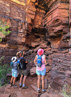
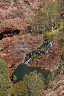
Hamersley Gorge – folded strata
The geology of Hamersley Gorge is quite different to the other gorges we’ve explored in Karijini. Hamersley Gorge is comprised of very different rock formations with much thinner layers and far more contorted. Very unlike the ‘Jenga’ block formations at Dales Gorge.
After a short climb up to the gorge lookout, we made our way down the Grade 4 steep and uneven steps down into the gorge. Summoning up our courage, when then decided to tackle the Grade 5 hike to Spa Pool. Immediately we came across a 30-degree incline on a large slab of rock, thankfully, though, there were some upright rocks close by to use as hand holds. We all managed our way up and over the next few rocks to a steel ladder, which leads to the main pool.
Hamersley Gorge Pool
Access to Spa Pool is easiest as a swim through the main pool during the dry season. After taking a few photos we took the plunge, rather inelegantly, into Spa Pool for a quick, and somewhat cold dip. And the easiest way out being just as inelegant with a short swim back to collect our gear perched on the rocks.
After a quick dry-off in the warm sun, we made our way back down into the gorge. While the ladder was the easy part, we were challenged again by the 30-degree slab of rock wearing wet shoes. A shimmy down on our buts cleared the obstacle without injury, though bruises may follow, and we all high five’d our completion of this confronting, though rewarding Grade 5 walk. Our reward was a climb back to ground level in time for a well earned lunch and some much needed relaxation.
The reward – Hamersley Spa Pool
Rested and armed with pool noodles we climbed our way back down the steps for a float along the river that follows the line of the gorge. Little of the river receives sunlight so the water was somewhat refreshing but it was a unique, enjoyable and worthwhile experience before returning to the car park and making our way back to our camp at Dales Gorge – Happy Hour is calling.
The last walk of our Dales Gorge visit was an extension of our first walk to Fortescue Falls but this time negotiating the 286-steps was a one way trip. But it did mean we had to traverse the falls, which meant clambering down the rock face on the dry side. Dry being a temporary feature towards the end of the dry season, during the Wet the falls are a raging torrent entirely submerging the rock we climbed on.
Much less of a challenge was crossing the pool where the water from the falls narrows and heads downstream. Loose and slippery stepping stones adds some entertainment and tests the balance but the worst that could happen is you slip into shallow water losing your pride and gaining a few bruises in the process.
The walk continues through a mix of paperbark and spotted river gums, grasses and impressive views of the surrounding slabs of rock stacked precariously above. It looks as if a sneeze could cause some of these to topple but one spot in particular demonstrates just how secure some of these rock walls are – at least for the moment.
Delicate Window Frame
One very, very slender column of rock is holding up an enormous weight of sandstone above it though for how much longer is anyone’s guess. Just one tap from a hammer would see this structure collapse bringing down thousands of tonnes of iron-rich rock. Though being warned to the contrary, many choose to stand where the column frames the gap against the rock wall for a selfie. Again, natural selection will one day take its course on the stupid.
The walk includes many pools and small waterfalls along the way some providing further challenges and sometimes requiring stepping stones or a scramble along the rock wall. It’s a very peaceful and relaxing place and a great pleasure to be surrounded by so much greenery. Each of the gorges creates its own microcosm with often rare or unique plants and the benefit of water clearly shows. it is such a contrast to the red, dry and dusty desert with have been travelling through for many weeks now.
Circular Pool Walk Falls
Now, far below the Circular Pool Lookout, the path becomes a little more of a scramble over rocks, rock slabs and boulders. As such this section of the walk is designated a Grade 4 out of 5. Despite the warnings to wear appropriate footwear the thong wearers still aren’t deterred. Not only do they put themselves at risk but also those that have to rescue them – many of them volunteers.
Mind where you step
Just yesterday on this very walk a person was bitten by a snake, believed to be non-venomous, and had to be extracted by a team of rescuers and medics up a very steep pathway to a waiting ambulance. Death Adders and King Brown snakes both populate these gorges and surrounds and thongs offer absolutely no resistance to needle-sharp fangs.
We paused for a while looking at the delicately balanced rocks above and around us. Obviously these rocks eventually part and crash to the ground but it is amazing how they appear to hang on that little bit longer in the most unlikely positions. The park rangers have seen where new rock falls have taken place but none have ever witnessed them tumble. As you walk below many of the overhangs you have to wonder just how soon someone is going to get a piece of landscape heading in their direction.
Anyone for a game of Jenga?
Finally, and quite suddenly, we reached our destination of Circular Pool to be greeted by a small group of people, some who had braved the cold water already and a few about to take a dip. Circular Pool, like Handrail Pool, was created by the action of water during the wet season and abrasion from swirling rocks and boulders to produce a near perfect circular hole in the ground over 100-metres deep.
Even now during the dry season water flows into and out of the pool supporting shrubs, grasses, spotted gums, paperbark trees, maiden hair ferns and a wide variety of wildlife. It’s an impressive sight but one difficult to photograph due to the extreme contrast of light and the angle of the sun at our visit.
A rest was in order – a coffee would have been nice, or even an ice-cream – and the many boulders that had fallen over the years made convenient seats for the weary. But a little of the fauna had got there before us. Ants of every size and type, we discovered some time ago, are everywhere in the deserts and this spot was no different. They, like flies and mosquitoes, also have a predilection for anything black and in particular my camera bag it seems. I didn’t sit around for too long!
Circular Pool
Turning around, we slid, scrambled and clambered our way back over the rock slabs to the very steep, stepped track back up to ground level, stopping many times to admire the view – or catch our breath depending on how honest we were.
A great walk and just a short stroll from our campground. Absolutely recommended. It’s easier than it may sound but good walking shoes, a walking pole, plenty of water and a good sense of balance is all that’s required. Just prepare to get hot. Even in the cooler dry season temperatures in the mid-thirties are the norm and temperatures begin to rise again in late September.
Today is another adventure on our exploration of the hidden gorges of Karijini National Park. It’s also the big one on our list and a challenging one in several ways. We’re heading to Weano Gorge and the Handrail Pool.
G’Day Bruce
Leaving Dales Gorge and we have 80KM of blacktop to our next turn-off and very little change of scenery along the route with the exception of a few rather large hills. They are in fact mountains and one of them: Mount Bruce is actually Western Australia’s second highest mountain.
While on the subject of mountains it wouldn’t, of course, be Australian without a Mount Sheila and, yes, one happens to be close by – I kid you not. Whoever named the remaining peaks in this region, though, must have run short on names, was tired or just couldn’t be bothered with the next one being thoughtfully named: Mount Nameless. We briefly pondered a detour for a climb up Mount Bruce until its apparent increasing grade persuaded us otherwise.
Just under an our from set-off we neared our turn – more clearly identified by the red stained tarmac than the road signs on approach. We’re now greeted with some of the roughest, rutted dirt road we have had the uncomfortable displeasure of experiencing. And part of the reason is the idiots driving well beyond the speed limit churning up the road and sending clouds of dust into the air. Likewise the same mindless people overtaking us with oncoming traffic so neither can see through the cloud of dust and gravel kicked-up in the air. Perhaps not coincidently they are usually company utes or hire cars. This was, however, a good opportunity to test out the Terrain Response modes of our Land Rover Discovery 5.
Comfort mode would provide some restpite from the punishing ruts of a normal dirt road perhaps but not this one. Sand, gravel and snow would appear to be the best to cope with the loose ground but still the ruts were winning. Mud Ruts didn’t give us the power we needed to get on top of the ruts and minimise the vibration so we opted for Comfort, which seemed the best compromise. Still, 13.5KM was far from enjoyable. Maybe if we had been in a hire car it would have seemed much smoother… and quicker.
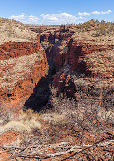
Joffre Falls
Our first destination was a brief detour from the main track, which led us, though badly signed, to Joffre Falls Lookout. Now if Circular Pool was a jaw-dropping experience, then I need to revert to a thesaurus to find some other words appropriate to describe the view as you begin to look further and further into this gaping chasm in the ground. It is way deeper than you would expect and far, far more dramatic. This was akin to looking down into the Grand Canyon for the very first time only darker and more foreboding.
Joffre Falls – Mount Bruce in the background
Deep down, a narrow channel of water flows from the falls, which by now, towards the end of the dry season, is little more than a trickle and a partly dry circular basin. Voices could be clearly heard from below and with a little searching we spotted several people clambering over rocks along the bottom of the gorge.
Then more voices as we watched nervously as a small group struggled their way up the opposite rock wall. It is probably every bit as steep as it looked from our vantage point. Then, to our utter disbelief, two young girls started the climb down into the gorge in bare feet!! You really have to wonder what has become of common sense nowadays. Sadly, as we have seen several times now, many adults are just as oblivious to the serious nature of these walks and the personal responsibility that goes with them. Perhaps evolution has taken a wrong step somewhere along the way.
Joffre Falls – click to enlarge
For a reference of scale the photograph to the left was taken with a telephoto lens showing just the lower third of the gorge. There are three people in the image and they have to climb that rock face to exit the gorge.
One last drive, a brief teasing patch of tarmac followed by more ruts and we arrived at our goal – Weano Recreation Area and an experience we’ll never forget.
Oxer Lookout
To get a taster for what we were about to see we took the short stroll over to Oxer Lookout, which gives dramatic views where Weano, Hancock and Red Gorge meet. The red rock is even more spectacular in the early morning and late afternoon as the sun sinks to the horizon.
Oxer Lookout
Weano Gorge
Now those who have studied the park guide in advance may notice something rather odd about the map displayed at the start of the gorge walks. After a little reflection you may notice that the map is upside down, but rather dangerously, the north pointer is still pointing upwards. Follow this one using a compass and at best you’ll find yourself on the wrong walk and at worst lost. Getting lost here with no mobile phone coverage and the real risk of venomous snake bites is something you really do not want to experience. As soon as we are able we’ll be notifying WA’s National Parks Service.
Weano Gorge walk offers a brief glimpse of what to expect as you follow the gorge rim, but how wrong could you be. Something far more dramatic, far more spectacular awaits those that can cope with a grade 4 and 5 walk and at the same time don’t mind getting a little, or a lot, wet in the process.
A relatively easy walk down to the gorge floor finds you among deep orange and rust coloured vertical rock walls to a mostly level walk. Spotted River gums line the path with tall, healthy looking grasses. Several shallow pools of water remain reflecting the colour of the rocks and the white tree trunks of the gums.
Weano Gorge
In places the path requires an easy scramble over rocks and well placed stones help cross the few wet patches. After a few more scrambles we reached our initial destination hemmed in by the gorge walls. A path then leads diagonally uphill to the top and the end of the walk.
We had initially chosen to walk to the curiously named Handrail Pool another day but having spoken with another group at the end of our current walk we decided to continue further and we were so glad we did.
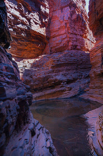
Handrail Pool
Continuing on the gorge gradually narrows and twists and turns past a few small pools easily crossed by stepping stones until reaching a larger pool, which requires wading through shin-high water or for those with a good sense of balance a delicate clamber along the exposed rock wall. We chose the water route but crossed bare foot – Gortex walking shoes are just as good at holding water in as keeping it out. Besides, the pool’s cool water provided a very welcome relief in this hot weather.
Weano Gorge – narrows
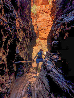
Becoming increasingly narrow the path is more challenging with large rectangular rocks and boulders to negotiate until closing in further with a trickle of water on the slippery layered rock under our feet. And then, wow. The gorge opens into a small circular chamber glowing orange in the shaft of sunlight and reflecting off a clear pool of water. The colour of the rocks are stunning with every shade of orange through to purple and even blue where the polished stone reflects the blue sky above.
The chamber had been formed by the rushing water that courses through here during the wet season with the aid of rocks, stones and boulders that swirl around scouring the gorge walls.
From here the gorge walls narrow even further allowing for the more athletic to spider walk above the water during the wet season. Right now hardly more than a trickle runs through but even with walking boots the smooth rock offers little grip and a slip could easily result in injury or a twisted joint and it is far from an easy exercise to extract an injured party from such a narrow passage. It should be remembered the nearest source of emergency services are in the town of Tom Price 90KM away. Walkers within the National Park are advised it could potentially take up to eight hours to be rescued.
Weano Gorge pool
The passage eventually leads through to the impressive and much larger Handrail Pool. It’s more of a challenge than we had expected with the weight of our camera bags, slippery rock and a downward facing slope. We held on tight to the oversized steel handrail from which this pool gained its named.
It is possible to get a good view of the pool and its vertical rock walls without climbing down any further but it is quite a precarious position and needs careful balance and a little courage to let go of the handrail to take a photograph. The wearing of brave pants is advisable.
The handrail, fastened to the left hand rock wall, slopes down towards the biggest challenge of the walk where it drops vertically down to a narrow gravel base that edges the pool. The decent requires straddling the handrail and feeling for the foot supports widely spaced below.
Surrounded by rock walls the pool water receives very little direct sunlight and as a result it’s cold, very cold in fact. Warnings are posted at the start of the walk advising of the risk of hyperthermia. Still, a few people couldn’t resist the challenge. We were happy just to take a few photographs before carefully turning around and retracing our steps.
Access to Handrail Pool
Returning to where we had waded through the pool blocking our passage earlier a dry route along the rock wall looked more passable than we had initially thought and a bit of scrambling had us clear and dry and soon making our way back to the steep accent leading to the top of the gorge.
We had planned one final walk but a view from the Hancock Gorge Lookout soon had us changing our minds, perhaps a bit more of a challenge than we were ready for and we still had a tough drive ahead of us to get back to our campsite.
Australian photographer, Ken Duncan, has created many stunning photographs of the gorges within Karijini National Park and Weano Gorge among them. It was through his images that we first learnt of Karijini National Park and we’re so glad we have been able to visit. Thanks Ken.
We’ve finally made it to another of our Bucket List destinations. Over the next five-days we’ll be exploring Karijini National Park and its spectacular gorges.
The drive from Port Hedland towards Karijini on the Great Northern Highway is one of the busiest Road Train routes in Australia. Mostly carrying iron ore from mines to the south, economics mean a more direct train line is not practical. The trucks are running 24×7 and travelling faster than the 100KMH limit for towed vehicles in Western Australia. That requires caravans to give way to rear approaching traffic and keeping as far to the left as possible as Road Trains approach from ahead. A quick call out on UHF 40, pulling over as far as possible and slowing a little is always appreciated.
Arriving at Karijini National Park is initially a little let-down. The drive into Dales Gorge, our camp location, provides no hint as to what awaits. Virtually flat with mixed scrub, spinifex grass, lots of dust and distant hills give nothing away despite the fact that our campsite is just a few hundred metres from one of the best and easiest to access gorges.
The Sky at Night
An unexpected treasure currently in Dales Gorge is an astronomy viewing experience by the highly knowledgeable and equally entertaining Phill Witt of Remtrek Astronomy. This 2.5-hour guide to the night sky is a must on a visit to Karijini with warm evenings and an absence of light pollution that otherwise spoils the view of the heavens – even with the high and bright moon on our visit, which, as it happened, had its benefits.
Phill will have you laughing right from the start with his quick wit and visitor involvement while describing the night sky and its many wonders. You’ll soon be able to identify the Southern Celestial, which will guide you towards the south, our closest stars outside of our solar system – Alpha Centauri and Alpha Proxima as well as many of the signs of the Zodiac – some clearly more obscure than others.
Then the real fun begins as Phill trains three telescopes, cutely named Baby Rex, Middle Rex and Big Rex, onto Alpha Centauri. With the naked eye we see only one star but through the telescopes Alpha Centauri is clearly not one but two stars – Alpha Proxima being the other.
Next is just a faint blur to the eye, known as the Omega Centauri globular cluster, but the telescopes reveal a minute patch of sky comprised of approximately 10-million brilliant stars 16,000 light years away. A little closer to home is the coloured Jewel Box at a mere 6,440 light years.
The Moon… Obviously!
A mind blowing view of Jupiter with its Great Red Spot and moons followed by the spectacular angled view of Saturn and its rings only 10-metres deep. For such relatively affordable telescopes the detail and quality is amazing. Finally a close-up view of the moon, where Phill will capture the image on you own mobile phone, Samsung so obviously preferred by Phill, but just as good on an iPhone.
A very educational and entertaining evening and what better than a chocolate Milky Way bar to take away as a reminder of that enormous glowing vision we get to see in these special Dark Sky locations in Australia.
Circular Pool from lookout
Dales Gorge campground is conveniently positioned close to several of Karijini’s highlights and our first exploratory walk was just several hundred metres to Circular Pool Lookout. Best explained as a jaw-dropping moment and a place you will here the word ‘wow’ spoken in many languages. The high contrast light makes photography difficult here – you’ll have to take our word for it.
Circular Pool is an enormous circular hole carved out of the ground by water over countless years at the head of a long gorge with vertical rock faces comprised of iron bearing sandstone, dolomite, shale and traces of blue asbestos. A trail that drops steeply into the gorge is one we shall be exploring later in the week.
Exposed asbestos seams
A brief trial mine of asbestos proved uneconomical due to the narrow bands where it is exposed. It is, however, a risk to those exploring the gorges and the National Parks Service have placed warning signs advising of the danger and to leave well alone.
We followed the gorge rim passing Ghost and Spotted gum trees and mounds of needle sharp Spinifex grass. Sitting or falling on one of these is bound to be a highly uncomfortable and memorable experience. Still, they look amazing with their light yellow colour contrasting with the deep orange soil we’re surrounded by. From the rim you get an idea just how old some of these rocks are by the number of alternating coloured layers that reach over 100-metres to the base of the gorge. It is believed the oldest rocks date back 1.5-billion years – long before complex life forms existed on our planet.
Fortescue Falls
Our rim walk led us to the Fortiscue Falls Lookout, which during the wet season is a raging torrent of water, but today, towards the end of the dry season, is a pleasant tumble of white silky veils. Fortiscue Falls is unusual in that the fall is comprised of regular rectangular blocks of sandstone layered like a staircase. It makes reaching the pool at the base that much easier to access but unfortunately that means, yet again, this is a place for people to swim, to cool-off after a long hot walk and pollute the water with suncream.
As I’ve mentioned before, to me swimming in a National Park is just wrong but it is the Australian way. Any hope of getting a half-decent photograph of this natural wonder is going to require some judicial editing to remove people from the shot.
To reach the falls requires little effort as long as you are comfortable climbing 286-steps down the cliff-face. That of course means a return trip of the same number of steps to warm you up again after that cooling dip. There are, however, two paths that lead further from here, one crosses the falls and follows the gorge downstream and the other, which we will follow leads to Fern Pool.
Fern Pool
Having been surrounded by high cliff walls it comes as a surprise when you walk just metres from the falls into a peaceful wooded glade full of bird song and the screech of fruit bats. All of a sudden everything is bright green with tall grasses, paperbark trees and maiden hair ferns clinging to the damp stone below giant fig trees.
The short walk leads to an opening in the trees where a small waterfall tumbles into a large, clear pool of cool water. It is such a stark contrast to Fortiscue Falls and the surrounding gorge. It’s also equally as attractive to swimmers. The wet season will, however, provide a very different view of this peaceful setting – just a wild, turbulent body of water feeding Fortescue Falls.
The second path leading from Fortiscue falls is one we will follow later in the week. For now, though, we’ll just be glad to reach the summit of all those steps, cool-off and chill-out for the rest of the afternoon prior to Happy Hour.
A very early start today to meet with our tour at 6.15am but at least we get to see a WA sunrise as compensation. We had been warned that we were in for a rough ride along the rutted gravel road to our destination and it was, very rough. But getting to see special places like today’s in Australia is rarely easy, or comfortable, but worth it.
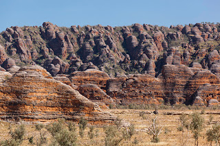
Purnululu – North
Today we are heading out to Purnululu National Park, a World Heritage Site, previously, and more popularly, known as the Bungle Bungles. Little known or explored by Europeans until an ABC TV programme filmed in the area in 1983, when public and scientific curiosity was aroused. What had created these spectacular black and orange stripped, beehive-shaped rock domes?
The Bungle Bungle Range has been on our must visit list for many years and today, finally, we were not only going to see them but also walk among them. And more…
Rough Ride
Our 4WD bus didn’t look in the best shape, but then what would after 450,000KM on dirt roads. It still had life in it and apparently coping better with the Bungles than the new bus that was shedding nuts, bolts and passenger seats. But an hour of bone-jarring ruts, bumps and floodways, past ghost gums, mounds of spinifex, dry creeks, feeding wallabies and moonscapes, got us to the Purnululu Visitor Centre. We still had 30-minutes of rough road ahead of us to reach our destination but everyone was ready for a break and a chance to stretch and put joints and false teeth back in place.
The Domes
There are some enormous escarpments along the route, moonscape-like hills and green valleys full of ghost gums, not what we had expected to see from all the published photographs, but these were just a teaser to what we finally started sighting – the characteristic stripped domes of the Bungle Bungles. And it wasn’t long before we were enjoying our morning tea break stood right in front of these amazing, other worldly domes.
Purnululu National Park – The Bungle Bungles
What, on first appearance looks to be different layers of rock, the domes are actually comprised entirely of almost white sandstone. The orange bands are layers where water from the wet season has seeped to the surface taking iron along with it and rusting where it is exposed to oxygen. This is the same process that causes the classic red earth and rock of much of the north and west of Australia. The black bands are also the result of water seepage but have a higher moisture content allowing Cyanobacteria to grow on the surface. These are the same single cell life forms that were known to exist 3.5-billion years ago, one of the earliest known forms of life on this planet.
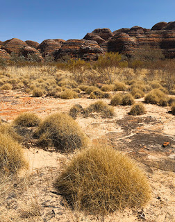
Spinifex and Beehive Domes
You have to ask where this sandstone came from in the first place, after all sandstone was once just loose sand formed by the sea, glaciers or rivers. A clue is visible in narrow bands of the rock walls. In this case pebbles of an ancient river are embedded in the sandstone showing this area has had fast flowing water for millions of years. But in turn those pebbles were at one time themselves, chunks of rock that tumbled from ancient cliffs into flowing water. Research suggests the rock that forms the Bungles is between 350 and 400-million years old and their current form has been created over the past 20-million years.
Our first walk took us around many of the sandstone domes along a dry creek for a close-up view where our guide, Steve, explained the process that created them and the related human history. They look delicate, and in places they are but the Cyanobacteria is helping bond the sandstone surface slowing its erosion. Needless to say we were all looking through our viewfinders for the best place to take a photograph as we continued our walk.
Domes Walk – Riverbed
The Aborigines have known of these features for tens of thousands of years and many areas are held sacred by them but the first Europeans that passed through on cattle droves thought them nothing remarkable. By contrast, in 2003, Purnululu was added to the UNESCO World Heritage List joining such elite company as the Grand Canyon, Yellowstone and Yosemite National Parks in America, the Dolomites and Mount Etna of Italy and, of course, Australia’s eleven other listed sites including the Great Barrier Reef.
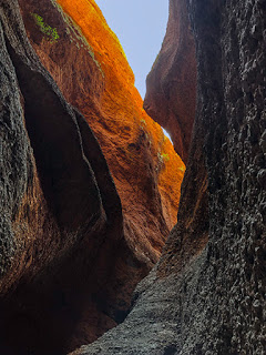
Cathedral Gorge
Part way along our walk the path divides leading to Cathedral Gorge, a place of outstanding proportions. Walking beside a deep but dry riverbed cut by rushing water, we followed a narrowing gorge with orange sandstone walls rising over 200-metres above us and climbing several sets of steel steps before the enormous scale of Cathedral Gorge was revealed.
Cathedral Gorge
It is hard to convey the scale of this place from a photograph – you really need to be standing here yourself to appreciate just how big this water cut gorge is.
You will certainly have seen it on TV or any Qantas flight where the heart tugging ‘I still call Australia home’ song is played from the gorge along with the entire Sydney Symphony Orchestra.
Echidna Chasm
The day was still young and following lunch we were off again, this time to the north and another hour on the gravel road. Our next destination is Echidna Chasm and what a remarkable place it is and absolutely worth the discomfort.
The path is a little tough on the ankles as it clambers over large river rocks and boulders beneath towering cliffs lined with Livistona trees. However, these cliffs were entirely different from the domes we had left behind. The entire area is comprised of conglomerate, a mixture of different size pebbles and boulders solidified in place by sandstone. Where exposed to oxygen it looks much like orange-coloured concrete and is almost as hard.
Cathedral Gorge entrance
The chasm quickly narrows and darkens with slits of light from above giving the upper reaches a warm glow. Several large chunks of rock have fallen but remain precariously wedged between the chasm walls and further in, just as it looks as though the way is blocked by huge rock falls, you can weave your way around them, up steps and finally arrive in a round amphitheater with unusually high humidity.
The return walk is just as impressive as you work your way closer to daylight and the dry heat of the sun. We hadn’t heard of this chasm before but so glad we got to see it.
Lookout!!
As we headed back towards camp on another long, rough drive, Steve had a treat for us. We stopped at Steve’s favourite viewpoint and what a impressive place it was with a 360-degree view across a valley with spear and spinifex grasses, ghost gums and orange cliffs glowing in the setting sun. The steep but short walk to the top was worth every step.
Kungkalanayi – Lookout
Dinner One last treat was waiting for us as we got back to camp. Included with the full-day tour was dinner, which tonight was three large pieces of eye fillet, cauliflower and broccoli bake, sautéed potatoes and two salads with apple pie and ice cream to follow along with the great company of our fellow tour group.
Of all the tours we have done on our trip so far, this one is right up there with the best. You do need to be quite fit, wear suitable enclosed walking shoes and can handle the rough drive and uneven paths, but it is worth every ache you’ll have the following day.