As today is predicted to be showery we decided to have a look at a few display homes to get an idea of what is in vogue in Queensland housing right now. But first, time for a coffee and pastry at Ma Boulange across the road.
Harmony in Sippy Downs
Harmony Show Homes – Sippy Downs
Just 30-mins drive southwest from Coolum Beach is the delightfully sounding ‘Sippy Downs’ a flat, almost marsh like area close to Mooloolah. Located here is a new display village very well designed and featuring both local and national builders.
By complete chance the first single storey property we looked at happened to be our favourite and one we returned to for a second look… and then took a brochure to look further.
Part of the reason for our big adventure around Australia is to look for somewhere to downsize and settle in the future and visiting display homes is a great way to get an idea of what style of house we would like. And today was a great start. A single storey home would suit us well as we get older but one thing we would really like is somewhere to store the caravan when not on the road and a large shed would be ideal. If it could also house a man cave, all the better, somewhere to store all those essentials in life… a beer fridge and a ride-on mower for example.
Minyama
Before we returned to Coolum Beach we had a drive through some of the neighbourhoods looking at new and existing properties and many waterside homes in Minyama, near Mooloolah.
One very interesting place is Mooloolah Island with just one narrow road but beautifully landscaped properties all with deepwater access. Sadly we had to rule it out – it would be difficult with a caravan in tow.
Back to Reality
We’ve decided we like Coolum Beach so much we’ve extended our stay to eight days giving us time, if the wind and rain clears, to explore the Glasshouse Mountains to the south of us. In the meantime, between showers, we took a windy stroll along Coolum Beach to the Noosa National Park boundary at Stumers Creek with just a brief stop to watch the clouds drift by before happy hour begins
It was windy with some heavy rain overnight but this morning we were greeted with sunny spells.
French Canadian Breakfast
We had seen a French Patisserie yesterday just across the road and decided it would be a great place for breakfast. And so it was with great coffee and the best French Toast I’ve had in years. And Catherine’s choice of pancakes looked pretty good too.
A lovely touch was the dusting of icing sugar in the shape of the Eiffel Tower.
And so, it goes without saying, Ma Boulange goes onto our recommend list. And I’m sure we’ll be visiting again before we move on.
Feeling slightly guilty (only slightly) it was time for a walk and our new neighbours suggested one of the coastal walks towards Coolum Mountain. They had walked to the top of the mountain but that would have needed more coffee stops on the way for us – we are on holiday after all!
What’s with all the noise?
From early this morning we heard what sounded like jet skis riding the waves but as we walked over to the beach we saw instead hundreds of surf club competitors and dozens of zodiac boats taking part in a competition. The strong wind was whipping up the waves, which would have added to the challenge no doubt.
Coastal Walk
Coolum Beach from the Lookout
We joined the coastal path and headed south towards Arkwright Point. Initially a boardwalk, the path is part tarmac, part gravel and part forest track with many off-shoots leading through scrub to one of the many timber constructed lookouts perched on the cliffs.
It’s any easy and rewarding walk with plenty of wildlife including several beautiful Rainbow Bee-eaters flying among the trees. Some colourful fungi too if you keep your eyes open.
The lookouts are a place of remembrance too with many plaques celebrating the life of lost loved ones.
Our walk ended at Arkwright Point with views along the coast to Mooloolaba and Maroochydore. Although we were about to head back to Coolum Beach the track doesn’t end there but continues both north and south as part of the Sunshine Coast’s 69km Coastal Pathway.
There is something about this place that neither of us can put our finger on but it is growing on us.
Cheers!
My nephew and his girlfriend kindly bought us a bottle of rosemary infused gin at Christmas, which didn’t last long enough on this trip but a chance discovery, at the local Dan Murphy’s, of a rhubarb and ginger infused gin has replenished our supplies… for now at least!
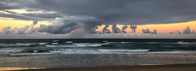
Distant shower – Coolum Beach
And so as the sun starts to set, and a fresh bottle of gin awaits, it must be happy hour.
Today is a relatively short travel day from Brisbane to Coolum Beach on Queensland’s Sunshine Coast. At just 120KM and mostly flat it isn’t much of a test for the car with the caravan attached but it is quite windy and that usually means caravan sway.
Much of the drive is on good, smooth roads for once and mostly dual lane motorway. But, with the exception of the enormous Gateway Bridge as we left Brisbane, the scenery was nothing special until we got our first view of the Glasshouse Mountains. Visible from miles away, the spectacular vertical columns of rock are the remains of volcanic mountains from around 26-million years ago. Unfortunately we could only admire the view from the road but hope to walk among the peaks sometime during the next week.
And before long we were rolling into our latest stay at Coolum Beach Holiday Park, right by the sea on one side and the shops and restaurants on the other. It looks to be a great location but not the easiest to reverse park. But with the experience of our Tow Training we managed to park without too much trouble.
Time to relax with a cup of coffee and explore our new environment.
Ocean Views
Setting Sun at Coolum Beach
As the sun was starting to set I headed over to the beach, just 100-metres away, to capture a few shots of the setting sun and clouds but got treated to a full moon rising at the same time. An awesome sight but unfortunately not one that the iPhone can capture well.
We’ve spent the past week in and around Brisbane in part to catch-up with friends and colleagues but also to see more of the region. I’ve made many work trips to Brisbane over the past 12-years but I’ve never had the chance to get out and about and explore the countryside.
Our second, and coincidental, reason for visiting Brisbane is to try and get the repeating ‘Restricted Performance Mode’ issue with our Land Rover Discovery investigated and fixed before we head further north. Jaguar Land Rover (JLR) have been doing the right thing in trying to get the issue resolved but it’s becoming a showstopper now and we can’t trust the car to head any further north, safely, where JLR dealerships will become fewer. So, the car is booked into JLR Springwood to see what they can find. Actually it has to be towed in. Land Rover Assistance requires the vehicle to be towed in order to authorise a loan car, a costly waste of money and time. But that is their process and we have to follow it.
The Scenic Rim
One of the trips we wanted to do while in the region is the Scenic Rim, a circular country drive taking in wineries, art galleries and produce growers as well as great views. The Rim is formed by the Great Dividing Range of mountains along the South East of Queensland and the North East of New South Wales. Situated an hour’s drive south of Brisbane, our drive takes in the townships of Peak Crossing, Boonah, Beaudesert and Tamborine Mountain.
Our first stop was supposed to be at the Flinders Peak Winery but it was a letdown. It’s not the easiest place to spot from the road and when you do find it it appears to be more of a B&B and cottage rental business. It’s only by following the narrow cottage access driveway towards a number of sheds and some parking signs that you get some idea that you haven’t stumbled onto someone’s farm. But even then there’s little obvious sign that this is a winery or even where the entrance is. It was only after we turned the car around and started to drive back to the driveway that we spotted any sign of activity, a couple of people in a narrow doorway with a couple of glasses of wine. Sorry guys but confusing access like this and poor signage just left us with a feeling of not being welcome.
We got back on to the main road and drove through further mixed, open countryside and dense forest. Certainly more rain has fallen here than Central New South Wales. Farm dams are full, grass is green and the trees look healthy.
A Boonah of a coffee
We were hoping for a good place to stop for a coffee and that happened to be at Flavours Cafe, a 103-year old cottage in the town of Boonah. The cottage is all that remains from a former office and butter factory. It was great to see large photographs of the buildings as they used to look during their productive years with cattle roaming in the fields at the front of the property and the once active train line. Now only the original office survives as the cafe and the road now carves its way across the old cattle field.
Excellent coffee by the way and the first in Queensland that wasn’t just hot milk with little taste of coffee.
In the distance were some seriously impressive mountains forming the Main Range and Mount Barney National Parks but unfortunately just a little too far for our drive today. Instead we doubled-back and took the winding, and appropriately named, Boonah-Beaudesert Road to…well, Beaudesert. Finally a good, smooth road and wide too. One of our frustrations so far has been the difficulty of finding somewhere to pull-over to take a photograph but luck was on our side when we spotted a large group of dead trees half submerged in a lake – quite a site. And the reason the trees were in this state was the construction of the Wyaralong Dam flooding a large section of the valley where the Teviot Brook used to flow.
Wyaralong Dam
We had a brief stop at Beaudesert and checked the transmission and engine radiator temperatures as a reference for JLR when the car is not towing. All appeared normal but as expected without the van.
Our main objective today was to explore Tamborine Mountain, not just a mountain but a destination and township. ‘Tamborine’ is derived from the Aboriginal name for the Finger Lime that grows throughout the mountain range. The mountain was part of a huge shield volcano and sits on the northern end of one of the largest erosion calderas in the world.
The road from Beaudesert was in need of some work and it looked like some effort was being made to improve it with several stretches reduced to one lane with traffic lights. But the road leading up to Tamborine Mountain was something else, definitely not one for the caravan. This road was narrow, steep in many places with switch-backs, sweeping bends and huge trees hanging low over the road. This would be a great drive in a small sports car such as Catherine’s Audi.
Skywalk
Just off from one of the many sharp bends was the Rainforest Skywalk. We parked and wandered in to the cafe/shop for some lunch but a coach party had pretty much cleaned them out. The Rainforest Skywalk is an aerial platform installed among the tree tops but with little information available at the centre, or online, it was hard to know how long the walk was and if it was worthwhile. But the decider was the price, $19.95 each, which seemed excessive. If you haven’t experienced one of these elevated platforms, and curious what it is like up in the canopy of trees, then it is worthwhile… as long as you have a head for heights.
Gallery Walk
Driving a little further along the road and we arrived at the Tamborine Mountain Gallery Walk, a mix of craft and antique shops, cafes, cellar doors and an over representation of ‘alternative’ therapists. We enjoyed a very pleasant lunch at the Mount Tamborine Vineyard and Winery before having an explore of the shops. Unfortunately being a weekday most of the art galleries were closed despite the number of tourists wandering around.
Hang Glider Lookout
We heard a good lookout point was not too far away at a popular hang glider launch site and it certainly impressed with dramatic views out to the west and the distant mountains forming the western range of the Scenic Rim.
Hang Glider Lookout
Sandy Creek
We were hoping to get a walk in today and we were heading in the right direction to the Knoll section of the mountain. The Sandy Creek track starts from a viewpoint looking out to the West but much of the view is obscured by trees.
Sandy Creek Walk
The track heads gently downhill through dense forest that becomes darker the further you descend. Quite abruptly the vegetation changes to a spectacular dense palm forest with the ground littered with fallen palm branches brought down by recent storms. At this level the rocky creek is gradually exposed as the path leads towards the Cameron Falls Lookout.
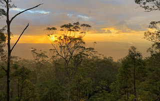
We were in luck with the weather when a brief shower passed over giving us the true rain forest experience and continued until we reached the lookout. Although there was just a small flow of water at Cameron Falls, the view out to the West was amazing with distant showers being lit by the sun and the buildings of the Brisbane CBD visible on the horizon.
Cameron Falls Lookout
As happens so often at mountain lookouts, some of the best views are obscured by growing trees and this one, sadly, was no exception making photography a challenge.
Sandy Creek
It was at about this time that we heard the distant calls of Black Cockatoos, always a sign of rain on the way, which prompted our uphill return path to the car. I’ve had the privilege to walk some great tracks in spectacular locations around the world and to me, this is one of the best walks I’ve done.
And the call of the Black Cockatoos was correct, down came the rain just as we got back to the car.
We had a good trip from Toowoomba yesterday and arrived in Brisbane before lunchtime and no issue with the car. That said it was a mostly downhill or a level drive on the freeway. We checked the transmission radiator when we pulled-up at the caravan site and it had reached 85C but we’ll be keeping a check when towing for a while to see if it is the transmission temperature that is triggering the Restricted Performance issues we’ve been experiencing.
Mount Coot-tha
Following rain and a windy night the sun was shining brightly this morning, which put us in the mood for a good walk. There are many trails in the parks around Brisbane but one place in particular was familiar to me and where I had often seen people hiking during work trips in the region.
Mount Coot-tha is Brisbane’s highest mountain named after the Aboriginal word ‘ku-ta’ meaning honey, produced by the native stingless bee. The mountain forms a bush reserve of approximately 1,600 hectares, primarily eucalypt forest, with excellent views of the Brisbane CBD as well as Moreton Bay and Stradbroke Island.
Brisbane CBD
The best views can be found at the Lookout, which is also served by a cafe and restaurant. And it was right here that we stopped to enjoy the view and grab a coffee before preparing for a bush walk.
Lichfield Track
We chose to take the Lichfield Track, which extends for 2.5KM through the eucalypt forest on a relatively level, well walked path following the contours of the mountain and never too far from the road that winds its way around the mountain. The weather was ideal today for our walk, not too warm and with little humidity, which made the walk easy going.
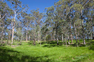
One of the few patches of grass
Being a subtropical forest it is mostly dry with hardy plants and grasses filling the gaps between trees. There was little obvious wildlife apart from the ever present Brush Turkeys and the occasional Cockatoo and Rainbow Lorikeet. There are snakes about though including the Eastern Brown, Red-bellied Black and the harmless (to humans at least) Coastal Carpet Python, one very large example I’ve seen here before.
Although largely dry there are occasional green areas that benefit from past clearings and forest fires.
It didn’t seem long before we had reached the end of the track at the appropriately named Gold Mine Picnic area. Gold was mined here for a number of years up until the 1950’s but it was far from successful. It was a good spot to relax, though, and watch the magpies and butcher birds searching for food. After a short break we headed back to the car and down the winding mountain road to the Brisbane Botanic Gardens, which turned out to be a real gem.
Japanese Garden
Trees of the World
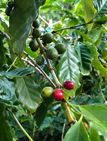
Brisbane Botanic Gardens is Queensland’s premier botanic gardens and it is easy to see why. It is huge, sitting at the base of Mount Coot-tha, and is crammed full of plants, trees and cacti native to Australia and many other countries around the world. You could easily spend a day wandering around the hills, lakes and exploring hidden gardens and still miss parts worthy of viewing. And, of course, we just happened to spot a coffee plant growing towards the top of the gardens.
Thoroughly recommended and an easy drive from around the Brisbane area.
Star Gazing
Adjacent to the botanic gardens is the Sir Thomas Brisbane Planetarium, named after Scottish astronomer and governor of the colony of New South Wales between 1821 and 1825.
A popular attraction for all ages, the Planetarium was unfortunately closed on our visit while a new digital projection system is installed.