Yellow Water Billabong Cruise – Kakadu

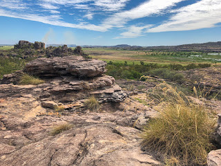
Today we’re heading to the wetlands of the Yellow Water Billabong and South Alligator River in search of crocodiles and wading birds. Now it’s a curious name Alligator River, and I have used the correct name, when there are no alligators. It could have been named pretty much anything else, Crocodile River for one but that would have been just too obvious. One possible explanation for this curiosity was an early settler to the region who arrived here from Florida. Another says his boat was called the Alligator. Either way it’s a pretty dumb name.

Australasian Darter

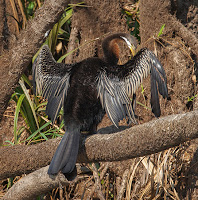
Our cruise started with an excellent guide, Martin, who mixed a good sense of humour with a lot of knowledge and it was very clear he was passionate about this double listed World Heritage site. And almost immediately we were spotting wildlife – catfish swimming past us and Batman spreading his wings. Well, Martin told us it was Batman but I’m pretty confident it was an Australasian Darter spreading its wings to dry in the sun.

Just around the bend of the river and there was Max, a huge male estuarine crocodile basking in the sun getting his blood temperature up ready for another relaxing day. He was so used to cruise boats that we nudged the boat right beside him. He didn’t seem to care. Either he was still too cold to make the effort or he was thinking, ‘just a little closer, come on, just a little more…’

Estuarine ‘Salty’ Crocodile

The cruise continued briefly and then more wildlife – an intermediate egret (great name by the way) magpie geese, another crocodile and another, hundreds of plumed whistling-ducks, a great-billed heron, another egret, a royal spoonbill. And trees too – freshwater mangroves, paperbark and pandanus and a few thousand royal lotus flowers. This place was teaming with life, and that was just above the waterline.

Each time Martin began to explain or describe something there was another creature to see. And everywhere we looked was green, lush and healthy. We were only a few months past the wet season and water levels were still dropping but it was hard to imagine this area ever being under a further two-metres of water and year after year at that. Few trees would ever survive such a soaking but the paperbark tree is one, a true survivor and the pandanus too. It’s no surprise that these are the dominant large trees in the wetlands.

Royal Spoonbill

The wetlands are dominated by grasses and they have a clever way of surviving the deluge of the wet season – they float! What looks like land you could walk on is anything but, step on it and you’ll be looking at fish, long-necked turtles and more likely something with rather large teeth.

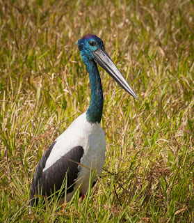
More crocodiles basking in the sun and then something a little special, one bird we had been hoping to see – a Jabiru. A huge bird with an enormous black bill. Sadly there’s a problem here. The Jabiru is also a South American bird and the powers to be don’t like two different birds having the same name, so the Australian Jabiru, the one the Kakadu township was named after, has been demoted from the cool names category and is now just known as a black-billed stork.

Jabiru – Black-billed Stork

In the distance was a water buffalo, not a popular animal here any longer – one we saw had recently been shot by Park Rangers and is now being closely guarded by yet another crocodile. Along the edge of the river, clambering over the lily leaves, was a tiny water bird, oblivious to crocodiles close by, with enormous feet, comically large feet, known as a comb-crested jacana. Now that’s a name to be proud of.

And just watching us on the branch of a dead tree was Australia’s second largest bird of prey – the white bellied sea-eagle. A magnificent bird with a massive 2.2-metre wingspan.

Turning around and heading back to the jetty and we were stopping again. There was another Jabiru, a male this time, more crocodiles, more intermediate egrets, lilies, jacanas, whistling kites and magpie geese flying overhead.

White bellied Sea-Eagle

I wasn’t too sure what we would get to see on this trip. There is less bird life than during the wet season but there was more than enough variety, more than we’d seen before in one place, more than we’ll likely see again for a long time.

There was just one large bird that we were hoping to see that we missed – the Brolga. Maybe next time we need to visit during the wet season.

Another great trip and an excellent guide, boat captain and coach driver too. Thank you Martin.

Yellow Water Cruises are run daily by Kakadu Tourism from the Cooinda Lodge. Bookings are highly recommended.

Arnhem Land

Despite all the TV programmes and photographs of Kakadu, I never expected to see so many trees. Not particularly big ones but there are reasons for that and they’re largely to do with bad land management – depending on your point of view. And despite the dry season I hadn’t expected everywhere to be so dry and with such low humidity, which is a bit of a blessing.

Our main adventure is actually just over the Kakadu National Park border. We’re heading into Arnhemland, a magical place rich in both culture and wildlife. We’re doing the Arnhem Lander Cultural and Heritage 4WD Tour with Kakadu Cultural Tours.

River Crossing

The adventure starts as we reach the Border Store on the edge of Kakadu National Park. Here is our first taste of a river crossing on the East Alligator River and we’re certainly at the right time of year in the right type of vehicle. The crossing is a man made weir named after Cahill, one of the early settlers who introduced water buffalo, and shows signs of those a little more confident of their skills and vehicles than they should have been. We saw two large 4WD cars just breaking the surface of the water and there were surely more never to be recovered.

Fortunately our vehicle was a large 4WD truck and the shallow water wasn’t going to claim this one as a victim. Beyond the crossing and we were in a restricted zone, Arnhem Land, an aboriginal reserve and National Park. Almost immediately we were in a different landscape and on a corrugated dirt road certain to dislodge any loose fillings. Trevor, our guide and driver, knew this road well and adjusted the speed to minimise the vibration.

Arnhem Land Escarpment

The landscape varied from open plains of grasses to wooded groves with the type of tree changing as we traveled further. In the distance was the Arnhemland Escarpment, the oldest rock in Australia, so old it contains no forms of fossil of any species including bacteria. At 1,500-million years old it is thought to have formed long before life took hold on this planet. And being comprised of sandstone, it had been a mountain tens of millions of years prior to that before eroding and settling as sand in an estuary.

White man doesn’t listen

During this time Trevor described the modern history of the region and the poor management of the land after the white man took over and introduced water buffalo. Partly for food but mainly for export, the water buffalo trampled the grassland, knocked down small trees and saplings and encouraged weed growth. 

Also introduced was uranium mining in an area known by the local mob as ‘Sickness Land’. They knew from their history that the areas starting to be mined made people ill. They may not have known about radiation from the uranium or the high levels of lead and mercury but they knew it was an area to be avoided. The mines and the buffalo grazing had a devastating effect on the aboriginal people, the animals they relied on for food who’s environment was being changed and the land they had lived on for countless generations, land they cared for and knew how to manage.

Around the time of the Land Rights campaigns, a local elder complained that the land was dying and discussions with the government ultimately led to a compromise – the government would create a National Park to protect the land but only if the aboriginal people agreed to allowing mining to continue with no more than three active mines at any one time. The compromise was agreed but that was the start of more trouble.

White man doesn’t listen… again

It has been known by the aboriginal people that burning the land in a controlled way benefited their food resources but also kept the growth of trees and grasses under control. Burning the spear grass created fresh new growth within days, which attracted wildlife and ultimately food for the people. They knew when to burn and what to burn and created patchwork burns to help prevent wildfires from lightening strikes causing large, hot fires that were too severe for trees to survive and worse, the hot fires also destroyed the seeds of the trees resulting in areas of no tree growth.

Low-level Burn-off

Ignoring the years of knowledge of the local people, the National Parks tried to protect the land rather than manage it. Lack of burns led to dense areas of saplings and combustible leaf litter and dry grasses led to hot fires, which killed not only the saplings but also the larger trees and seeds. Eventually things began to improve when the National Parks began to employ local people and the need for controlled burns was more understood. With the exception of some political parties, the need for controlled burns are well known and are now common practice throughout the country.

Trevor spoke about the paperbark tree as we drove through an area of rich grass and standing water. The tree has some remarkable properties. The bark is both waterproof and fireproof and the sap contains a natural antiseptic. Well known to us as the Tea Tree, the aboriginal people use the bark to make canoes, wrap food before baking in the ground, as a painting surface, for roofing material and as a soft blanket for babies. Being fireproof they can also light fires in their canoes for heating and cooking while out fishing.

Crocodile talk

Our first stop was beside a river where Trevor explained crocodile behaviour and safety. Knowing how crocodiles behave is a major key in being aware when near rivers or where crocodiles may inhabit. And just beside where we stood was evidence a crocodile had been here with telltale tracks in the sand – a male. Male crocodiles climb out of the water and turnaround facing the river prepared for any competing male. They probably get the nicest view too.

Arnhem Land Wetlands

Just a short stroll and we were in open wetland with views over to the ancient Arnhem Land escarpment and water birds, lots of them. Magpie geese, Jabiru, spoonbills… all among brilliant green grasses and flowering lilies. This was the scenery I was expecting. It was beautiful. Not to feel too comfortable in our surroundings, Trevor cautioned us about some of the other wildlife that calls this place home. Australia is well known for its venomous snakes and Arnhem Land and Kakadu are home to most of them. And another less than savoury but entirely man made issue is the Cane Toad, described earlier when we were in Bundaberg. Hundreds of tiny cane toads were just making their way from a small billabong near where we had parked. Fortunately these poisonous little creatures would soon be food for larger animals, including some snakes that have built up a resistance to their toxins.

Our next stop was at the Injalak Arts and Crafts Centre in Oenpelli. Like many aboriginal settlements it was a little rough around the edges with dogs roaming around. But the people were friendly as ever with big smiles. The gallery here is a major source of income and for once the artists weren’t being exploited. Each piece of art is priced in agreement with the artist who receives 97% of the sale price with the remaining 3% going towards gallery and administration costs. Unlike the overpriced artwork sold in the big cities, we were able to purchase at the wholesale price, which gave a very clear indication of the enormous markup galleries charge.

Benson at work at Injalak

We were guided around by Tony and introduced to the artists. It was quite an honour to see the skilled work in action and to be able to talk with the artists about their work and the meaning behind the style of painting. One favourite of ours, Benson, so named after the cigarettes he used to smoke, was extremely good at showing the technique he used and the steady strokes he had developed over 30-years. The painting he was currently working on was likely to take him 3-weeks from start to finish. Looking at the detail and delicate brush strokes it was not hard to understand why.

Examples of some amazing screen printed art, paintings on bark as well as weaving were also there to be seen as the artists worked on them. But then we stepped into the display gallery. It was like walking into another world, a gallery and shop to equal those in any city. The place was full of the work done by the local artists and at reasonable prices.

Craig with our Barramundi painting

We could have spent hours here admiring every piece but our eyes settled on one in particular of a Barramundi and unusual in having a grey background rather than the traditional red ochre. It was painted by local artist Craig and we were advised by the staff that he was somewhere around the gallery and would happily have his photograph taken with the painting. He was too. He took us to a spot with the wetlands and escarpment in the background and produced a big, proud smile for us. We were both very grateful to him and expressed our thanks and admiration for his work. We’ll never forget this experience and have vowed to send him a photograph when we have it mounted and displayed at home.

Lunch followed right next to the Arnhem Land escarpment but a big surprise was in store for us. Part of the tour takes you to see rock art but not like you will see behind protective bars or Perspex in National Parks. Here we were going to see a very special site. Trevor had assessed the fitment level of our group and believed we were up to the challenge of clambering up the escarpment to view some rarely shown rock paintings. This was something we both greatly wanted to see on our trip around Australia and were blown away with what we saw.

Ancient Rock Art – Arnhemland

It was quite a scramble but well worth the effort for the amazing view it provides across the wetlands and the escarpment into the distance. But just behind us beneath and along a rock overhang is some incredible ancient rock art. At least 20,000-years old, many of the paintings looked as if painted recently in amazing detail. Several generations of style were clearly visible including the X-ray style that this region is known for. Trevor explained how the images were created and how they are able to date some of them based upon known animals that have been extinct for thousands of years. Sharks and squid confirm the area once was a sea, kangaroos that no longer live here, barramundi, eels, snakes, echidna, wild pigs and, of course, crocodiles can all be seen here among many of the traditional Dream Time images.

And then it got better with more and older paintings and again at an area few get to see. Here, in intricate detail, were story lines with mother figures, serpents, yam-headed people and many more all described with so much knowledge by Trevor.

Arnhem Land Escarpment

The scramble back down to the truck was just as much fun as the climb but always looking around for anything hiding under the rocks and ledges, anything that might be startled and tempted to bite. We carry a snake and spider bite kit with us when walking in the bush but, of course, being aware of your surroundings and avoiding bites in the first place is always the better option and far less painful.

The rock art was the highlight of today and it is a tour that we cannot recommend highly enough.

More information on the tour can be found at www.kakaduculturaltours.com.au

Katherine Gorge – Nabilil Dreaming

From a photographer’s perspective there are four times at which it is best to see Katherine Gorge; sunrise and sunset during the ‘Wet’ and sunrise and sunset during the dry season. The ‘Golden Hour’, an hour after sunrise and an hour before sunset, produces the best light for landscape photography. In the case of Katherine Gorge the golden hour light transforms the near vertical canyon walls into glowing orange, reds and yellows against a deepening blue sky. And so it is no surprise that we have chosen an evening dinner cruise on the Katherine River through the Gorge.

Nabilil Cruise – Katherine River

We joined the rest of our cruise companions just beyond the Visitor Centre where we chose our dinner option and then were guided to our boat and our indigenous captain and guide, Jimmy. Immediately opposite the jetty was a crocodile trap, a good sign that saltwater crocodiles were known to call this river home. Crocodile safety was a feature of Jimmy’s introduction and dangling limbs in the river was not advisable.

Within a few minutes of casting off we got our first sighting of a freshwater crocodile as it lazed in the lowering sun. The ‘freshies’ are more colourful than their saltwater cousins with bright yellow/green and dark stripes. They somehow look less prehistoric too with their long, narrow jaws and are certainly less aggressive. Jimmy took the boat closer to the river bank to give everyone a closer look before it decided we looked more like prey and sunk beneath the ripples our boat was creating.

The first section of our tour is actually along part of a series of 13-pools created along the length of the gorge. Dam walls in the underlying riverbed are normally under several metres of water during the wet season but as the dry season takes over the river level drops leaving pools with some low level waterfalls for what flow remains. It is for this reason that the National Park Service are confident they can keep the pools free of saltwater crocodiles – once the pools are isolated the crocodiles can no longer move freely and are more easily trapped.

Dreamtime Creation

Jimmy explained the Aboriginal story behind the creation of Katherine Gorge and this pool in particular, which was named after the sound of the Cicada as Nitmiluk – Nit, Nit being the sound and Luk meaning the place of.

We were just approaching the end of the first pool and a large rock wall blocking the flow of the river. At this point a 400-metre walk takes us past 20,000-year old rock paintings and a great location for photographs of the gorge walls reflected in the water. And at the end of the walk is our second boat ready to take us further up the river.

Pool Two

Now the more observant may be starting to wonder how a large boat got to the second pool when it is isolated by the dam, surrounded by the huge walls of the gorge and no access by road. As Jimmy explained, it was a common question, and it relied on the high water level during the Wet. Each season a high powered boat tows the cruise boats against the current to their required location where they are lashed to the gorge wall in a way that later keeps them secure as the river level drops and the pools reform. At the start of the wet season they are returned on the rising river for safe storage and readied for the next year.

Sun setting over Pool Two

The second pool is also the location for canoe adventures, which are able to navigate further up the gorge. I’m not sure I would want to be part of the first trip of the season – have every one the saltwater crocodiles been found and removed?

By now the sun was starting to set and the gorge walls were beginning to glow in the light. The orange colour of the gorge is caused by rusting of the iron oxide contained in the sandstone. Below the surface, free of oxygen, the rock remains white.

As we cruised further upstream Jimmy explained the scientific version of the gorge’s formation. In the same way that the sandstone we saw at Edith Falls was created, the sandstone in the gorge is also fracturing into regular rectangular blocks. Over time the blocks break away and fall into the gorge to be ground down by the river. Unusual here, though, for a river path, there are none of the classic curves and bends, instead the river takes 90-degree turns along the fracture lines of the rock. 

After a few last sunset photos it was time for dinner and our final boat was waiting for us. This one had tables laid out with white tablecloths, native flowers and candles. As we set-off we were presented with a glass of sparkling wine with a red hibiscus bud and introduced ourselves to our table guests. An entree of smoked chicken, crocodile, kangaroo tail and salad was followed by Barramundi or eye fillet, a mango sorbet and flourless chocolate cake with a berry coulis.

Drifting along after sunset

As the stars began to appear we drifted quietly around positioning the boat for the best views with spotlights lighting the riverbanks while catfish swam all around us. It was such a peaceful, relaxing highlight to the end of an excellent cruise with good company and great food. Very much recommend. You can find out more about the Nabilil Dreaming Sunset Dinner Tour at Nitmiluk.

The drive back to the campsite was in darkness and staying well below the speed limit knowing kangaroos were likely to be around. And true to form our headlights caught a small grey roo right beside the road. Fortunately it chose to move back into the bush rather than run across the road in front of us.

Katherine – Edith Falls

42KM North of the town of Katherine in the Northern Territory sits Nitmiluk National Park, named after the aboriginal ‘Place of the Cicadas’, and home to Katherine Gorge and Edith Falls.

We’re visiting Edith Falls today, known more recently by its aboriginal name of Leliyn, which comprises several waterfalls between three pools of clear crocodile free water. Now I should clarify here for the less cautious, if you read the warnings about crocodiles in this area you may be forgiven for thinking there are no crocodiles, Salties or otherwise. Read the warnings carefully though and you may think again about plunging into that tempting creek or billabong. The information display near Edith Falls kiosk clearly states that a management plan regularly surveys the area, sets traps and removes any saltwater crocodiles found. It does not say there are no crocodiles. Still thinking it’s safe to swim?

Leliyn Trail

The trail then levels out through a mixture of scrub and Kapok trees before climbing again to the high point offering our first view of the top waterfall. It’s an impressive sight even during the dry season and we can only imagine what it would be like in the ‘Wet’.

First View

Our walk to the upper falls follows the Leliyn Trail, which starts from the car park and heads steeply uphill for 500-metres giving the first view of the lower pool. As usual, any photographer will be competing with the abundant trees and shrubs to get a good view despite the recent bush fire.

Thongs in the bush – seriously?

A brief stop for lunch and we were soon being passed by some very young children clambering over the rocks and boulders that lead down to the falls, and where were their supervising parents? This section of the trail is not for those without experience of scrambling, fear of heights or generally unsteady in their gait. There are sharp rocks, gravel paths, slippery surfaces and highly venomous snakes in this area, yet people seem to believe thongs and not enclosed walking shoes are appropriate despite all the warnings at the start of each trail. Still, I guess natural selection will weed these people out over time.

Edith Falls – Upper Pool

Swimming Hole

Being from the UK, where the weather isn’t always conducive to swimming in rivers, or safe for that matter, I still find it hard to understand why people are allowed to swim within National Parks. Why?

Well, with such a pristine an environment as this and the conservation efforts that help keep it that way, humans carry germs and viruses on their skin and that’s not to mention the young ones in the water today in nappies. Not only that but as many a landscape photographer will tell you, scenery is for looking at and not for clambering over and dropping litter.

Mid-Pool

A case in point of the need to conserve this area lays with some of the flora found here and only in one other place – Southwest Australia.

The upper pool waterfall is a thing of beauty even during the dry season as we visited but it’s also full of people swimming in and around it. If ever there was a need for Photoshop this was it. And fellow photographers will know exactly what I mean.

Two further footbridges lead over the river to the opposite bank where a steep scramble leads to a viewpoint looking downstream to the second pool. You’ll hear the sound of a waterfall but it is obscured by rocks. Continuing a little further and the walk levels out with a second viewpoint signed Bemang Lookout at a junction in the path. We heartedly recommend this 40-metre detour for the view upstream and of the waterfall, obscured at the last viewpoint, but which also takes in the top waterfall and pools where we earlier crossed the river.

Tawny Bladderwort

The remainder of the walk starts a gradual decent with views across to the distant hills. Finally dropping down into the valley and alongside the first waterfall and pool, which we had barely seen through the trees when we first started the walk. Here easy access to the water is provided with canoes available to rent and a campsite and cafe. It was while we were here waiting for an ice cream that I noticed something moving among leaves near the path. Our first snake and a venomous one too! It was a black whip snake about 1.5-metres long and searching for food oblivious to us standing nearby taking photographs. It eventually moved across right where I had been sitting and off towards the campsite to spread a little excitement.

Black Whip snake

A local aboriginal man spoke about the snake and advised lookers on that it was safe and not aggressive but a bite would be potentially fatal for a young child or aged adult likening it’s bite to that of pouring battery acid onto an open wound. A couple who had just completed the same walk as us had earlier seen what appeared to be a king brown snake with its coppery coloured scales.

A Balancing Act

On the way into the National Park we noticed several large boulders balancing on top of each other. These were very similar to the balancing rocks at The Devils Marbles, also known as Karlu Karlu, that we had planned to see but which would have been a long diversion on our route. We were also earlier advised that it was very busy there and difficult getting a space to camp overnight. So, on the return leg, leaving Nitmiluk, we pulled over to photograph the stones and we appeared to be the only ones taking any notice of them.

Balancing Rocks

Much of this region is composed of sandstone but of a type unlike any I had seen before. Most sandstone is grainy and breaks apart easily. Here the layers of sand from a former inland sea have been compressed to such an extent over millions of years that the grains have fused into an extremely hard, glossy rock. The crystal structure that has resulted leads the rock to weather into square blocks and eons of rain and wind eventually round-off the corners leaving almost circular ‘balls’ left balancing on top of each other. The precariously placed rock in this case was over two metres wide.

Now, if you were to stand here long enough, and it will likely take quite a while – be patient, you may witness the rock finally topple to the ground to become just another boulder scattered across the bush. And then all the magic over millions of years that produced this balancing act will have been lost for all time.

So, pull-over, stop, admire and take a photograph before it’s too late. You may even be the person that photographs the rock as it teeters and falls. Or, less fortunately, the one standing a little too close for a selfie, the one wearing thongs.

Mataranka

At last, we’re staying at one location for more than an overnight stop. We have arrived at Mataranka, a small township on the edge of Elsey National Park.

Our camp for the next four nights is the Little Roper Stock Camp, a rustic, dusty campsite but with plenty of shade from the heat of the sun. It’s a friendly place with an evening campfire and fresh bread baked daily to order by Des. There’s nothing like a fresh, crispy loaf and the smell of baked bread in your caravan in the morning… other than a freshly brewed coffee of course!

Johnny Cakes are also available at 8am by the campfire. These date back to the 16th century in the UK but also popular as Journey Cakes during the American Civil War. They are simply flour, salt and water mixed and formed into a pancake shape and cooked in shallow oil.

Bush Walks

We’re here to do some bush walking and also for a dip in the hot springs, which this National Park is known for.

Botanic Walk

Our first short stroll was around the Botanic Walk, which starts from the roadside carpark and forms a 1.5KM loop. Many of the trees and shrubs are identified with their scientific name as well as the aboriginal name and what they used them for. Leaves crushed to make soap, lemon scented leaves for cooking with fish, sandpaper leaves for smoothing spears and tree trunks carved with stone tools to create canoes. Also many paperbark trees whose bark peeled, dampened and used to wrap fish before placing them over hot ashes. Trees even used to identify the time of year – in this case flowers bloom just as crocodiles begin to lay their eggs, a local delicacy.

Be Croc Wise

Our second walk for today, at 4-Mile, leads along a gravel track to the river and a boat ramp. This was our first view of the Roper River. Now around here you may be tempted to jump in to cool-off on a hot day. The water is certainly inviting, fresh and cool with some beautiful trees lining the river banks. There are, however, a few hazardous things in the river  – submerged trees for one and one or two crocodiles – both Freshwater and Salties. The freshwater crocodiles keep to themselves but the saltwater variety, well, best to leave them well alone. As such, swimming and canoeing are no longer allowed in the rivers. Needless to say we didn’t get too close to the water – we still have many places to visit on our trip where limbs are quite useful.

Mataranka  Falls

Termite Mounds

The following day we set-off for a longer walk, which forms part of the 16KM trek alongside the Roper River. Starting at 12-Mile Yards, an old cattle stock pen, our walk started off badly through what can only be described as sand. The track is bone dry and comprises a mix of gravel, very soft sand, dust and a few patches of rocky outcrop. It’s hard going where the sand has settled into long hollows but eases further into the walk. A few glimpses of the river between cabbage palms eventually brings you to an opening with a good view along the river, which has formed along a natural fault line between limestone and the deep red sandstone.

Each kilometre is a marker and well signed way-posts help keep you on the right track. Both sides of the pathway have many trees and shrubs providing some shade but the most striking thing is the number of large termite mounds, some reaching up to two metres high. These industrious creatures are vital in this environment. The termites eat grasses and hollow out trees as well as lifting many types of mineral to the surface. Once the colony dies the minerals are slowly released as a fertiliser preventing the ground from being leached each year during the wet season. The termites are also a source of food for birds, reptiles and frogs. The hollowed out trees serve as nests for parrots and provide the base material for the aboriginal didgeridoo. Not quite as destructive as we are led to believe.

Wild Cotton

Every so often I noticed what appeared to be clumps of white fluff along the path. We soon found the source – several wild cotton plants. We have seen some cotton plants growing in Queensland but this was the first in the wild.

After a few creek crossings where aluminium bridges had been placed, the path opened out into a sparsely vegetated rocky outcrop in the full heat of the sun. But eventually, after scrambling over limestone rocks and tree roots we could hear the waterfalls but we couldn’t see them.

Mataranka Falls

We weren’t expecting too much having seen photographs previously but we were left wondering where the photos had been taken from. All along the riverbank, where the falls were, trees and long grasses obscured the view. Only a few spots gave a glimpse and each of these were right by the water in low lying areas – ideal for crocodile access.

For the moment we carried on to a small campsite for lunch where we met a lovely lady from Tasmania. She had already tried to find a better viewpoint from the high ground and saved us the effort.

On our return leg I built up the courage to get closer to the water and quickly took a few photographs while keeping a close eye on anything that may be hungry. It was now hotter even hotter and our return trek on the 8.4KM walk was interrupted only by a few shady spots and a drink of water. I would hate to think how hot and humid it would be here during the summer. And how wet too, much of the area shows signs of flood where the wildlife is more likely to wander further afield. A great walk but there is better to come.

Bitter Springs

Mataranka is rightly famous for its thermal springs. Water filtered by the limestone hills of the Barkly Tablelands and bedrock works its way to the surface carrying with it heat and a rich supply of minerals, especially calcium. Mataranka has two popular springs, one at Mataranka Homestead and the other, far more natural and our choice, at Bitter Springs just a few kilometres from our campsite.

Bitter Springs

The water is a very pleasant 33C, extremely clear and free flowing. From a carpark a short concrete path leads to the start of the defined swimming area. From here a ladder drops you into the spring and you simply relax and let the slow current take you along several hundred metres of beautiful forest to a ladder and bridge, which marks the return path to the start. Although busy on our visit, the current keeps people moving along so it doesn’t become crowded. Sadly I appear to have started with a chest infection so only Catherine got to enjoy a swim.

Today marks our third month on the road and it’s hard to imagine returning to a more normal life in suburbia with traffic and road noise.

Tomorrow we set-off again a little further north and another Northern Territory adventure, this time in Katherine.