El Questro Gorge Day Tour

An early start today for an organised tour of El Questro Gorge, Zebedee Springs and an afternoon river cruise on the Chamberlain River.

Our guide, Emma, takes our group of four by 4WD 30-minutes along gravel roads and water crossings to reach the start of the El Questro Gorge trail. It’s only 8.30am and pleasantly cool as we start the rough track through savannah woodland towards the start of the gorge.

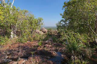
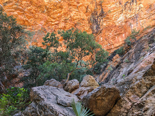
Like much of the surrounding 1-million acres of this remote wilderness park, El Questro Gorge is comprised of King Leopald Sandstone, 1.8 billion years old and predating multicellular life. It is an extremely hard form of stone, which splits easily into square blocks before tumbling down into ravines, gorges and valleys. It is responsible for much of the layered hills and escarpments typical of the Kimberley.

Livistona Palms

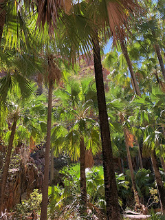
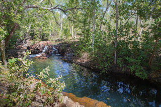
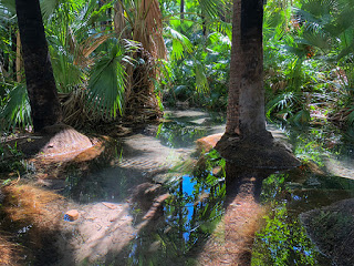
Here, over tens of thousands of years, water has penetrated cracks in the rock creating the gorge and its micro climate shaded from much of the intense sun. It is full of life. Towering Livistona trees line the creek that flows from the gorge backed by bright orange sandstone cliffs. Ferns thrive in the shade and provide habitat for small lizards, insects and frogs. Harmless Golden Tree Snakes are common but recent sightings of the highly venomous Death Adder means keeping a close eye on where you place your feet.

Emma showed us the unusual trick played by Spear Grass during the wet season. Water causes the seed spikes to twist around and dig into the soil. It’s a peculiar sight to see a plant moving of its own accord. But then this is a country of extremes and diversity and it takes this type of unusual action to survive.

Ochre Demonstration

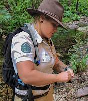
A little further on Emma reached for three stones hidden among tree roots by a pool. She had collected samples of ochre used by aborigines for rock art and ceremonial body paint. Orange, yellow and white ochre are rubbed against stone to produce a fine powder, mixed with water and painted directly onto rock or their skin. Charcoal is the final ingredient and is used to produce a deep black completing the four colours used in the aboriginal flag.

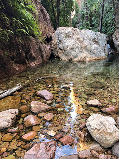
Deeper into the gorge we came to an abrupt stop where an enormous boulder had fallen reaching out to both sides of the gorge wall and blocking any further progress. A small waterfall fed the clear pool where we stopped to take a few photographs before heading back the way we came.

El Questro Gorge

It is definitely a walk requiring suitable shoes or boots for clambering over rocks and boulders and a walking pole is recommended.

Morning Tea

A short drive takes us to a pleasant riverside rest area where a few brave people were having a swim and the less brave took to the riverbank fishing for barramundi. Beside us stands, if that is the correct word, an enormous boab tree hit by lightning during the last wet season, which literally blew it apart. Boab trees store a lot of water and the lightning strike would have instantly turned the water to steam ripping the tree apart from the inside out. What remains is a mass of fibrous sheets, each being similar to the rings of a tree. An unusual feature of the boat’s survival technique – just beneath the bark of a living boab is a layer of green cells used by the tree allowing it to photosynthesise meaning it isn’t entirely reliant on its leaves – a good thing following a bush fire.

Morning Tea today is apple or orange juice and a tasty slice of cake. Too hot for anything but a refreshing cold drink.

Zebedee Springs

Another drive takes us to a series of thermal pools known as Zebedee Springs. Normally open until just midday with the afternoon reserved for guests, such as ourselves, of El Questro. We arrived as people were starting to leave, which meant we will have the place to just the four of us. Perfect. Now I may finally be able to get a photograph without the crowds.

Zebedee Springs

Just a short walk with a couple of boardwalk water crossings and we’re surrounded by palms, rocks and orange cliffs within a narrow gorge. It’s spectacular. This is the kind of scenery we were hoping to see and Western Australia has excelled. Some have likened this gorge to a place you would expect to see dinosaurs roaming about, they are not wrong.

Running through the gorge is pure, clear water. But this water sits between 28 and 32C. Rising from deep within the earth the water brings warmth and minerals along with it providing nutrients to the rich flora that flourishes here. Much as I am apposed to using beautiful places like this to swim, at least the numbers are controlled and it isn’t a National Park.

Thermal Pools

Lunch Time

The day was still not over and Emma was driving us back to our camp for our lunch of grilled barramundi and beef, included in the full day’s tour. We were joined by a very tame, and probably very well rehearsed, visit by a Kookaburra happy to pose for photographs.

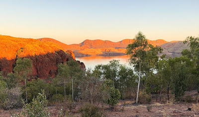
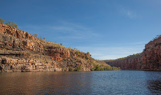
The afternoon adventure was another drive but this time over to the Chamberlain River. Now we were starting to see the true extent of this property with countless group campgrounds leading from the dirt road into the bush. Our driver and guide, Silvia, took us to the jetty where we boarded our cruise boat and set-off down the river.

Before long we had spotted a rock wallaby well disguised on a ledge in the cliff and then a freshwater crocodile basking in the sun. There was plenty of life in the water too, as we later found out, and not what you would expect.

Attack of the Archers

At the midway point of the cruise where are path is blocked by rocks pushed downstream during the wet season, we stopped and were quickly surrounded by many species of fish. Large catfish, seven spotted archer fish and barramundi hiding somewhere just out of sight. Vinnie, our skipper, handed out fish food and suggested holding it over the water. Was he expecting the fish to jump out of the water or was he getting us to lose a limb to a crocodile?

Chamberlain River

All of a sudden spouts of water were shooting out of the water and all over us. These were archer fish and they had learnt to shoot a jet of water at insects hanging on to tree branches and knock them in to the water. They have an amazingly accurate aim even allowing for the diffraction of vision through water. It had everyone on the boat laughing as we continued to get wet, though that may have been helped by the sparkling wine!

As we made our way back our eyes were searching for more creatures and a bottle of bubbly was on offer for the first find – or $5 donation to the Royal Flying Doctor if it was the same animal we had spotted before.

Another great tour and a great introduction to the Kimberley. Again highly recommended. More details available at www.elquestro.com.au

El Questro

We bought our Land Rover Discovery 5 for its ability to go off-road and to tow our Jayco Silverline Outback caravan. Today was the first time we put the combination to test on the gravel access road that leads from the notorious Gibb River Road to El Questro where we’re staying for the next three nights.

Now for those not familiar with the Kimberley and northern WA in general, this region of the country is often referred to as Australia’s last great wilderness and it has the remoteness and dirt roads to prove it. Our drive into El Questro was supposed to be on a relatively good road but here ‘good’ should be used only as a comparison to very bad roads. Severely rutted enough to shake fillings loose and scramble eggs, the road contained just as many loose rocks as a landslide.

Where’s the Grader?

According to a sign at the start of the 14KM track the road was in the process of being graded to flatten out the ruts. I can only assume the grader was taking a holiday elsewhere. But this car and caravan were designed to handle this kind of torture even if we, with our ageing backs, were not. Then added in to the mix were the inconsiderate drivers going in the opposite direction as fast as they could creating clouds of dust that forced us to slow even further until we were able to see again. The challenge of cornering on a loose surface with a large vehicle in tow was soon mastered and then came the first of two water crossings.

Water Crossings

Some person we had met earlier had advised us that the crossings were dry. Clearly they had been nowhere near here. It hadn’t rained for months but there was certainly a lot of water and loose, hidden boulders in the first crossing. Still, no problem, we have a high clearance caravan with independent suspension and a 4WD car that can handle a wading depth of 900mm. So, into 4-wheel drive, high clearance and auto traction control and off we went with ease until halfway across… and we stopped. For some reason the auto mode decided we were going downhill and switched to hill decent control. Never a good think to stop in water, I quickly switched to manual control, rock and gravel mode and off we went  again for the remainder of the crossing and up the ramp back onto dry land.

More rough road, more inconsiderate drivers and then the final water crossing. This one three times longer and looking twice as deep. In we went, still in the same 4WD mode and an oncoming driver decided he was going first. Eventually he realised he was in the wrong and backed-up, something we could not have done and the crossing was wide enough only for one vehicle. With a small wave in front and to the side of us and the sound of rushing water coming up the doors, we sailed through without issue and up the bank onto the final stretch of road into El Questro and the Black Cockatoo Camp Ground.

The car and caravan had proven their worth easily handling the challenging conditions even if they were both now coated in a layer of grey dust and about to get a covering of red dust at the camp.

El Questro is an enormous property covering 1-million acres and home to many outstanding natural features, gorges, rivers, fauna and flora – the very reason for our visit and the effort it took to get here.

El Questro Sunset

Tonight is pizza night at the outdoor camp restaurant and after a beer or two, the rest of the day is set aside to relax and rest our aching joints ready for the adventures that lay ahead.

Lake Argyle

Three times the size of the UK and with a population less than 40,000, the Kimberley in Western Australia is one of the oldest regions on earth.

Sunset from Lake Argyle Resort

We’re staying at the edge of Lake Argyle, an enormous man-made reservoir, in the northeast of the Kimberley.

The Lake Argyle Resort sits just above the lake giving views across the water to many of the lake’s islands, bluffs and sandstone hills, which light up at sunset and sunrise. Just how many campsites can provide a view like this in such an unspoilt and remote location?

There are plenty of things to do here for the adventurous and those who prefer to relax by the infinity pool soaking up the sun. Walking trails, 4WD-adventures, helicopter flights, boating, fishing…

Bush Walks

What better way to start exploring our new location than a bush walk to a viewpoint high above Lake Argyle.

Our walk starts directly opposite the campsite and follows a steep, winding path up the escarpment. Tall, dry grasses line the rocky path with sparse trees and shrubs baking in the heat from the sun. It all feels as if one small spark could set the entire escarpment off in a raging blaze.

Lake Argyle and the Ord River

The effort of the climb is rewarded, though, with magnificent views of the lake and its islands as well as the view back along the Ord River as it flows towards the town of Kununurra. Clumps of bright green grasses dot the hillsides providing contrast to the ancient orange sandstone. And at the head of the river is the Lake Argyle Dam wall. Not huge in the grand scheme of things but impressive in the volume of water the wall is holding back.

To gain a better view of the dam I dropped down from our viewpoint and followed the road down to a lookout just above the dam’s wall and hydro station. From here you get a better view of just how steep the dam walls are and it’s method of construction comprised almost entirely of loose rock and boulders with a compressed core of clay. It’s loose construction was designed to be flexible enough to cope with earthquakes, common in this region of Australia, something that a concrete dam is more prone too. It is especially important in this case as it sits right on top of a fault line and an earthquake in 2016 proved its worth with no damage recorded.

Since construction was completed in 1971 the 98-metre high wall has dropped just 4.5-centimetres due entirely to natural settlement.

Just two-years following completion, heavy rains in the wet season filled the dam to flood level with water pouring from the emergency spillways. They continued to flow through to 1984. In 1996, following concerns of sediment reducing the dam capacity, the spillways were raised by 6-metres doubling the capacity of the lake and plans are in place to increase the level yet further.

Sunset Cruise

Our main trip today, though, was a sunset cruise on the lake, something we had both been looking forward to. Starting from the campsite car park, a coach takes you down and across the dam with a guide explaining the history of the construction project and the attempts at farming in the area. Surprisingly the hydro station was not added until the early 1990’s, 20-years after the dam was completed though provision had been made for it during the original construction.

Freshwater Crocodile

Our cruise aboard the Kimberley Durack took us from Bamboo Creek southwards to an area popular with swimmers. Immediately behind their moored boats was some of Australia’s oldest know rock approximately 1.5-billion years old. That is long before any known life form existed on the planet. The cruise then continued around the headland towards crocodile bay, named after, not surprisingly, one of its many inhabitants.

Crocodiles

The lake is home to somewhere in excess of 35,000 freshwater crocodiles. It seems an excessive number, calculated at night using torches to pick out the reflection of their eyes, but this is a lake of excessive proportions. Measuring 703-square kilometres (271-square miles) and a catchment area forty-six times larger, the lake holds 10,763-billion litres of fresh water. That is the equivalent of 2.5 cubic miles with an outflow capable of supplying the entire country’s annual water needs every 3.5-hours.

Wallaroo and Joey

And not surprisingly, sat sunning themselves in the bay, were several freshwater crocodiles. They are timid creatures with a narrow snout designed to catch fish and pose little threat to people. Our cruise guide, Grant, pointed out that they don’t believe any estuarine (saltwater) crocodiles exist in the lake based mainly on the distance of the inflowing rivers from the sea to the north. But with that volume of water who knows?

The cruise then took us past a distant view of the opencast Argyle diamond mine and towards the lake’s largest island where several unique and well camouflaged wallaroos gathered on the shoreline to feed. One female was carrying a young Joey in her pouch but was quite happy with our presence as we all gathered to take photographs.

Yes, this really is a lake

Further into the lake and the scale really started to show. Right in the very distance were rocks at the eastern edge of the lake – over 20KM away, and that was just one small section of the most northerly region of the lake.

With the sun getting lower in the sky, the cruise moved on to a clear area of the lake where everyone was free to jump in and swim or just float around with a pair of noodles and a glass of wine or stubby of beer in their hands. Below them was 23-metres of clear, mostly crocodile free, water.

Catherine enjoyed a dip where the water was a little warmer than expected but still ‘cool’. As for me, I kept a lookout and helped supply those less wary with drinks and nibbles.

Setting Sun

Finally we started to head back as the sun faded behind the hills and put on a light show worthy of any we’ve seen to date. All we needed were a few more clouds to add colour to the sky, but those, as we’ve found over the last two months, are quite a rarity during the dry season.

Lake Argyle Sunset

It was another great trip and highly recommended. Just remember to bring along your swimmers, thongs, suncream and a can of crocodile repellent spray.

More details at: www.lakeargyle.com-cruises-tours-activities

Litchfield National Park

We have been visiting Litchfield National Park in the Northern Territory this week while staying just outside the park in the small town of Batchelor.

Views are very restricted as you head into the park with thick forest on both sides of the road for many, many kilometres. Only a brief glimpse in a burnt area of woodland gives you any view, indeed any idea where you are. You see, Litchfield N.P. is an enormous forest broken only by a few settlements, stations, gorges and rock escarpments. Without GPS, or a very good sense of direction, it would be very easy to get yourself lost here. There are also very few places to pullover safely even if there was something you wanted to take a closer look at.

Magnetic Termites

Giant termite mound

Our first visit into the park took us past some enormous termite mounds, by far the largest we had seen yet. But nothing could prepare you for those at the ‘Magnetic Termite Mounds’. Here two types of mound were standing tall but very different from each other. The magnetic mounds were being created by a species of termite that can tell where the magnetic north is and the narrow mounds they build align north to south. This means the mound shows the least exposure to the midday sun keeping the mound as cool as possible.

The second form are built like skyscrapers with huge towers and buttresses rising over 5-metres above the dusty grassland. Some, including the so called Cathedral Mound are believed to be over 50-years old and still growing – often taller than the surrounding trees.

Florence Falls

Continuing along we drove to Florence Falls for a hike along Shady Creek walk. From the car park the path quickly leads to the first lookout on a supported gantry overlooking the creek. It’s an impressive view of the Florence Falls even at this time of the year with plenty of water cascading into the plunge pool below. A steep set of steps, all 160 of them, then leads down to the creek through savanna woodland and then the cooler monsoon forest with its shady palms and stream.

Florence Falls

Unfortunately this is yet another beauty spot spoilt by people swimming in the plunge pool so any chance of a decent photograph was out. A very noticeable film of oil was floating on the surface of the water most likely from suncream, which, by the way, contains toxins. Why the National Parks in the Northern Territory encourage this I do not know. Surely the point of National Parks is to protect the fauna and flora for future generations. Allowing suncream to leach into the water is bound to have an affect on fish and other aquatic life and then on those animals that prey on them in turn.

The walk follows the creek upstream for about 500-metres before climbing out of the shade back into the savanna woodlands. From here the walk can then be extended to Buley Rockhole, which is an option we took but it was tough going in the heat with a heavy camera bag strapped to my back.

A few plunge pools lead from the track and I have to admit they did look inviting. We just took a few photographs of the shallow falls feeding the pools and continued on our way to the Rockhole.

A few people were already at the Rockhole by the time we arrived sitting on the rocks spoiling the view for everyone. Here the water tumbles down a few small falls through rocky pools before dropping into a deep pool and disappearing into the wooded creek. It was now getting hotter and there was little shade.

The remainder of the 4.2KM track doubles back following closely by the road to the car park. Waiting for us there was a shaved ice kiosk, which was a great welcome after the heat and sun. You could choose from a dozen flavours, or mix them, but all would be just as refreshing.

Wangi Falls

Our second trip into the park took us 42KM west and close to the park boundary. This was Wangi Falls and was to provide us with the best experience of the park.

Wangi Falls

We arrived early enough to get a shady parking spot, something of a rarity this time of year even though the school holidays in NT were over. Our walk starts from the car park and heads down to the huge plunge pool fed by two high waterfalls from above a vertical rock face. It would be a spectacle during the wet season but was just as impressive now with the rock face in shade and the nearby trees glowing bright green in the sun.

Again the swimmers were present but at least keeping to the shallows near the footpath… for now. Apparently it is a popular spot for freshwater crocodiles too though signs say it is safe to swim. This early in the day the sun is pointing towards you and the contrast and flare make it very hard to photograph. No lens hood or hand waved in the air seemed to help. We decided to try again after our walk once the sun was a little further around.

A boardwalk took us through swampy ground around the edge of the lake to the start of the climb, which winds its way steeply through a mixture of monsoon forest over a steel staircase to a viewing platform. Anyone hoping for a view from the treetops will be disappointed. As seems so often the case in the National Parks of the NT, the trees have grown beyond the viewpoint so all you get to see is trees. Surely there are enough trees around to trim a few and make a viewpoint worthwhile?

Top of Wangi Falls

Eventually the steel steps finish and rock steps continue the climb to the top of the waterfall. Access to the top of the falls is restricted in recognition of an aboriginal ceremonial area. Instead a short boardwalk leads over the streams feeding the falls with a fair view looking over to the distant forested hills.

The path then makes its way to the source of the second fall before heading back down through steep steps passing several small waterfalls along the way until reaching the plunge pool on the opposite side of the upward climb. And as for waiting for the sun to move further around to get a better photograph, we gave up. The pool was now full of people swimming with brightly coloured noodles including directly under the falls. Now, if only there were still a few crocodiles left over from the wet season.

It’s quite a tough walk, especially in the heat, and certainly not suitable for those wearing thongs, as we saw again today, but it is worth it even if you don’t get to see much of a view for all the effort. At least there is a cafe waiting for your return for a much needed coffee and piece of cake.

Drones ‘Permit’ted

Interestingly, the Litchfield N.P allows the use of ‘drones’ by permit holders unlike all the other parks we have visited in the Northern Territory so far. It’s also probably the least likely place you would want to fly one. Obeying CASA rules, you cannot fly over gatherings of people or within 30-metres of anyone. And helicopters are flying pleasure flights low over the falls, which rules out any drone flights.

Darwin Aviation Museum

Being so close to Asia made Darwin the target of the Japanese during the Second World War. The largest single attack on Australia from enemy raiders, more aircraft and more bombs were dropped on Darwin than the surprise Japanese attack on Pearl Harbour. In just one day on February 19th 1942, over 110-tonnes of bombs hammered the city, ships and airbases in two raids in an attempt to prevent Australia’s wartime allies using the region in support of the Pacific War. The raid killed 236, wounded nearly 400, destroyed 30-aircraft and sunk 11-ships at the cost of just 2-Japanese pilots.

The Darwin Aviation Museum has many items from the attack on display including Japanese aircraft wreckage and some rare amateur footage of the attack.

Boeing B-52 Stratofortress

By far the most impressive item on display, by a very long way, is the enormous US Boeing B-52 Bomber around which the museum is built. And I mean around. The wingtips only just clear the museum’s hangar walls and the tail almost touching the pitched roof. This is one enormous eight-engined aircraft.

With a wingspan of 56-metres it dwarfs every other aircraft on display including the huge General Dynamics F-111 supersonic bomber relegated to a corner of the hangar and a 1960’s era Sabre fighter, which sits under the B-52’s tail.

First flown in 1952 the B-52 Stratofortress was the American bomber designed to deliver nuclear payloads during the Cold War as part of SAC – the Strategic Air Command on 24-hour alert with aircraft constantly in the air.

B-52 Vertical stabiliser – 14.5-metres tall

This particular aircraft was recently retired and presented to the City of Darwin as a gift. The B-52 is still in service at bases around the world including Guam and is a regular visitor to Darwin. We were advised one was shortly to takeoff from the airfield behind the museum so we were keeping an ear out for it, not that you were likely to miss the high-pitched whining from its engines on take-off nor the trail of smoke it leaves in its wake.

General Dynamics F-111 Supersonic Bomber

No Barriers

One of the great things about this museum is the lack of barriers. You are free to touch the aircraft, take photographs anywhere and on regular occasions, climb into the cockpits. The F-111 is the only one with a chain fence but that’s more about public safety.

Sadly the cockpits for all the aircraft including the F-111 were closed today but you could still climb up and peer inside at the tiny space the pilots had to fly in. And in complete contrast the B-52’s bomb bay doors were open to view and big enough to swallow two coaches with room to spare.

B-52 Cockpit

The museum houses many early piston and jet engines including the famous Rolls Royce Merlin Engine used in the Spitfire, Mosquito and nearly all the Lancaster Bombers as well as the Rolls Royce Derwent jet engine based on Sir Frank Whittle’s original design, which powered Australia’s first jet powered aircraft – the Gloster Meteor from 1946 to 1963.

There are many more aircraft both large and small to view, helicopters, microlights and a bone yard of sorry looking aircraft outdoors. It’s an interesting place with some unique aircraft and a wealth of information on the Japanese raids on Darwin.

We missed the B-52 take-off but a few days later I saw another B-52 climbing slowly over Darwin through my rearview mirror. Quite a sight.

For more information check: www.darwinaviationmuseum.com.au