A site of significant importance to the local aboriginal people, Cape Leveque is a place of seemingly staggering beauty. Bright red cliffs fringed with white sand and an azure blue sea combine to make this location one of the most stunning natural sights you’ll ever see.
The spectacular cliffs of Cape Leveque
Cape Leveque has been on our must see list since we started planning our Big Lap of Australia. It is very remote and accessible only by 4WD vehicles or aircraft, which means it is off the day-trippers list, for now, and the beach remains crowd free. It is, however, possible to camp here or ‘Glamp’ for those in need of more creature comforts, and the reward is the evening sun setting on the cliffs causing them to glow even more than our early afternoon visit.
This is definitely a place to return to in the future. Sadly our time here was limited giving time only for a few photographs before heading further south this time on a larger 4WD bus to take in some additional passengers.
Cape Leveque Cliffs
It would be the perfect spot for an aerial photograph but yet again there was an airfield within 5.5KM preventing drone flights above 100-grammes. This has been a source of frustration for months but understandable for safety reasons when airfields are often sited next to such remote locations.
Punishing dirt road
Our drive back towards Broome was on 95KM of temporary dirt road while the main dirt ‘highway’ was being rebuilt in advance of the next wet season. Fortunately I managed to sleep through much of it with the exception of a brief diversion at Beagle Bay to visit the Sacred Heart Church, internally decorated with inlaid mother-of-pearl.
It had been a long day (12-hours door to door) but the highlight of our trip around Australia to date.Expensive for sure but worth every cent. A huge adrenaline rush on the falls, stunning scenery at Cape Leveque, sharks a plenty, a salty crocodile and two seaplane flights over the Buccaneer Archipelago. Wow. And to top off the day, drinks with great friends as we watch the sun set into the Indian Ocean.
That is going to take some beating… but then we’ve only just started our Western Australia coastal journey.
After our adventure at Horizontal Falls and our flight to Cygnet Bay, a 4WD bus took us on the short drive to the Cygnet Bay Pearl Farm where we had a quick look around the shop trying to spot the most expensive pearls before our Kiwi guide took us on a tour of the farm.
The pristine waters off the Northern Western Australia coastline is home to the largest oyster in the world, the Pinctada Maxima. They are truly enormous with a weight in the hand to match.
Plastic Buttons
Initially the pearling industry in the Broome region was all about mother-of-pearl from the oyster’s shell and used mainly for buttons and decoration. But a drop in the market caused largely by new manufacturing materials, in particular plastic buttons, meant Cygnet Bay Pearl Farm needed to diversify in some way to survive.
Natural pearls found in wild oysters are extremely rare with only one in every 10,000 containing a gem. Diving to collect oysters is a dangerous pursuit and many ‘Pearlers’ have perished while gathering their catch. Due to the rarity of natural pearls a very enterprising Japanese gentleman by the name of Kokichi Mikimoto in 1893 developed a technique whereby a small piece of shell, shaped into a bead, was inserted into the body of the oyster where it acted as an irritant causing the oyster to build layer upon layer of nacre on the bead to smooth the irritant. This mimicked the natural process of the oyster when irritants from grains of sand, shell or food could not be ejected. The eventual efforts of Mikimoto’s research was the world’s first cultured pearl.
Looking for pearls
The secret is discovered
Not surprisingly the technology was kept secret but experiments by Lyndon Brown, the founders’ son, at Cygnet Bay Pearl Farm eventually discovered the culturing technique and within a few years the farm’s fortunes had turned. Now these South Sea pearls are the most prized in the world with prices to match.
The farm now grows its own oysters and once mature they join the seeded wild oysters kept off-shore in cages and ‘harvested’ after approximately 5-years. They can be re-seeded several times to produce multiple cultured pearls. Once ‘retired’ the oyster meat is then extracted for consumption. Eating one of these giants would be a real challenge.
One of two enormous pearls
We found one!
Our guide opened one of the oysters to show where the pearl grows and there, sat glistening, was an almost perfectly round 11.5mm pearl. Each pearl is graded on a scale with A1+ being the best and, as chance would have it, that is exactly how this one was later graded and valued at a shade over $1,000.
The A1+ Pearl
Following the tour and another visit around the store we made our way to the restaurant where a lunch of grilled barramundi and coconut rice was included in our trip. Before, once again, boarding the bus to the next very special location of our trip.
No, this isn’t the title to a romantic novel or a celebration of the 50th anniversary of the NASA Lunar Landing, this is an unusual but entirely natural phenomenon here on the coast of Broome, Western Australia.
Cameras at the Ready
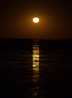
After the sun has passed beyond the horizon and the Milky Way is lighting-up the sky, a crowd can be found gathering along the coast with cameras in-hand eagerly waiting in anticipation of this 2-3 times a month event between March and October, which falls mostly, and conveniently, during the dry season.
Moonrise over Roebuck Bay – Broome
At precisely the advertised time a dim glimmer on the black horizon begins to glow and camera shutters start to clatter. Within minutes a deep orange crescent begins to appear, slowly expanding into a glowing ball and casting bright streaks across the wet tide exposed mud flats. This isn’t a sunrise, though it could easily be mistaken for one, this is likely the strangest moonrise you’ll witness, this is the Staircase to the Moon.
Due to the extreme tides, which are among the largest in the world, and a shallow bay, the tide reaches out for several kilometres leaving the extensive mud flats high and dry during the low tide. As the moon begins to rise it’s white reflected light from the sun passes side-on through the Earth’s shallow atmosphere filtering the blue hues and leaving just the yellows and reds that create our orange moonrise. And as the moon continues to rise higher into the sky the moonlight takes a shorter path through the atmosphere and less colour is filtered rendering the moon its more familiar blue/white hue.
Almost there…
Photographing the moon is rarely easy. For one it is much smaller than it appears in your viewfinder but it is also extremely bright against the blackness of space, bright enough that it can be clearly seen during daylight hours. Secondly the dark sky misleads camera meters resulting in overexposure of the moon and only a very limited, and very expensive, number of cameras are able to record such extreme contrast.
Staircase to the Moon
Unfortunately on our visit it was sufficiently windy that, even with a sturdy tripod, the long lens moved enough to blur many of my attempts to photograph this phenomenon. Hopefully we may get a second chance later on our trip as we head further west.
Pronounced ‘Der-bee’ not ‘Dar-bee’ as in the originating English town name, Derby is a small town on the Kimberley coast between Darwin and Broome. Sitting at the edge of an enormous estuary, Derby has the second highest tides in the world reaching as much as 11.8-metres during King tides. And that, unfortunately, is all it really has going for it apart from the sunsets over the Indian Ocean.
Loch Street is lined with Boab trees where the Tourist Information Centre is located. Very helpful staff unless you arrive 15-minutes from closing time when you can expect to be made to feel somewhat unwelcome.
Running parallel on Clarendon Street is Jila cafe where you can enjoy fresh cakes and pastries as well as Italian style meals in the evening as we did. There’s also an interesting collection of books to read while sipping an iced coffee and several Italian motorbikes on display for those with a two-wheel bent.
Sitting on the estuary means mud flats and here in Derby they are enormous, literally as far as you can see to the east, west and north. Our caravan site backed onto the western edge of the flats with very little to see but at least we were mostly sheltered from the wind with some well established trees.
Derby Jetty at sunset
A loading terminal at the jetty just north of Derby town centre can be reached along Jetty Road and is a popular spot to watch the sun set or fish for dinner, as long as the crocodiles don’t beat you to the catch.
Also by the jetty is the Derby Wharf Restaurant serving table meals as well as take-aways such as the local fish & chips. However, we made the mistake of eating here one evening and were served, after a very long wait, with over-cooked fish and chicken dishes. And add to that the elderly ‘entertainer’ who can neither sing or play his guitar too well through his distorted sound system. Normally an evening musician would get a clap or some form of applause after each tune but here you could hear a seagull fart several hundred metres away.
Things to do
Tourist points of interest are the Old Gaol and a little further away the Prison Tree where, supposedly, those not conforming to the rules of the time were held captive in the hollow of the Boab tree trunk. And secondly, not forgetting the longest cattle trough ‘south of the equator’ all 120-metres of it. Those with a pastoral background may find this a little more captivating than us.
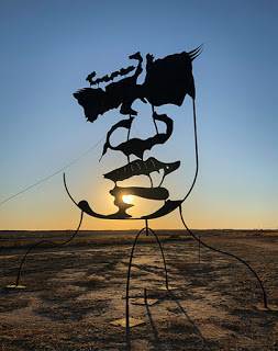
Aboriginal Man
One saving grace is the clever art form close to the Kimberley Entrance caravan park. It’s not immediate what it is or what it represents but wait until closer to sunset when people armed with cameras arrive and you’ll soon discover the hidden image. Impressive what can be created with a few discrete pieces of steel.
Pretty much everything else was either closed, closing or closed down. The local swimming pool displayed its open swimming times but the gates were firmly locked and the IGA supermarket gave the impression of a store ransacked in a riot with largely empty shelves.
Derby, it’s a town not just asleep during the busy tourist season, it’s in a coma.
A very early start today to meet with our tour at 6.15am but at least we get to see a WA sunrise as compensation. We had been warned that we were in for a rough ride along the rutted gravel road to our destination and it was, very rough. But getting to see special places like today’s in Australia is rarely easy, or comfortable, but worth it.
Purnululu – North
Today we are heading out to Purnululu National Park, a World Heritage Site, previously, and more popularly, known as the Bungle Bungles. Little known or explored by Europeans until an ABC TV programme filmed in the area in 1983, when public and scientific curiosity was aroused. What had created these spectacular black and orange stripped, beehive-shaped rock domes?
The Bungle Bungle Range has been on our must visit list for many years and today, finally, we were not only going to see them but also walk among them. And more…
Rough Ride
Our 4WD bus didn’t look in the best shape, but then what would after 450,000KM on dirt roads. It still had life in it and apparently coping better with the Bungles than the new bus that was shedding nuts, bolts and passenger seats. But an hour of bone-jarring ruts, bumps and floodways, past ghost gums, mounds of spinifex, dry creeks, feeding wallabies and moonscapes, got us to the Purnululu Visitor Centre. We still had 30-minutes of rough road ahead of us to reach our destination but everyone was ready for a break and a chance to stretch and put joints and false teeth back in place.
The Domes
There are some enormous escarpments along the route, moonscape-like hills and green valleys full of ghost gums, not what we had expected to see from all the published photographs, but these were just a teaser to what we finally started sighting – the characteristic stripped domes of the Bungle Bungles. And it wasn’t long before we were enjoying our morning tea break stood right in front of these amazing, other worldly domes.
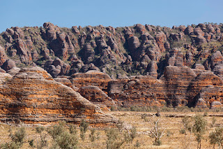
Purnululu National Park – The Bungle Bungles
What, on first appearance looks to be different layers of rock, the domes are actually comprised entirely of almost white sandstone. The orange bands are layers where water from the wet season has seeped to the surface taking iron along with it and rusting where it is exposed to oxygen. This is the same process that causes the classic red earth and rock of much of the north and west of Australia. The black bands are also the result of water seepage but have a higher moisture content allowing Cyanobacteria to grow on the surface. These are the same single cell life forms that were known to exist 3.5-billion years ago, one of the earliest known forms of life on this planet.
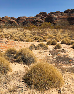
Spinifex and Beehive Domes
You have to ask where this sandstone came from in the first place, after all sandstone was once just loose sand formed by the sea, glaciers or rivers. A clue is visible in narrow bands of the rock walls. In this case pebbles of an ancient river are embedded in the sandstone showing this area has had fast flowing water for millions of years. But in turn those pebbles were at one time themselves, chunks of rock that tumbled from ancient cliffs into flowing water. Research suggests the rock that forms the Bungles is between 350 and 400-million years old and their current form has been created over the past 20-million years.
Our first walk took us around many of the sandstone domes along a dry creek for a close-up view where our guide, Steve, explained the process that created them and the related human history. They look delicate, and in places they are but the Cyanobacteria is helping bond the sandstone surface slowing its erosion. Needless to say we were all looking through our viewfinders for the best place to take a photograph as we continued our walk.
Domes Walk – Riverbed
The Aborigines have known of these features for tens of thousands of years and many areas are held sacred by them but the first Europeans that passed through on cattle droves thought them nothing remarkable. By contrast, in 2003, Purnululu was added to the UNESCO World Heritage List joining such elite company as the Grand Canyon, Yellowstone and Yosemite National Parks in America, the Dolomites and Mount Etna of Italy and, of course, Australia’s eleven other listed sites including the Great Barrier Reef.
Cathedral Gorge
Part way along our walk the path divides leading to Cathedral Gorge, a place of outstanding proportions. Walking beside a deep but dry riverbed cut by rushing water, we followed a narrowing gorge with orange sandstone walls rising over 200-metres above us and climbing several sets of steel steps before the enormous scale of Cathedral Gorge was revealed.
Cathedral Gorge
It is hard to convey the scale of this place from a photograph – you really need to be standing here yourself to appreciate just how big this water cut gorge is.
You will certainly have seen it on TV or any Qantas flight where the heart tugging ‘I still call Australia home’ song is played from the gorge along with the entire Sydney Symphony Orchestra.
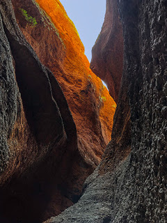
Echidna Chasm
The day was still young and following lunch we were off again, this time to the north and another hour on the gravel road. Our next destination is Echidna Chasm and what a remarkable place it is and absolutely worth the discomfort.
The path is a little tough on the ankles as it clambers over large river rocks and boulders beneath towering cliffs lined with Livistona trees. However, these cliffs were entirely different from the domes we had left behind. The entire area is comprised of conglomerate, a mixture of different size pebbles and boulders solidified in place by sandstone. Where exposed to oxygen it looks much like orange-coloured concrete and is almost as hard.
Cathedral Gorge entrance
The chasm quickly narrows and darkens with slits of light from above giving the upper reaches a warm glow. Several large chunks of rock have fallen but remain precariously wedged between the chasm walls and further in, just as it looks as though the way is blocked by huge rock falls, you can weave your way around them, up steps and finally arrive in a round amphitheater with unusually high humidity.
The return walk is just as impressive as you work your way closer to daylight and the dry heat of the sun. We hadn’t heard of this chasm before but so glad we got to see it.
Lookout!!
As we headed back towards camp on another long, rough drive, Steve had a treat for us. We stopped at Steve’s favourite viewpoint and what a impressive place it was with a 360-degree view across a valley with spear and spinifex grasses, ghost gums and orange cliffs glowing in the setting sun. The steep but short walk to the top was worth every step.
Kungkalanayi – Lookout
Dinner One last treat was waiting for us as we got back to camp. Included with the full-day tour was dinner, which tonight was three large pieces of eye fillet, cauliflower and broccoli bake, sautéed potatoes and two salads with apple pie and ice cream to follow along with the great company of our fellow tour group.
Of all the tours we have done on our trip so far, this one is right up there with the best. You do need to be quite fit, wear suitable enclosed walking shoes and can handle the rough drive and uneven paths, but it is worth every ache you’ll have the following day.