The Never Ending Jetty

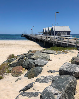
We have seen and walked along some impressive piers and jettys in various countries over the years but perhaps none more so than Busselton Jetty in Western Australia. At 1.84KM it is the longest timber-pile jetty anywhere south of the equator.

Busselton Jetty

The initial jetty, just 176-metres long, was completed in 1865 and provided a much needed facility for ships to dock at a time when agriculture, tourism and the timber industry was booming. At that time there were no personal income taxes instead the government sourced revenue on imports and exports with the jetty no doubt soon paying for itself.

In 1872 at a cost of £88 the jetty had its first extension to enable larger ships that were finding Geographe Bay to shallow to dock. However, just three years later the extension proved insufficient and with silt building up in the bay another 144-metres were added, this time costing a more considerable £626. Silt continued to build and in 1884 another 229-metres were added. Then another 353-metres three years later and another forty in 1890. And we’re not done yet…

More, bigger

The increasing size of ships required deeper access and so more extensions were added: 130-metres in 1894, 150-metres in the following year and 261.6-metres the year after that. By 1907 the jetty had reached just short of 1.4KM. But, as you will have gathered by now, there was a trend developing and they still had not yet finished.

One BIG Jetty

A rail line was added easing the transport of goods and replacing the existing horse and cart but it also introduced a new problem – fire. Embers from the steam powered engine often took hold on the timber deck requiring someone to follow behind the train stamping them out.

Then in 1911 an additional 603-metres was added. This, and two-months of dredging, allowed even larger ships to dock safely bringing in tourists to visit Western Australia’s first major tourist attraction – Ngilgi Caves, more of which to follow. Sea baths were also created to allow visitors to swim safely away from the ‘Sea Monsters’ and a pavilion for band concerts. Busselton was booming.

One LONG walk

Finally one last addition of 16-metres in 1960 brought the jetty up to its current dimensions and the longest of its type in the Southern Hemisphere. But it was all too late to continue efficient operations as the larger port at Bunbury began to take business from the jetty and in 1972 it was closed to trade as a shipping port. Five thousand ships had used the jetty over its 100-years service and significantly helped the development of the South Western corner of Western Australia.

End of the line

Although the jetty’s port operation days were over it wasn’t the end of its working life. Though the state government had it in mind to be dismantled, the local community and Shire campaigned to take control of the jetty and develop it as a tourist attraction even proposing adding an underwater observatory. Nature, though, had other plans and on April the 4th 1978 cyclone Alby swept away 700-metres of the oldest section of the jetty. And there the jetty remained, isolated from the shore and gradually succumbing to the effects of the weather and sea.

However, this was a jetty that had no intention of coming to an end and a survey of the community by the Shire received a 90% response in favour of preserving the jetty and resulting in a $500,000 kickstart fund being allocated as well as the formation of the Busselton Jetty Preservation Committee. Funds raised and the injection of the promised money from the Shire allowed the first part of the major restoration to start at a cost of $660,000.

Old Jetty timbers

In 1995 a small train was re-introduced using the original rails and charging a fee to take people to the end of the jetty and back. It additionally allowed the mobility impaired to enjoy the views and fresh air along with the fishing, swimming and sporting events already popular. Diving also became popular and the jetty has become one of Australia’s top ten dive sites.

Fire!!

In 1999 a huge fire took hold and destroyed a 70-metre section of the jetty. Only cutting through sections of the timber deck with chainsaws halted the flames. The fire was believed to have been started by a carelessly discarded cigarette. In order to help raise funds sufficient for significant incidents like this an underwater observatory was created and put in place at the end of the jetty. In the first 6-months from December 2003, 60,000 people took the opportunity to view some of the 300 marine species that call Geographe Bay home.

In 2009, the Western Australia State Government donated $24-million for the complete restoration of the jetty to return it to an ‘as new’ condition, which included replacing the remaining fire prone timber deck with cast concrete panels. And on the 6th of February 2011 with thousands of people attending, Busselton Jetty was re-opened.

Jetty Shop and Museum

But wait, there’s more

Not content, plans are now underway to add a giant glasshouse on the last section of the jetty with a cafe and sunset bar. It will be lit at night providing a warm glow and highlighting the enormous length of this much loved piece of historic architecture.

And finally…

Interestingly, and perhaps to encourage youngsters to make the full walk to the end of the jetty, a number of plaques along the way pose a series of questions about the jetty with each subsequent plaque holding the answer and presenting the next question. We have seen similar with roadside signs on some remote highways to help alleviate the boredom of long journeys. Quite educational too.

Foreshore Playground

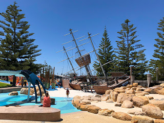
We thoroughly enjoyed our walk along the jetty and wandering around the excellent work that has taken place on the foreshore with new parking facilities, landscaping, eateries and the best children’s adventure playground we’ve seen anywhere with a huge listing ship, a giant squid and a whale swimming through the wake of the ship.

Busselton in a fast growing town and absolutely worth a visit on your West Coast trip. So much so we extended our stay.

Thrombolites of Lake Clifton

Twenty minutes south of our current camp at Mandurah (WA) and sitting in a salty lake within Yalgorup National Park are some of the oldest continuous living creatures on earth.

Up to 120-metres in width and extending for 15KM along the shoreline, the Thrombolites of Lake Clifton are believed to be at least 2,000-years old and the largest known formation south of the equator. Resembling large boulders sitting in shallow water it would be easy to dismiss them as just an unusual group of rocks, however, these rocks are alive.

Thrombolites – Living Fossils

Growing at less than 1mm each year the Thrombolites are built by microbes, which extract energy from the sun through photosynthesis and in the process create oxygen and calcium carbonate – more commonly known as limestone, which is responsible for the visible mounds we see today.

Thrombolites or Stromatolites

If you have been following our adventures you may remember the similar living rock formations we saw at Hamelin Pool near Shark Bay. Though they look the same and form in similar conditions, Thrombolites are built from small, rounded clusters that grow into a common mound structure whereas Stromatolites develop in circular but flat layers. Both, however, are known from fossil records to be the earliest forms of life on the planet around 350-million years ago. And both are believed to have been the majority source of oxygen that allowed more complex life to develop.

Thrombolites and Stromatolites continue to produce oxygen and as such are highly protected and listed as critically endangered species.

Buzzzzzzzz

We visited Lake Clifton in early November and had the unpleasant experience of walking through clouds of buzzing and biting mosquitoes. The best time to visit is during the summer months when the water level has dropped a little partially exposing the Thrombolites above the surface of the lake. A jetty provides a good viewing platform and helps protect the Thrombolites from careless feet.

Thrombolites at Lake Clifton

Lake Clifton and the Thrombolites can be reached via the Old Coast Road and then following either Mount John Road or Clifton Downs Road. A small car park and information board is just 50-metres from the boardwalk.

Just remember to take plenty of insect repellent!

The Quokkas of Rottnest

Today was another of our early start days to get to the ferry terminal at Hillarys by 7am. Our destination this time was Rottnest Island named by early Dutch explorers who believed the local marsupials were large rats and so gave the island the Dutch name of Rott Nest – literally Rats Nest.

We had booked ahead and included bicycle hire as the only other visitor transport options on the island are by foot or a Hop-on, Hop-off bus. It was a bold choice as I hadn’t cycled for over 26-years and a long time too for Catherine. Still, if you want to get around the island it is the best way and the glorious weather was on our side with little wind and a clear, deep blue sky.

The 45-minute crossing was surprisingly choppy in a few places with an ocean swell but we were soon into calm waters again and mooring at the Rottnest Jetty. All the bikes had been loaded onto the deck and as a result were exposed to the waves giving them a good soaking.

We set-off, a little wobbly at first but it seems it’s a skill you never forget, just in need of a little practice. We didn’t get far before we were greeted by our first ‘Dutch Rat’ more correctly known as a Quokka though far less easy to spell.

Rottnest Quokka and Joey

The Quokka, pronounced ‘kwoka’, is a marsupial about the size of a large rabbit with a thick, heavy tail, the same gait as a kangaroo and the most adorable face. They’re friendly too and will happily pose for a photo for a modest fee. It is a current trend to take a selfie with a Quokka though they’re probably tired of having cameras and iPhones stuck in front of their faces when all they really want is some food. Being wild animals, of course, signs are everywhere telling people ‘Do not feed or give water to the wildlife’, ‘Do not touch the wildlife’ but still they do and the poor things become reliant on humans.

I can smell Coffee

But it was time for a coffee, of course, and visitors to the island are well catered for with a few restaurants, a supermarket and our choice – the Rottnest Bakery. They must have known we were coming and had clearly been busy baking for us since the early hours. There were many tempting cakes and pastries and I had my eye on a custard doughnut until Catherine pointed out the enormous cinnamon scrolls big enough for the both of us and the size of a large plate.

Which Way?

Now with an island just 11KM long and 4.5KM at its widest you would think navigating what few roads there are would be simple, especially with the supplied map. However, the road signage appears to have been created by someone with a sense of humour and an interest in bird life of the avian variety. The map clearly shows the three cycle routes in brown and green with a splash of red. But trying to find where any of them start from the jetty or cafe area is complete guess work. Worse still, if you do chance to find yourself on one of the routes then you’ll quickly realise they are signed with images of birds and not the colours of the routes on the map. Still, we were up for the challenge even though our muscles clearly were not.

Parakeet Bay

We took the counterclockwise route and quickly discovered Rottnest Island was nowhere near as flat as it appeared from the sea. We also discovered which leg muscles hadn’t been exercised for a while – going uphill was punishing but we were determined not to get off and walk when we had only just started. The effort was soon rewarded, though, as we topped the hill and got our first view of Parakeet Bay with its clear turquoise water.

Ospreys

More hills, many more beautiful bays and white sandy beaches followed. Rottnest Island is gifted with such stunning scenery and no more so than at the furthest point from the jetty at Cape Vlamingh. Here mighty waves smash into the rocks along the coast pushed by prevailing winds, while just around the corner Fish Hook Bay provides shelter, deep aqua-blue water and provides a habitat for Ospreys. One Osprey nest is clearly visible on a prominent rock in the bay and is believed to be 70-years old.

Fish Hook Bay

Saddle Sore

After a brief break from the saddles and a spot of lunch, we retraced our route for a short while before turning towards the southern coast with good views of Wadjemup Lighthouse. A steep track leads up to the lighthouse and, apparently, gives good views across the island but we were happy to let those with less shaky legs enjoy the viewpoint. Instead we took a wrong turn while being distracted by a couple of cute Quokkas by the roadside and inadvertently headed north. To turn back meant a steep hill so we continued on briefly before turning south along a track that followed beside a somewhat smelly lake, past the end of the airport runway and on to a sandy path, which meant dismounting for a while and walking until we rejoined our planned route.

Windswept!

When the wind blows

Rottnest Island is exposed to the full force of the gales that blow across the Indian Ocean before reaching the mainland and its effect is clearly visible across the island with short trees and creeping dunes and none more so than one particular tree that we came across that has given up trying to resist the winds and just grows sideways.

The West coast of Western Australia is particularly windy during Spring and we were lucky to have arrived on the island on one of the few days when the wind was taking a break, though it would have been helpful pushing us up some of the steeper hills.

Porpoise Bay was another one of those stunning places providing views back towards Perth and its tall city buildings. With the road flattening out we were soon on our way back towards the jetty before a roadside sign stopped us in our tracks. It was posted where old railway lines cross the road to an old army depot at Army Jetty. It appears to illustrate what happens if you cycle across the rail lines at the wrong angle. From out of nowhere you sprout a red cape and turn into Superman. Cool! How many children seeing the sign would be tempted to give that a try?

Superman?

Finally back at the jetty we were in need of a bite to eat and a cooling beer and it appeared the Quokkas were looking for food too as they hunted for crumbs around the cafe’s tables.

All Aboard

Back onboard the ferry with bikes safely tied down and we were soon arriving at our starting port of Hillarys after a day of exercise, beautiful weather and lots of beautiful scenery.

Tomorrow was looking like we were going to be aching badly but it will have been well worth it and we would do it all again given the chance.

A day visit to Rottnest is absolutely recommended as long as you feel fit enough to cope with the hills. If not, take the Hop-on, Hop-off bus and enjoy all that the island has to offer.

Chilling in Freo

Popularly known simply as ‘Freo’, the beachside city of Fremantle, situated 20KM southwest of Perth city centre, is a delightful coastal town full of character, charm and more than a little history.

The town is named after English Naval Captain Charles Howe Fremantle who claimed the West Coast of ‘New Holland’ for King George IV and established the first camp in 1829 following suspicions that the French may have been showing interest in the west of Australia. After discovery of considerable reserves of gold in Southern Cross, Coolgardie and Kalgoorlie, Freo became equally a prosperous port and town resulting in some of the impressive architecture that remains to this day.

Fremantle Harbour

We have been in Perth for the past week enjoying much that the city and its outlying regions has to offer. I have visited Perth several times previously but it is the first for Catherine and the first for both of us exploring Fremantle. And having a street known as the Cappuccino Strip we knew we were in the right place for a good coffee.

Fremantle Markets

A popular spot for art and crafts, food and entertainment, Fremantle Market should be on your list of places to visit. Fresh fruit and vegetable stalls sit at one end of the market with a huge variety on offer. Still run by the families of many of the Chinese Market gardeners that settled in Perth around the time of the gold rush in the late 1800’s, it is good to see the trade surviving the endless onslaught of the major supermarkets.

Being a little hungry we sighted Michel’s Crepe Suzette tucked into a narrow spot near the market entrance. And what a choice of fillings there were with menu boards plastered on all available wall space. Highly recommended, though a little slow on service, definitely worth the wait.

Stripey

Fremantle is home to artist Wendy Binks who’s work we had seen in many places while travelling down the west coast of Western Australia. One of her popular animal characters is the Emu, cutely named ‘Stripey’ for the patterned feathers of the Emu chicks. In need of a new coffee mug, Stripey will now be joining us for coffee each day.

Stripey the Emu Chick

Little Creatures

These days every good town has its own brewery – a celebration of the region’s crops, water and talent and Freo is no exception playing host to the famous Little Creatures Brewery.

Clearly very popular judging by the number of people visiting today, at least those not spooked by all the Hallowe’en decorations though there were certainly more than a few spirits in the air.

Maritime Museum

America’s Cup victory for Australia came on the 26th of September 1983 with yacht Australia II after an epic battle with America’s Liberty. It was the first time in 132-years that America had lost to another country and back in Australia the close race had the nation on their knees even though it took place in the early hours. During the after race celebrations Australian Prime Minister Bob Hawke famously said, “Any boss who sacks anyone for not turning up today is a bum!”

America’s Cup

The win was attributed to a new keel design that sported a wing that remained hidden until the yacht was hoisted from the water following the triumphant win. And it was a feature that the losing American team launched an objection to but it was quickly overruled by the officials. Australia II and its controversial winged keel is now proudly displayed at the Fremantle Maritime Museum.

Never without a little controversy there is a background to the cup on display in the Maritime Museum. The cup was just a stock item created by Garrard of London, jewellers to the Royal Family. It was bought and then donated to the Royal Yacht Squadron in 1848. Then in 1851 the Royal Yacht Squadron presented the trophy to the winner of a race around the Isle of White, which was won by the schooner – America.

Following the win the cup was taken to the New York Yacht Club on Rhode Island and renamed the America’s Cup. There it remained until 1983 when Australia II beat Liberty. Or rather there it still remained – America never gave up the real cup. Instead Alan Bond, who bank-rolled Australia II, commissioned Garrard to produce a replica cup. Another replica was created in 2000 at the request of famed sailor Rolly Tasker for his Sailing Museum. This time, however, it was created by a New Zealand jeweller after Garrard refused to produce any more. This is the copy now on display at the Maritime Museum.

Historic Fremantle architecture

Historic Architecture

Fremantle Council have done a fantastic job in preserving the heritage of Fremantle. Any rebuilds or refurbishment of historic buildings must retain the original street frontage. The result is some of the best preserved, freshly painted and graffiti free buildings in Australia… with one very notable and very obvious exception – the Police Station on High Street, which it shares with the quite appropriately named NAB Bank.

There is plenty to see and do in Freo but make sure to finish with a coffee and cake along the Cappuccino Strip and watch the world pass by… and all the posers in their Ferraris, custom cars and Harley Davidsons.

The Pinnacles

Located 16KM south of the coastal town of Cervantes in Western Australia is a remarkable and immense outcrop of stone pillars known as The Pinnacles. Just as remarkable, though, no one is quite sure how they formed.

The Pinnacles

Set within Nambung National Park, the Pinnacles Desert looks like a scene from an other-worldly Science Fiction film. Thousands of limestone pillars upto 5-metres tall stand among compacted yellow sand. Unusually for a National Park intent on preserving its heritage, this is one location you can both drive around and walk freely. There are even regular parking bays, which is a first on our trip.

Pinnacles Drive

More suited to a high-clearance 4WD vehicle than a standard car, the Pinnacles Drive leads in a winding loop around the limestone pillars, which extend over a large area of ancient sand dunes. The track is clearly marked by regularly spaced boulders and occasionally pinnacles, which provide little clearance for wider vehicles or less capable drivers as tyre marks and paint scrapes attest.

Right at home among the sand and Pinnacles

Windswept Origins

The strong winds on the West coast had initially eased a little on our visit but it was clear to see areas where the wind sweeps through the park gradually eroding the pillars into some unusual shapes. The wind is also slowly exposing further pinnacles in a cycle that has repeated many times as sand blows inland from the nearby beach. In fact the formation of the Pinnacles is closely tied to the winds common to the Western Australia coast.

Planet Earth?

During a period of abundant marine life, shells rich in lime deposited on the beach gradually broke down into fine-grained sand and subsequently blown inland forming dunes. At this point three possible theories are trying to explain how the pinnacles formed. The most probable at the moment, at least until further studies prove otherwise, suggests rain falling on the dunes leached calcium through the upper layers of sand creating a soft limestone below that, through time and with successive deposits of sand, compacted and hardened.

Subsequent periods of environmental change created soils that covered the dunes allowing plant life to flourish. The plant’s roots burrowed down into the limestone seeking moisture and creating cracks in the process. During much drier periods the wind stripped the topsoil and loose sand exposing the limestone below to the weathering effects of the seasonal winds and further eroding the cracks creating isolated pillars. The whole process taking somewhere around 80,000-years to create what we see today. Though come back a few years later and it may well have changed again with new pillars exposed and some buried under the shifting sands.

Ancient City?

Well at least that is the scientific take on the origin of the Pinnacles. Early mariners viewing from the sea believed the pinnacles were the ruins of some ancient civilisation but it wasn’t until the 1950’s that the area was truly explored. Realising the geological importance of the region the Pinnacles Desert was placed under protection with the creation of the Nambung National Park.

The Pinnacles is yet another of those photographer’s paradise locations in Western Australia and a must see on a west coast trip. The close-by beachside town of Cervantes provides camping facilities as well as motel rooms, a supermarket, newsagent, fuel and the famous Lobster Shack providing delicious seafood meals.