Stick Shed – a curious and intriguing name for a building but this is in no way any ordinary building – it’s immense. Even more remarkable, it’s the smallest of two giant sheds built in the Wheatbelt township of Murtoa* in Victoria.
Murtoa Stick Shed – view on entry
The Murtoa Grain Store, by its official name, was built in 1941 in just 4-months, a remarkable achievement when you realise the enormous scale of the building. It was constructed to store wheat following a bumper year’s harvest when overseas exports were being severely restricted during Word War II. But, surprisingly at first, there was opposition from the businesses that supplied grain sacks. The reason being they were set to lose out and in a very, very big way.
Hand Built
Measuring 270-metres long by 60-metres wide, the floor of Stick Shed covers an area of 1.6-hectares (4-acres) and every square metre of it was laid in hand-mixed concrete. The enormous corrugated steel roof is supported by 560 unmilled poles, referred to as ‘sticks’, reaching upwards as high as 19-metres along the central ridge line and braced by twisted steel cables.
Calculating the angle the designers needed for the roof, while making best economical use of materials, relied on what is known as ‘the natural angle of repose’. In this case, when piled, wheat creates a natural pyramid shape with a consistent slope angle of 23-degrees and, naturally, that is exactly the angle the designers used for the Stick Shed roof.
Murtoa Stick Shed
Sour Grapes
As mentioned, the grain sack suppliers objected to the construction of a loose grain store arguing, with some credible reasoning that the grain would be exposed to vermin, moisture and potentially rot. However, loss of sales was the real reason and understandably. The Stick Shed was designed to hold the equivalent of 1-million 80KG sacks (3-bushels/sack) – clearly a considerable financial setback for them. The advantage, though, of loose storage meant no manual handling of grain sacks and a considerable saving in labour costs.
Big and Bigger
On completion of construction the first load of grain was delivered on the 22nd of January 1942 and by June it was filled with 3,381,600 bushels (approx 90,000 tonnes) of wheat. A second larger shed was constructed beside the Stick Shed capable of holding an additional 7,500,000 bushels and nearby a further 10,000,000 bushel shed was built. Today, however, just the Stick Shed remains, now preserved for the future and on the National Heritage List.
A Must See
The Stick Shed is one of those buildings that you cannot really anticipate the scale of. It is way, way bigger than you may imagine and guaranteed a ‘Wow!’ as soon as your eyes adjust to the light level.
We’d absolutely recommend a visit for all the family. There is an excellent introductory session by knowledgeable guides before you are free to wander and ample parking available.
The Stick Shed was featured as the location for Australia’s CH10 Master Chef programme on July 6th 2023.
N.B. If you are a keen photographer beware it is quite dark inside and a tripod is very much recommended. However, even on a dull day, smartphone cameras can give excellent results.
* Murtoa is the indigenous name meaning ‘home of the lizard’.
Our 3-month adventure in Tasmania has come to an end and we’ll soon be boarding the Spirit of Tasmania ferry back to the ‘mainland’ and the long drive home with a little detour through the Gold Fields of Victoria.
Brrrrr!
We can probably sum up our time here as becoming increasingly cold as Winter sets in. Very windy too with gales at times strong enough to shake the caravan and loosen fillings. But we’ve also had plenty of sunshine to enjoy the golden leaves of the deciduous trees throughout Autumn. There has been snow and rain too, lots of it, but mostly overnight and it hasn’t stopped us getting out and about and exploring what Tasmania has to offer the independent traveler.
Flora, Fauna and Roadkill
We’ve seen far less wildlife than on our previous visit. Plenty of bird life, sea life, sheep and cattle, the odd snake but also many, many wallabies, pademelons and possums apparently fast asleep on the roads and verges being watched over by hungry crows.
The Tarkine – Land of the Giants
And trees, lots of those too, especially the giants in the Tarkine, Mount Field National Park and Styx Tall Trees Conservation Area. But also not forgetting the beautiful Fagus trees at Cradle Mountain and the Leatherwood and Myrtle trees and mosses and algae everywhere we went. Of course no forest would be complete without fungi and in Tasmania there’s no exception with more variety and colours than I’ve seen anywhere before.
Hygrocybe pseudograminicolor
We did get to see our first wild Platypus and Fairy Penguins – the world’s smallest, which waddle onto land overnight to shelter and feed their young. We saw Pink Robins and Fairy Wrens flitting among hedgerows, Black Swans gliding across the lakes and coastal shores and Egrets and Herons wading in the shallows. Even the Lonely Albatross put in an appearance during a feeding frenzy off the coast of the Tasman Peninsula along with giant Tuna rocketing out of the water chasing after bait fish.
Less popular though were the mosquitoes, seemingly fitted with silencers, putting in a late season appearance when you least expect them. Oh, and heat-seeking leeches ready to climb up your trouser leg if you stand still too long.
History
We’ve experienced the history telling of past explorers; Cook, Bass, Bligh, D’Entrecasteaux, Flinders, Furneaux and Tasman, of the indigenous people of Lutruwita (Tasmania) and the appalling way Truganini was treated. We discovered more about the Australian Convict era and the often petty crimes that brought the unwanted from the UK to Tasmania’s shores. And never to forget the modern day massacre at Port Arthur.
Port Arthur
Scenery
For a relatively small island state Tasmania has an enormous variety of scenery. From rolling grassy hills, mossy forests, mountains, lakes, waterfalls, towering sea cliffs, the orange coloured boulders along the Bay of Islands, white sandy beaches, turquoise water and true wilderness – there’s something here for everyone.
Dove Lake – Cradle Mountain National Park
We’re sad to be leaving Tasmania, our home for the past three months, but the warmer weather of Queensland is now calling us home. But, of course, there are more adventures to come. We still have so many more places to explore around Australia and further afield. Our 10-month ‘Big Lap’ around Australia in 2019/20 was just the start and we only skirted around the country – there’s a whole world to discover inland and off the beaten track.
For now we’ll be heading north and exploring the gold fields of Victoria and following the Australian Silo Trail.
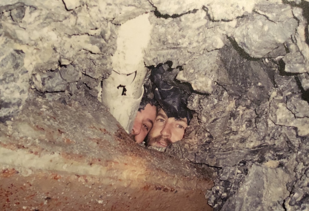
Beaconsfield Gold Mine, 40km north-west of Launceston in Tasmania, became the site of a global media frenzy when, at 9.26am on 25th of April 2006, a small earthquake triggered a rockfall 925-metres below the surface where 17 miners were working. It was a story of endurance, incredible bravery and tragedy.
Early Escape… for some
Of the 17-miners working underground on that day, fourteen managed to reach a safety chamber and ultimately made it to the surface without injury. However, for Brant Webb, Todd Russell and Larry Knight it was another story.
Larry was operating a Telehandler while Brant and Todd were in a 1.5 cubic metre steel cage on the front of the Telehandler’s extendible arm fixing a steel mesh to a barricade when the rockfall was triggered. The three men were trapped underground and their condition unknown leaving their families and work colleagues fearing the worst.
Unknown to the world above, both Brant and Todd had survived the collapse but were partly buried with rubble that had fallen through the mesh of their cage. They managed to free themselves within the cage by cutting through their clothing and boots that were wedged between rocks.
Trapped Miners Brant Webb and Todd Russell
While rescue teams were working to discover if the mine was safe to enter, the two trapped men were able to collect water in their safety helmets that was seeping through the fallen rock. Other than water and a single muesli bar they had nothing to sustain them until rescuers could reach them.
The search for Survivors
After confirming the mine was now safe to renter, rescuers began the search for the missing men. They managed to reach within 15-metres of where they believed the men would have been prior to the rockfall but a large and potentially unstable debris pile blocked their way.
By the 26th of April a remotely-controlled earth mover had been brought in to begin removing the debris and early the following morning the body of telehandler driver, Larry Knight, was discovered having been pushed clear of the rear of the machine by the fall.
Progress came to a halt when further inspection showed it was unsafe to continue.
Action Plans
Rescuers, colleagues, mining experts, surveyors, medical staff and mine management worked through countless options to form a rescue plan to try and extract Brant and Todd from the mine whether they were alive or not.
Surveyors identified a potential route from the main access tunnel to a point just in front of the telehandler where they hoped they would find the remaining two miners. The rescue effort resumed on the 29th of April by blasting a new tunnel using at least six powerful explosive charges. Unknown to the rescuers the blasts were dislodging rocks, which were falling into the cage at times faster than Brant and Todd could clear them. With each blast Brant wrote the time and date on his overalls in the event they didn’t survive the explosions. Rescuers would at least know they had survived the initial rock fall but died as a result of one of the blasts during the rescue attempt.
Both men wrote letters on their clothing to their families in the event they didn’t survive and sang favourite songs to try and keep up moral.
They’re Alive!
At 5.45pm on April the 30th the Underground Manager, Pat Ball and Mine Foreman, Steve Saltmarsh descended to the level known as ‘925’ (925-metres below the surface) and, on approach to the rockfall, they yelled out in the hope they could be heard by the trapped miners. Both Brant and Todd immediately yelled back, “We’re in here!”. The pair were alive and news quickly reached the surface and the waiting families, friends, colleagues and media. Within minutes the news was heard on TV and radio around the world.
In the meantime one of the rescuers managed to find a way past the debris pile and got so close to the cage that he was able to reach through and shake hands with Brant. However, as an escape option, it would have required cutting the cage wires that were supporting the weight of the rock pile above the two men and the option was subsequently abandoned. Blasting was halted and instead a small, 90mm hole was chosen to reach the miners. Both Brant and Todd listened out for the drill to help guide it toward their location.
After successfully drilling through to the cage, a PVC pipe was fed through by which food and water could be passed to the men. A telephone was disassembled and passed through the pipe along with instructions on how to reassemble it. Later a torch, magazines, toothpaste and an iPod was fed to them via a modified plastic water bottle. A digital camera was also passed to the men so they could photograph their situation and the rock around them. Importantly this allowed the rescuers to ascertain the safest way to reach them without triggering further rockfalls.
A change of Plan
It wasn’t until The 1st of May that Brant and Todd were told about their colleague Larry Knight. On the same day the decision to continue blasting and drilling was stopped over fears of another collapse. Instead a machine known as a ‘raise borer’ was assembled, which it was hoped would be able to drill a horizontal tunnel one metre in diameter. It was designed to be used only vertically but it was thought to be the fastest option to get to the men and create a tunnel large enough for them to escape through. However, it would require bolting to a concrete base, which would take time to construct and allow the concrete to set.
In the evening of May the 3rd drilling of a pilot hole began, which ultimately took more than three days to bore through the remaining 12 metres of rock. Drilling was much slower than expected after hitting a form of quartz that was described as being five times harder than concrete. At 8pm the following day the drilling of the one metre wide escape tunnel began. It would follow the pilot hole to a point just below the trapped men.
Breakthrough! – Brant and Todd
By early morning of the 6th of May the raise borer was 5-metres short of its target and took a further 12-hours to complete the escape tunnel. After disassembling and removing the borer the plan was for miners to lay on their backs and use hand tools to dig upwards to reach Brant and Tod. But the following day the rescuers hit extremely hard rock once again and their powered jack hammers were making no progress. Explosives expert, Darren Flanagan, fretted over the use of low-impact charges to break through the rock fearing it could trigger another rockfall and cause the cage to collapse. But there were no other options available and to the relief of all it was successful. At 9.30pm on May the 8th the rescuers were able to pass a probe through to the base of the cage – they were just one metre away from freeing Brant and Todd.
Breakthrough!
At 4.27am on the morning of the 9th of May, fourteen nights since the initial rockfall, rescuers Glenn Burns, Donovan Lightfoot and Royce Gill finally reached Brant and Todd, “I can see your light!” they yelled as they broke through into the cage, “ I can see your light too!” the miners replied.
Brant was the first to be pulled from the cage followed minutes later by Todd. After being checked over by a doctor, both men ascended the shaft’s lift and at 5.58am they walked out unaided to the cheers of the waiting crowd and the arms of their relieved families.
Brant and Todd reach the surface
Both men were treated for their injuries at Launceston General Hospital and just six hours later both men were able to attend their lost colleague, Larry Knight’s delayed funeral.
Looking to the Future
Twelve months after the rescue the mine restarted production and continued operating until June 2012 by which time reduced gold prices and high operational costs made the mine unviable. However, plans are ongoing to reopen the mine with gold prices doubling since closure. This despite repeated theft and vandalism at the site with the most recent break-in causing an estimated $1.5M damage to the site’s infrastructure.
Beaconsfield Mine and Heritage Centre
In addition to the exhibition detailing the 2006 rescue, the Beaconsfield Mine and Heritage Centre contains over 10,000 items of machinery and household items from the days of steam through to the 1970’s. There’s something of interest for everyone and you’ll find yourself spending hours exploring the many displays and buildings.
Situated just a few hundred metres from the centre of Launceston, Tasmania’s second largest city, is an unlikely mix of a Victorian Pleasure Garden and wilderness. Rarely will you find such a dramatic location so close to a city.
Cataract Gorge is a 5km long, 65-million year old natural wonder. Comprised of four distinct features; South Esk River, Cliff Grounds, First Basin and Duck Reach, and each of them unique.
South Esk River – Cataract Gorge
In the beginning
A settler by the name of William Collins made note of his visit here while exploring the Esk River and Port in 1804. It is believed to be the earliest record of the area in which he noted, “Upon approaching the entrance I observed a large fall of water over rocks, nearly a quarter of a mile up a straight gully between perpendicular rocks about 150 ft high. The beauty of the scene is probably not surpassed in the world”. Obviously in the early 19th century he would not have seen that much of the world to which he could compare. However, it is certainly impressive in its scale.
Victorian Splendour
The gorge quickly became a popular destination for Victorian visitors to ‘partake in the air’. Access up the river was initially restricted to walkers over a steep zig zag track or by boat to a large rocky outcrop jutting into the river known as Picnic Rock. Access was greatly improved in the early 1900’s when a suspended pathway, known as the King’s Bridge – Cataract Walk, was built by volunteers linking King’s Bridge to First Basin. Anchored high on the cliff wall, it was constructed by volunteers over a period of eight years. The walk provided an easy and mostly level pathway for pedestrians to approach First Basin and Cliff Grounds, once a swamp but converted to a park with exotic plants, specimen trees, Peacocks and a bandstand and restaurant.
First Basin – Cataract Gorge
To Pay, or Not
The Launceston City and Suburbs Improvement Association, formed at the end of the 19th century, was instrumental in the construction of the suspended walkway and additionally the Toll Keeper’s Cottage and Toll Booth adjacent to King’s Bridge, both of which were built in 1891. Unusually the toll was entirely optional and many, not too surprisingly, chose the option not to pay. The toll was intended to raise money towards further development of the gorge so, again not too surprisingly, the Association made the toll compulsory later in the year.
Cataract Gorge Toll Keeper’s Cottage
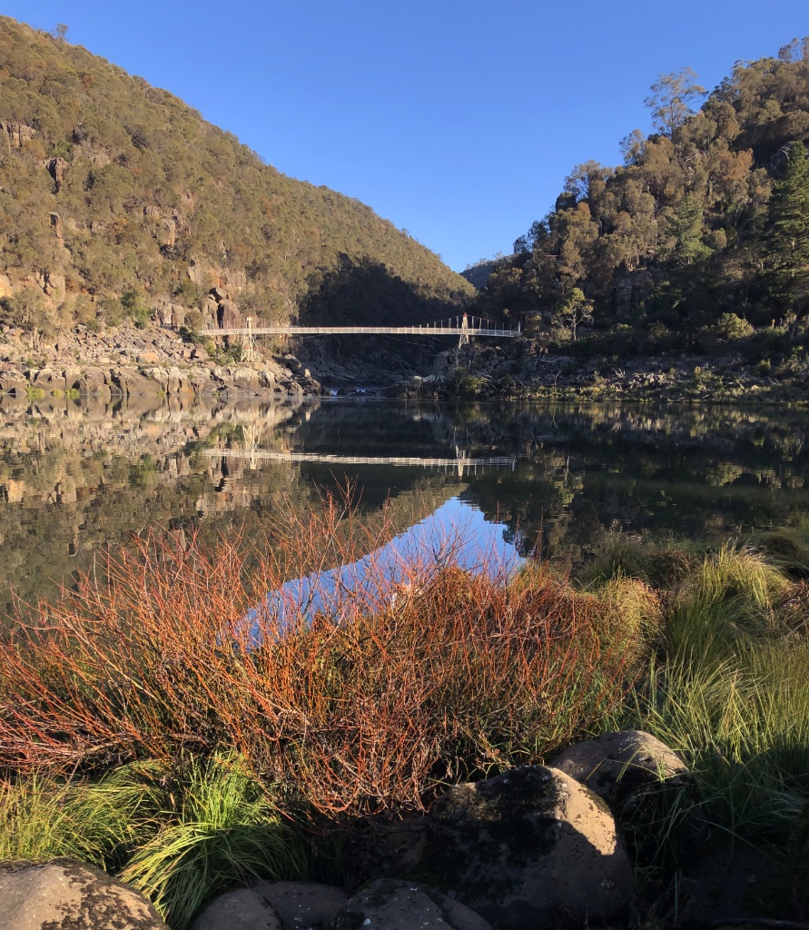
In 1904 the Alexandra Suspension bridge was formally opened. Situated to the south of First Basin, the bridge extended the King’s Bridge Cataract Walk and crossed the South Esk River giving safe pedestrian access to First Basin and a pathway leading further up the river for people to explore.
Alexandra Suspension Bridge – First Basin
First Basin
Most visitors today arrive directly at First Basin with its good parking facilities, a cafe, open grassy areas, a playground, the largest single span chairlift in the world and a large outdoor swimming pool. It’s more like a park with cliff side views – ideal for a weekend picnic with a young family. However, looks can be deceptive. Cataract Gorge is a place where raging torrents can and have swept away bridges and carry huge boulders downstream.
Upper South Esk River
Duck Reach Trail
The Duck Reach Trail from the Alexandra Suspension Bridge shows a marked contrast in scenery. No longer a place to sit and admire the green lawns and specimen trees and shrubs, here you are thrown right into a wilderness with native trees fighting for soil among the steep and fractured gorge walls and the boulder strewn river churning the water as it heads downstream towards First Basin.
The trail is a moderate walk with a steady incline and a number of steps as you approach the Duck Reach Suspension Bridge. On crossing the bridge there are two further tracks – the steep Reed Gully and Snake Gully. Both are for experienced and energetic hikers and form a 2km return track to First Basin. But we were here to see the now disused Duck Reach Hydro-Electric Power Station.
Power for the People
In 1893 Launceston City Council commissioned the construction of the Duck Reach Hydro-Electric Power Station. Frequent flooding in the gorge necessitated the station be built high above the South Esk River, which complicated construction and required the building of a heavy-lifting Flying Fox to transport materials across the river. However, just two years later on the 10th of December 1895, the turbines were generating electricity for Launceston and lighting the city with brilliant arc lights. It was Australia’s first commercial hydro-electric scheme and is believed to have been a world first providing water-generated electricity for a city south of the equator.
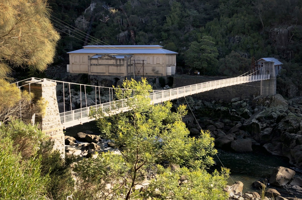
Duck Reach Hydro-Electric Power Station
To facilitate safer pedestrian access to the power station a second suspension bridge was constructed creating a permanent link across the gorge.
With a greater demand for electricity, partly triggered by the city’s introduction of an electric tram and the city’s increasing rollout of electric street lighting, the power station was upgraded to double its output and by 1910 it was producing, for its time, a considerable two megawatts of power.
The Big Flood
Even though the power station was built high above the river, the planners could not have anticipated the events that unfolded in the December of 1929. Unprecedented and persistent heavy rain followed a long dry spell flooding much of Tasmania’s low-laying land. The torrent of water forcing its way through Cataract Gorge, compounded by the merging of the flooded North and South Esk Rivers and the tidal Tamar River, raised the water at Duck Reach by 9.5-metres destroying the power station and sweeping away both suspension bridges. Despite such destruction the urgent need for power saw the station being quickly rebuilt and power was again being generated in 1930.
The Duck Reach suspension Bridge wasn’t rebuilt until 1939 but was again swept away by floods in 1969. It wasn’t until 1995 that the bridge was rebuilt following the original design and it stands to this day.
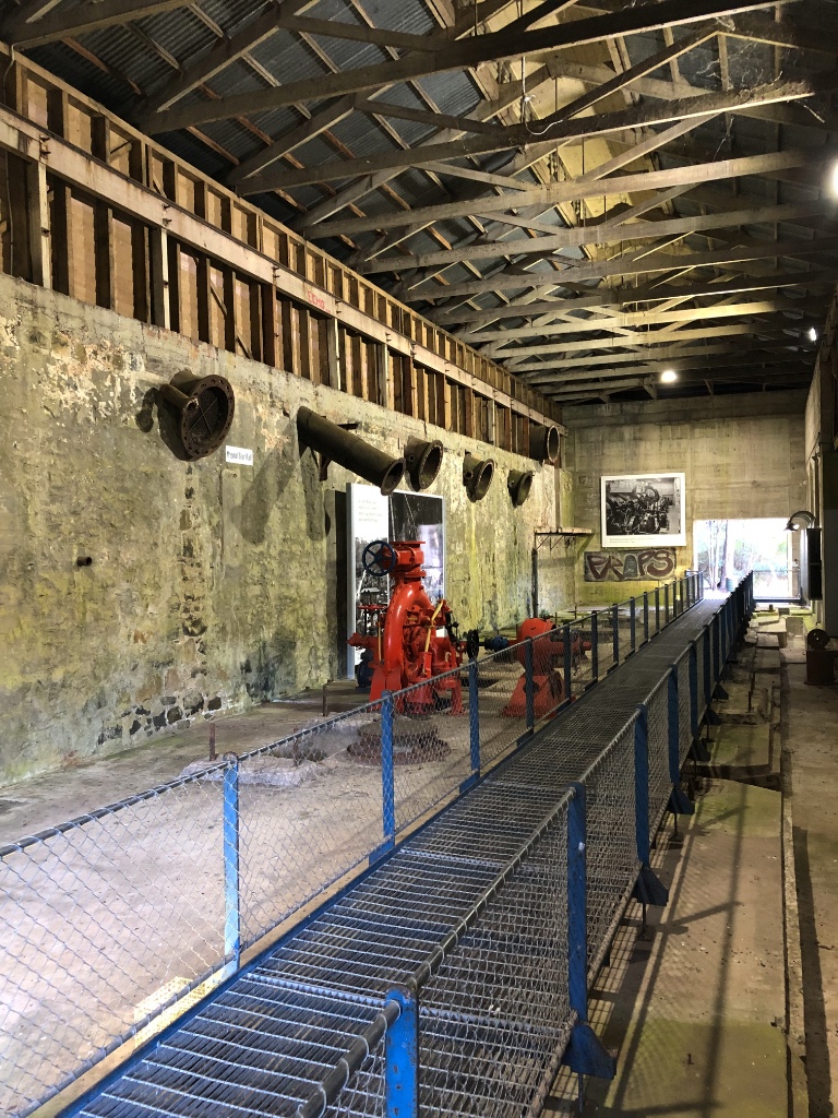
Duck Reach Power Station – now disused
More Power!!
Even following the plants upgrade the increasing demand for electricity was greater than the plant could provide and by 1934 the City of Launceston was also purchasing electricity from the Tasmanian Hydro-Electric Commission. By the early 1950’s the Duck Reach station’s days were numbered and was eventually decommissioned in 1955 when it was superseded by the new Trevallyn Dam Power Station. With the turbines and pipework removed the building remained derelict for the next 40-years until, on the centenary of it first becoming operational, it was re-opened as a museum and interpretation centre for visitors to enjoy.
A Grand Day Out
There’s plenty to see and do at Cataract Gorge for the family and walkers alike. It is a great day out combining great scenery, history and exercise and even a little daring for those who prefer their bridges to stay stationary as they walk over them.