
While planning our trip around Tasmania we saw two travel shows featuring a high-powered boat that ploughs its way through the waves along the eastern coast of the Tasman Peninsula. Passing sea caves, waterfalls, pinnacles and giant vertical cliffs, we decided it was a must do and what a ride it was.
The Yellow Boat
Bruny Island Cruises is just one of Robert Pennicott’s Tour options and part of Pennicott’s Tasmanian Wilderness Journeys. Our journey started at their Port Arthur office where we were advised to wear multiple warm layers and a beanie and to climb into the provided waterproof and wind proof full-length jacket once on the boat, a task easier said than done. Today the offshore wind was favouring a start from the small port of Pirates Bay so we all climbed aboard the Pennicott’s bus for the 15-minute drive north.
Doo Town
The jetty is accessed via the small and somewhat comically named settlement of Doo Town. In 1935 architect Eric Round unintentionally began a custom when he placed a name plate on his weekend property ‘Doo I’. His neighbour joined in with ‘Doo Me’ followed by ‘Doo Us’ from another neighbour. And it continues today with most homes being named in similar style. Among the many are; Doodle Doo, Wee Doo, Rum Doo, Doo Little and ‘Love Me Doo’.

We couldn’t have chosen a better day for a cruise with a clear blue sky and very little wind. We’d actually been keeping an eye on the weather and wind charts for a while and brought our booked trip forwards by two days for more favourable weather.
All Aboard
Our boat was one of two setting out on a 3-hour trip from Pirates Bay heading south along the coast, around the peninsula and then north through Maingon Bay up to Stewart Bay. Each boat seats 43-people and is powered by three 250hp outboard motors. That means these custom designed ‘Yellow Boats’ are quick, very quick, and can easily cut through heavy seas and a big swell. To ensure everyone onboard gets a good view the seats are tiered and safety belts on each ensure everyone stays onboard! Having a somewhat aged back and hips we were advised to sit right at the back for a smoother ride. It also meant we were right inline for the spray thrown by the boat when turning against the wind.
After a safety briefing we were off powering out to sea before turning south and following the coastline and the enormous vertical sea cliffs rising up to 300-metres above the sea. Much of the coastline is comprised of Jurassic Dolerite, one of the toughest known rocks, and splits into vertical columns rather than softly erode by the pounding action of waves. This allows sea caves to form and that is exactly where we next took a close-up view. On suitable days the boat can take you right into some of the caves but thankfully today wasn’t one of them – a recent rockfall made it unsafe.

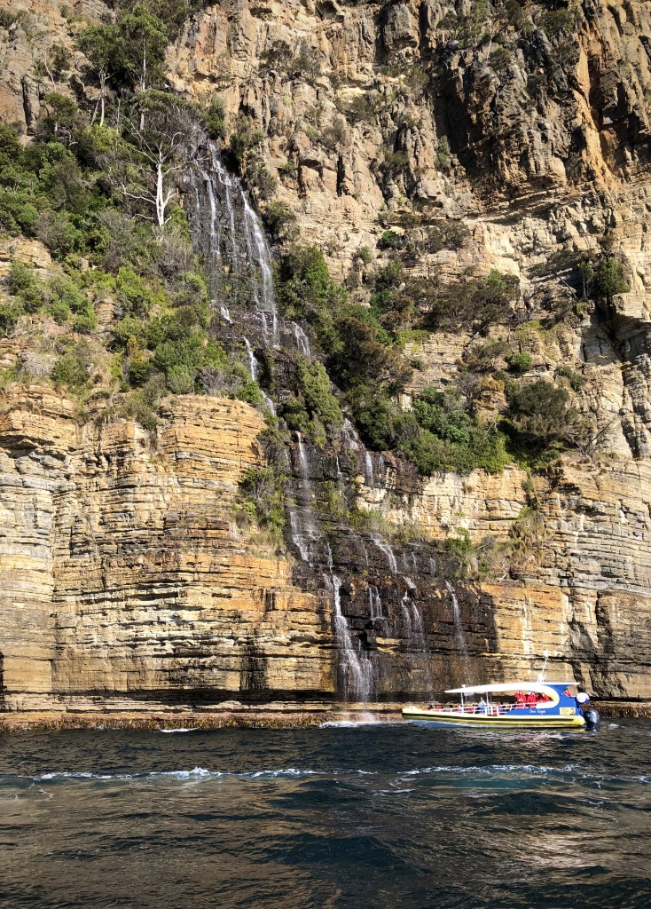
Waterfall Bay
Next up was the waterfall at Waterfall Bay cascading over 200-metres to the sea. At each stop our Captain, Ben, a maritime encyclopaedia, explained how each rock feature formed, the types of wildlife we could see, walks along the cliffs we could enjoy later and the Aboriginal history of the region. At each stop Ben keeps the boat turning to ensure everyone gets a clear view and the opportunity to take a photograph.
Fortescue Bay
Part of Tasman National Park, Fortescue Bay, also known as Baje Dolomien, was once a site of timber milling in the early 1900’s and later as a sheltered port for fishing vessels. Today it is a popular camping destination but also a haven for the Australian Fur Seal once hunted for their skins. And it was for the seals we were stopping in the bay to take a closer at. Completely unfazed by our approach – taking just a quick inquisitive look while they enjoy the warmth of the sun.

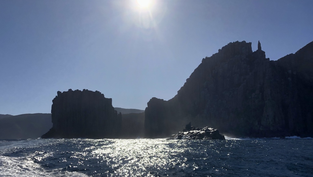
Cape Hauy
Heading further south and racing across Fortescue Bay we approach Cape Hauy. The cape was named in 1802 by French botanist François Péron after the mineralogist Rene Just Hauy, who went on to establish the science of crystallography, a technique later developed to discover the structure of DNA.
Cape Hauy is home to several outstanding rock features jutting straight up from the Tasman Sea. Two giant Dolerite bluffs known as The Lanterns, narrowly separated by the sea, were once joined as a single peninsula. In more recent times, geologically speaking, they formed sea arches before collapsing to form what we see today. On land The Lanterns mark cape one of the Three Capes Walk, a 48-km, 4-day trek along the East coast of the Tasman Peninsula.

Partly obscured by the Lanterns are two further rock features – sea stacks – that come into full view after rounding Cape Hauy. Named by Tim Christie after climbing both stacks in 1965, the Candlestick is a huge column of Dolerite rock offering less of a challenge then its neighbour the Totem Pole but still an extreme climb with a serious swell waiting in the sea below for the unfortunate… and the real possibility of sharks approaching for a closer look. The 65-metre tall Totem Pole is by far the most serious of the climbs with a base just 4-metres across, judders when pounded by waves and for added discomfort, it sways in the wind. Unbelievably the Totem Pole can be climbed without the aid of ropes as was first demonstrated by American Mark Anderson in 1995.

What makes Cape Hauy all the more impressive is the sheer height of the cliffs. At 300-metres these are not only the highest sea cliffs in Australia, they are the highest in the southern hemisphere.
Looking for Whales
Perhaps number one on most people’s lists is the opportunity to sight whales as they migrate along the coast. It was the right month for humpback whales heading north from the Antarctic but luck wasn’t with us on this day. Southern Right Whales are often sighted here too as are Killer Whales, Minkie Whales, Pilot Whales and an occasional ocean giant, the Blue Whale, at 33-metres the largest animal on earth.
Shortly after rounding Cape Hauy, flying right past us was an enormous seabird, a Shy Albatros* skimming the surface of the sea before wheeling high into the air and dropping back to skim the surface once more. It alerted everyone’s attention away from the towering cliffs to a disturbance in the water about 100-metres in front of us. Seabirds were swooping and diving into the water grabbing bait fish in a feeding frenzy. They were joined by flashes of silver in the sun as giant Blue Fin Tuna broke the surface chasing the bait while Shearwaters picked out those trying to escape. And flying among them were several Albatrosses hoping for an easy catch. It was an amazing sight that we were so fortunate to have had an encounter with. It would have been even better to see a whale today but we were happy to settle for this awesome display of nature.

Skirting the southern most point of the Tasman Peninsula and rounding Cape Pillar, the final cape on the Three Capes Walk, we passed through Tasman Passage, which separates Cape Pillar and Tasman Island. It was here that we were most exposed to the winds sweeping all the way from the Antarctic and an increasing swell. The often wild seas here are the reason that a lighthouse was constructed 240-metres above the sea on top of Tasman Island.
Tasmania’s Alcatraz
The 29-metre light tower was constructed in 1905 from steel panels hauled to the top of the cliff and bolted together. It began operating the following year but soon became likened to ‘Alcatraz’ by the lighthouse keepers. It was a highly unpopular station due to its isolated position, regular storms and its difficult and dangerous access. During the days when the lighthouse was manned it was a challenge just to get from a boat onto land but that required a landing stage on a neighbouring rocky outcrop, a flying fox to cross to the island and then a hair-raising 200-metre winch to the top. Large swells often made the fortnightly deliveries impossible when supplies couldn’t be dropped off, which led the lighthouse keepers to grow their own vegetables in the highly fertile soil. They also kept cattle and sheep, which sustained the lighthouse keepers and their families.
The Tasman Island lighthouse is the highest still operating in Australia and the last to be built in Tasmania. The storms and winds were often so severe that the structure used to vibrate regularly destroying the delicate mantles and occasionally dislodging the highly toxic mercury on which the light’s optics floated. After 71-years as a staffed station, the lighthouse was automated in 1977 and then converted to use solar power in 1991.
The last leg of our wilderness cruise saw us pounding through the waves and swell alongside the enormous sea cliffs of Black Head before entering the calmer waters of Port Arthur, past Point Puer with views over to the famous Port Arthur Historic Site, which was home to many of the convicts transported from the UK during the 1800’s.
Stewart Bay Harbour was the final stop where a fairly steep 500-metre walk leads back to Pennicott’s office, the point from where we started our adventure and where we said goodbye to our bright red waterproofs.
This was by far the most exciting experience of our trip around Tasmania to this point. The boats are fast and very stable, the scenery stunning and, although quite expensive, it was worth every cent and couldn’t be recommended more highly.
* The Shy Albatross is the only albatross that breeds in Australian waters and within the Australasian region. It is smaller than the Wandering Albatross with a wingspan of between 2 and 2.5-metres. Flying close to shore and often into bays and harbours, it wanders from subtropical to sub-Antarctic oceans.
