Situated on the Northeast coast of Tasmania and stretching from Eddystone Point to Binalong Bay, the Bay of Fires is a stunning mix of turquoise water, powdery white beaches and orange tinted granite boulders.
Named by British Captain Tobias Furneaux* in 1773 after observing fires lit by aboriginal people along the coast. Furneaux’s ship, HMS Adventure, was sailing as part of Captain Cook’s second exploration of the pacific before becoming separated.
Bring on the Colour
The orange colour is caused by lichen** from the Hymeneliaceae family. It is a common occurrence on the granite rocks and boulders in the northeast of Tasmania, but is particularly vibrant within the Bay of Fires region.
Lichen coated boulders – Bay of FiresThe Gardens – Bay of Fires
Parking is limited along the Bay of Fires coastline with the largest parking area situated at The Gardens. There are small areas where you can pull-off the narrow road but we’d recommend getting there early.
For photography, the early morning and late evening light is best when the orange lichen appears to glow.
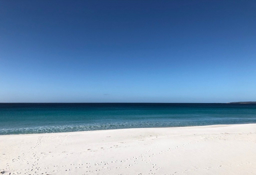
Binalong Bay
The powdery white beach between The Gardens and Binalong is perfect for a gentle walk. Humpback Whales can be spotted here from May to July as they head north to warmer waters and again between September and November when they return south to the Antarctic.
Turquoise waters of Binalong Bay
*Tobias Furneaux was one of the first men to circumnavigate the world in both directions.
** Lichens are a combination of algae and fungus that live in a symbiotic relationship. The algae gathers energy from the sun by photosynthesis providing food for the fungus, while the fungus creates a protective environment for the algae to thrive.
Located within Freycinet National Park, The Hazards are a mountain range on Tasmania’s east coast and gateway to one of the most famous beaches in the world.
Beauty in Pink
Anyone touring around Tasmania, and with the remotest interest in geology, will notice a change in the mountains on the Freycinet peninsula from the grey granite, black basalt, dolerite and sandstone of much of the state’s mountainous regions. As you approach the Hazards via Coles Bay you cannot help but notice their very distinct pink hue and more so in the evening under the setting sun.
Setting sun on the Hazards
Long, long Ago
The granite mountains, believed to have been named after African-American Whaler Captain Richard Hazard, are comprised of a mineral called Orthoclase – a pink form of feldspar that owes its colour to another mineral, iron.
The Hazards from Coles Bay
Around 60-million years ago volcanic activity beneath what is now Tasmania, pushed magma upward lifting the land hundreds of metres above sea level creating the Freycinet peninsula. During the same period the land to the west of the peninsula sank forming Great Oyster Bay. As the magma slowly cooled under pressure the Orthoclase formed into the large rectangular crystals that are typical of the rock, granite.
Over the following millions of years the softer ground above the granite eroded away exposing the rock to weathering by ice, rain and wind that has resulted in the giant rounded boulders that now litter the mountains. Today the Hazards stand at a shadow of their former height but still reach an impressive 485-metres above the sea.
Freycinet National Park
Much of the Freycinet peninsula falls within the bounds of Freycinet National Park* with the only access being via a single narrow, and not very well maintained road. Credit, though, is due for the excellent, and unusually large, National Park Visitor Centre, where a large number of park guides and leaflets about the region and activities can be found as well as a good selection of books, outdoor clothing, local crafts and souvenirs.
The distant Hazards Range from Swansea
Time for a Walk
We had been looking forward to exlploring the Freycinet region again following a previous visit in 2008. On that occasion the weather wasn’t in our favour with light rain and low cloud setting in just as we got to a major viewpoint. This time, however, the sun was shining and the sky was mostly clear, perfect walking weather despite the cool late autumn wind.
Our walk was the shortest within the park but with a view worth every step, and ache, up the often steep climb. In 2008 the same track between Mount Amos and Mount Mayson was best described as ‘rough’ with a steep climb on a slippery gravel path interspersed with sharp rocks ideal for tripping the unwary. Now, however, sturdy steps have evened out the steeper sections making the upward path easier, though still requiring a fair amount of effort. Several ‘new’ viewpoints have also been added looking back over Coles Bay towards the distant coastal town of Swansea.
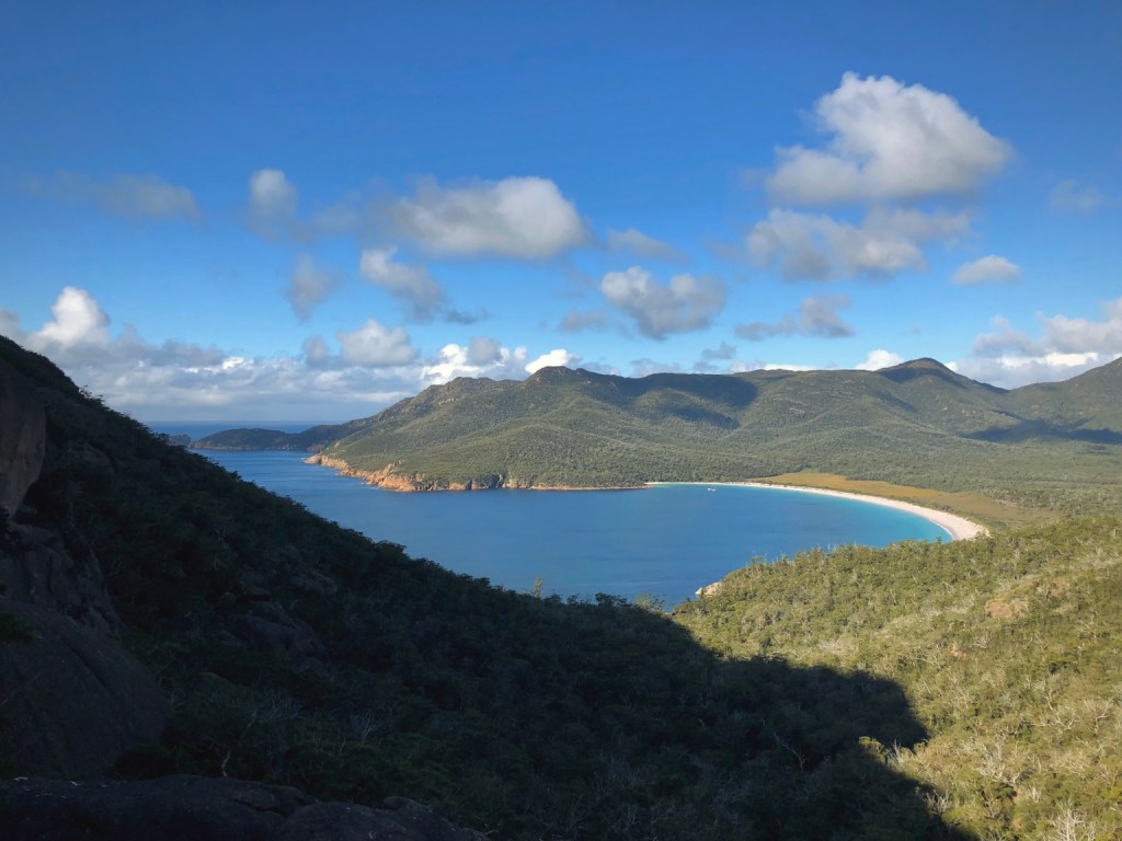
Wine Glass Bay from the Lookout
The higher you climb the larger the giant granite boulders become and in places you are walking among and between them towering over you. But there is a very worthy reward for the 45-minute climb when you reach the top of the pass – for this is the Wine Glass Bay Lookout Walk and from here, as the name suggests, you get the most amazing view of the world famous Wine Glass Bay. All the effort to arrive at the lookout weighed down by a heavy camera bag was worth every step. The lookout, too, had been updated with additional platforms giving greater access to the increasing number of walkers being attracted to the peninsula.
1,000 Steps Too Many
We had considered the extended walk that leads down to the white sand of Wine Glass Bay’s beach but we had second thoughts after reading more about the terrain. Access to the beach requires navigating a far steeper track and includes around 1,000 steps down and back to return to the viewpoint. At the end of the day it is just another of the many beautiful white beaches with turquoise water along the east coast of Tasmania and its ‘fame’ due to its curved shape and remote seclusion. So, after several photographs and a chat with a couple of fellow travellers, we headed back down the quite unique one-way track, which separates the freshly rested from the newly exhausted heading uphill.
People often ask, ‘what is the origin of the bay’s name?’, and no one is quite certain. The most preferred, and most pushed by marketeers, relates to the similarity of the bay’s shape to that of a wine glass, but there is a darker and more likely offering, a bloody one, which is where our whaling Captain Richard Hazard features once again.
In the early 1800’s whaling was a significant contributor to Tasmania’s fortunes and much of that was along the east coast of the state. Whaling stations were a common site where spotters would take to the high ground looking for the migrating whales, sending out the boats to harpoon any unfortunate passing whale and dragging them back to the shore-based stations for ‘processing’. The whale’s baleen was used to stiffen corsets and the rings of the fashionable British ladies’ dresses, while whale oil, extracted from the blubber powered the dim lights in Victorian houses and an extremely fine oil for lubricating clocks, watches and the machines driving the booming Industrial Revolution.
A Bloody Past
The more likely origin of Wine Glass Bay’s name, however, is related to the colour of the deeply blood stained water and beach during the whaling season rather than the shape of the bay. Imagine too the putrid stench of boiling blubber and the rotting carcass’s of whales. There could not be a greater contrast to how the pristine bay appears today.
*As with all National parks in Tasmania, a National Parks Pass is required for vehicles entering Freycinet National Park. Passes are available from all National Parks Visitor Centres in Tasmania as well as from the automated machines in Freycinet National Park’s car parks.
While planning our trip around Tasmania we saw two travel shows featuring a high-powered boat that ploughs its way through the waves along the eastern coast of the Tasman Peninsula. Passing sea caves, waterfalls, pinnacles and giant vertical cliffs, we decided it was a must do and what a ride it was.
The Yellow Boat
Bruny Island Cruises is just one of Robert Pennicott’s Tour options and part of Pennicott’s Tasmanian Wilderness Journeys. Our journey started at their Port Arthur office where we were advised to wear multiple warm layers and a beanie and to climb into the provided waterproof and wind proof full-length jacket once on the boat, a task easier said than done. Today the offshore wind was favouring a start from the small port of Pirates Bay so we all climbed aboard the Pennicott’s bus for the 15-minute drive north.
Doo Town
The jetty is accessed via the small and somewhat comically named settlement of Doo Town. In 1935 architect Eric Round unintentionally began a custom when he placed a name plate on his weekend property ‘Doo I’. His neighbour joined in with ‘Doo Me’ followed by ‘Doo Us’ from another neighbour. And it continues today with most homes being named in similar style. Among the many are; Doodle Doo, Wee Doo, Rum Doo, Doo Little and ‘Love Me Doo’.
Safety Briefing
We couldn’t have chosen a better day for a cruise with a clear blue sky and very little wind. We’d actually been keeping an eye on the weather and wind charts for a while and brought our booked trip forwards by two days for more favourable weather.
All Aboard
Our boat was one of two setting out on a 3-hour trip from Pirates Bay heading south along the coast, around the peninsula and then north through Maingon Bay up to Stewart Bay. Each boat seats 43-people and is powered by three 250hp outboard motors. That means these custom designed ‘Yellow Boats’ are quick, very quick, and can easily cut through heavy seas and a big swell. To ensure everyone onboard gets a good view the seats are tiered and safety belts on each ensure everyone stays onboard! Having a somewhat aged back and hips we were advised to sit right at the back for a smoother ride. It also meant we were right inline for the spray thrown by the boat when turning against the wind.
After a safety briefing we were off powering out to sea before turning south and following the coastline and the enormous vertical sea cliffs rising up to 300-metres above the sea. Much of the coastline is comprised of Jurassic Dolerite, one of the toughest known rocks, and splits into vertical columns rather than softly erode by the pounding action of waves. This allows sea caves to form and that is exactly where we next took a close-up view. On suitable days the boat can take you right into some of the caves but thankfully today wasn’t one of them – a recent rockfall made it unsafe.
Tasman Arch
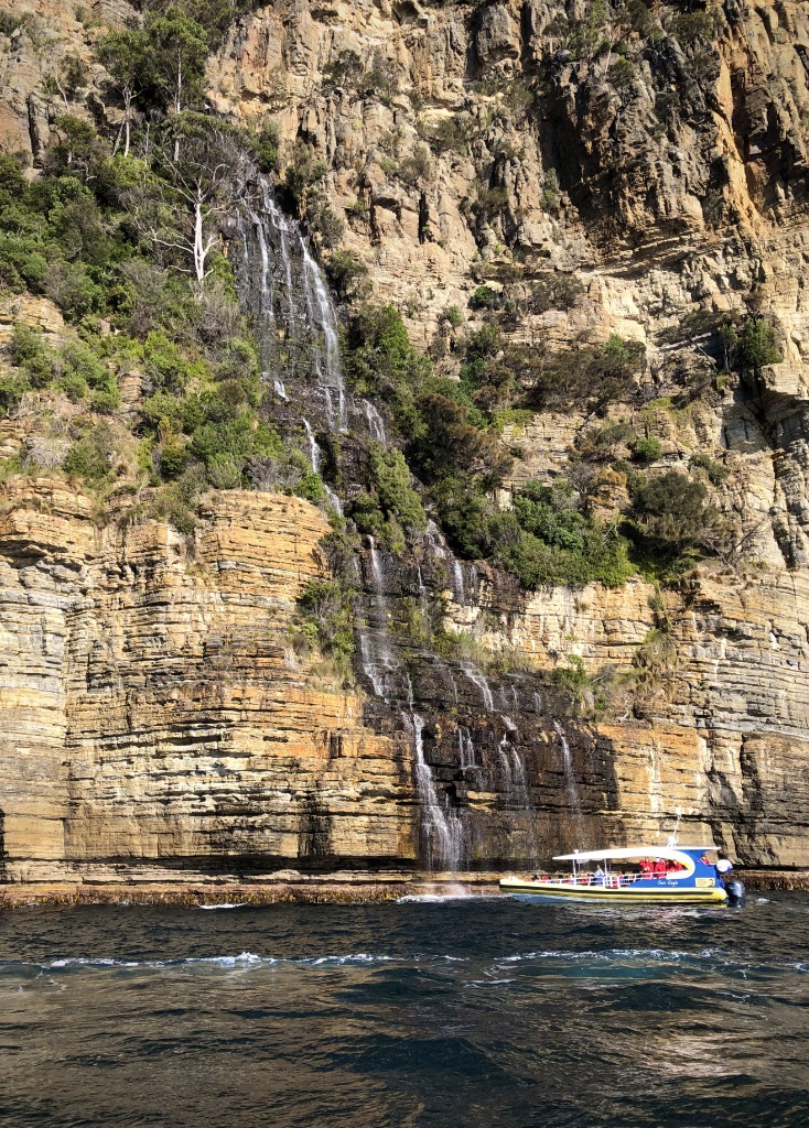
Waterfall Bay
Next up was the waterfall at Waterfall Bay cascading over 200-metres to the sea. At each stop our Captain, Ben, a maritime encyclopaedia, explained how each rock feature formed, the types of wildlife we could see, walks along the cliffs we could enjoy later and the Aboriginal history of the region. At each stop Ben keeps the boat turning to ensure everyone gets a clear view and the opportunity to take a photograph.
Waterfall Bay
Fortescue Bay
Part of Tasman National Park, Fortescue Bay, also known as Baje Dolomien, was once a site of timber milling in the early 1900’s and later as a sheltered port for fishing vessels. Today it is a popular camping destination but also a haven for the Australian Fur Seal once hunted for their skins. And it was for the seals we were stopping in the bay to take a closer at. Completely unfazed by our approach – taking just a quick inquisitive look while they enjoy the warmth of the sun.
Australian Fur Seal
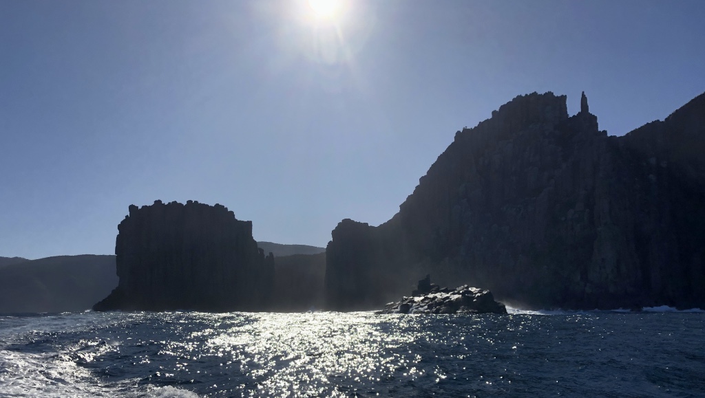
Cape Hauy
Heading further south and racing across Fortescue Bay we approach Cape Hauy. The cape was named in 1802 by French botanist François Péron after the mineralogist Rene Just Hauy, who went on to establish the science of crystallography, a technique later developed to discover the structure of DNA.
Cape Hauy is home to several outstanding rock features jutting straight up from the Tasman Sea. Two giant Dolerite bluffs known as The Lanterns, narrowly separated by the sea, were once joined as a single peninsula. In more recent times, geologically speaking, they formed sea arches before collapsing to form what we see today. On land The Lanterns mark cape one of the Three Capes Walk, a 48-km, 4-day trek along the East coast of the Tasman Peninsula.
The Lanterns
Partly obscured by the Lanterns are two further rock features – sea stacks – that come into full view after rounding Cape Hauy. Named by Tim Christie after climbing both stacks in 1965, the Candlestick is a huge column of Dolerite rock offering less of a challenge then its neighbour the Totem Pole but still an extreme climb with a serious swell waiting in the sea below for the unfortunate… and the real possibility of sharks approaching for a closer look. The 65-metre tall Totem Pole is by far the most serious of the climbs with a base just 4-metres across, judders when pounded by waves and for added discomfort, it sways in the wind. Unbelievably the Totem Pole can be climbed without the aid of ropes as was first demonstrated by American Mark Anderson in 1995.
The Candlestick and The Totem (left of image)
What makes Cape Hauy all the more impressive is the sheer height of the cliffs. At 300-metres these are not only the highest sea cliffs in Australia, they are the highest in the southern hemisphere.
Looking for Whales
Perhaps number one on most people’s lists is the opportunity to sight whales as they migrate along the coast. It was the right month for humpback whales heading north from the Antarctic but luck wasn’t with us on this day. Southern Right Whales are often sighted here too as are Killer Whales, Minkie Whales, Pilot Whales and an occasional ocean giant, the Blue Whale, at 33-metres the largest animal on earth.
Shortly after rounding Cape Hauy, flying right past us was an enormous seabird, a Shy Albatros* skimming the surface of the sea before wheeling high into the air and dropping back to skim the surface once more. It alerted everyone’s attention away from the towering cliffs to a disturbance in the water about 100-metres in front of us. Seabirds were swooping and diving into the water grabbing bait fish in a feeding frenzy. They were joined by flashes of silver in the sun as giant Blue Fin Tuna broke the surface chasing the bait while Shearwaters picked out those trying to escape. And flying among them were several Albatrosses hoping for an easy catch. It was an amazing sight that we were so fortunate to have had an encounter with. It would have been even better to see a whale today but we were happy to settle for this awesome display of nature.
Tasman Island and access winch
Skirting the southern most point of the Tasman Peninsula and rounding Cape Pillar, the final cape on the Three Capes Walk, we passed through Tasman Passage, which separates Cape Pillar and Tasman Island. It was here that we were most exposed to the winds sweeping all the way from the Antarctic and an increasing swell. The often wild seas here are the reason that a lighthouse was constructed 240-metres above the sea on top of Tasman Island.
Tasmania’s Alcatraz
The 29-metre light tower was constructed in 1905 from steel panels hauled to the top of the cliff and bolted together. It began operating the following year but soon became likened to ‘Alcatraz’ by the lighthouse keepers. It was a highly unpopular station due to its isolated position, regular storms and its difficult and dangerous access. During the days when the lighthouse was manned it was a challenge just to get from a boat onto land but that required a landing stage on a neighbouring rocky outcrop, a flying fox to cross to the island and then a hair-raising 200-metre winch to the top. Large swells often made the fortnightly deliveries impossible when supplies couldn’t be dropped off, which led the lighthouse keepers to grow their own vegetables in the highly fertile soil. They also kept cattle and sheep, which sustained the lighthouse keepers and their families.
The Tasman Island lighthouse is the highest still operating in Australia and the last to be built in Tasmania. The storms and winds were often so severe that the structure used to vibrate regularly destroying the delicate mantles and occasionally dislodging the highly toxic mercury on which the light’s optics floated. After 71-years as a staffed station, the lighthouse was automated in 1977 and then converted to use solar power in 1991.
Black Head
The last leg of our wilderness cruise saw us pounding through the waves and swell alongside the enormous sea cliffs of Black Head before entering the calmer waters of Port Arthur, past Point Puer with views over to the famous Port Arthur Historic Site, which was home to many of the convicts transported from the UK during the 1800’s.
Stewart Bay Harbour was the final stop where a fairly steep 500-metre walk leads back to Pennicott’s office, the point from where we started our adventure and where we said goodbye to our bright red waterproofs.
This was by far the most exciting experience of our trip around Tasmania to this point. The boats are fast and very stable, the scenery stunning and, although quite expensive, it was worth every cent and couldn’t be recommended more highly.
* The Shy Albatross is the only albatross that breeds in Australian waters and within the Australasian region. It is smaller than the Wandering Albatross with a wingspan of between 2 and 2.5-metres. Flying close to shore and often into bays and harbours, it wanders from subtropical to sub-Antarctic oceans.
As part of the government’s 19th century plan to rid Britain of its less desirable and criminal population, convicted criminals were transported to one of a number of penal colonies.
Following the American War of Independence Britain no longer had the option of sending its convicts to America. So from 1788, forced transportation meant incarceration in the Australian colonies. For many that meant doing time at Port Arthur.
Port Arthur Historic Site
Trivial crimes by the standards of today, stealing a loaf of bread to feed a starving child could lead to a prison sentence. Often the offenders were from the slums of the big cities with theft being their only means of survival. With Britain’s prisons overflowing, convicted criminals, regardless of their offence, often found themselves facing transportation to the new convict colonies in Australia. Men, women and even children discovered this was mostly a one way journey. Few ever returned home.
Severe as the sailing across the oceans was, the convicts were to face far worse once they arrived in Australia. Hard labour in harsh conditions, mosquitoes, leeches, disease, floggings, solitary confinement and being shackled often for more than a year with heavy leg-irons that could only be removed by hammer and chisel. New arrivals were given the most punishing and strenuous work as ‘Tree-getters’ and dockyard workers in an attempt to break them and conform to the colony’s strict regulations.
Port Arthur Historic Site
Named after Governor George Arthur in 1830 and conceived as a penal station, Port Arthur began as a timber production centre using convict labour. Timber mills were constructed to process the logs that were being felled by ‘tree-getters’ for use in government projects. By 1833, however, Port Arthur had become a punishment centre for repeat offenders from around the Australian colonies.
Discipline by punishment, training and education was designed to rehabilitate the convicts but, as today, while some went on to live productive, skilled and peaceful lives many continued to reoffend and often spent time committed to solitary confinement in cells only just large enough for a hammock.
Confinement Cells
Education led to useful skills such as clothes, shoe, furniture and brick making as well as masonry to produce stone for the church and prison buildings, while the more trusted worked at the Dockyard boat building. More than seventy convicts worked in the dockyard mostly as unskilled labour under the direction of skilled civilian shipwrights. Often they would be working neck-deep in cold water. In total the convicts produced around 150 small open-top boats and 16 large-decked ships between 1834 and 1848.
The Treadmill
To feed the growing population of Port Arthur a water-powered flour mill and granary was constructed in 1842. It included a giant treadmill large enough for 56 convicts to operate at once. The treadmill was both a form of providing energy for turning the grind stones in the flour mill but also as punishment by hard and repetitive labour. It wasn’t unusual for a convict to misplace a foot on the treadmill, which usually resulted in mutilation of a limb. Bad as that was, further punishment was often inflicted for not returning to work the next day. A flogging carried out by another convict was a common punishment.
Getting water to the flour mill was troublesome. Evaporation and leakage of the aqueduct and millrace and regular lack of rain meant operation of the mill was far less successful than anticipated and eventually it was used only intermittently.
Port Arthur Penitentiary
By 1849 over 2,000 people including convicts, civilian staff and soldiers were based at Port Arthur. However, with the cessation of transportation in 1853, fewer transportees were arriving, instead, being a secondary punishment station, sentenced men from within the convict penal colonies were sent to Port Arthur further increasing the population to almost 3,500. Although large tracts of land had been turned over for cultivation as well as cattle and sheep being reared for meat in an attempt to be self sufficient, the station was still heavily dependent on supplies from the capital, Hobart.
Solitary Confinement
By the late 1840’s the authorities realised that harsh punishment just made the convicts tougher. It was a convict sign of defiance that no cries of pain were made during floggings even when close to death. So an even more savage form of punishment was introduced – Solitary Confinement and for those still unmanageable there was the ‘Dark Cell’ where the prisoner was kept in total darkness and silence for up to 30-days.
The Separate Prison
In a belief that psychological punishment was more effective, the Separate Prison was built where convicts were isolated from each other and held in total silence. The only time they were permitted to speak or communicate in any form was when questioned by prison guards or to the visiting clergyman. When out of their cells they wore hoods with just slits for their eyes so they were unable to recognise each other. Any breach of the prison rules meant time spent in the Dark Cell.
The isolation broke many men, either mentally destroyed, permanently withdrawn or psychotic and so an asylum was built to house them and other ‘lunatics’ from the other colonies.
In 1857, to cope with the increasing convict population, the granary and flour mill were converted into a penitentiary with workshops, a blacksmith and a steam-powered sawmill added. The lower floor of the building housed 136 confinement cells. On the ground floor men were constrained by heavy leg-irons weighing up to 13kg, while those on the first floor wore lighter irons. And on the uppermost floor bunks we’re constructed for 348 men.
No escaping the Dog Line
About 20km north of Port Arthur the Tasman Peninsula narrows to an isthmus just 100-metres wide known as Eaglehawk Neck. In the early part of the 1830’s, Governor Arthur stationed sentries at the Neck to prevent escapees reaching the mainland of Tasmania. One of the stationed officers suggested placing nine dogs with lamps across the isthmus, not to attack escapees but to alert the sentries of suspicious noise or activity that the sentries could not hear above the noise of the sea. Mostly successful, the number of dogs was further increased to eleven when platforms for the dogs were placed in the sea to prevent any convict’s attempt to wade around the line.
The Dog Line at Eaglehawk Neck
The Dog Line was a good deterrent, as was the rumour spread by the officers that the sea was infested by sharks, and it remained in place until Port Arthur was permanently closed.
Isle of the Dead
Situated within view of the colony is a small, tree covered island and the burial site of more than 1,100 people who died at the colony between 1833 and 1877. It’s more than a challenge to dig a grave in the island’s rocky ground and you have to wonder how so many remains were able to be buried here.
Distinction between the civilian staff, military and convicts continued even in death with the convicts being buried on the lowest ground of the island.
Closure
The settlement was finally closed in 1877 with the buildings and land auctioned-off to private buyers and a change from the name of Port Arthur to Carnarvon.
In all, 76,000 convicts were transported to Australia and held in colonies in Western Australia, Victoria, New South Wales and Tasmania.
Early Tourism
Very quickly after the closure and sale of the colony, curious tourists began to visit the site and by the 1920’s several of the convict buildings had been converted to museums. Recognising the importance of the convict history of Australia the Tasmanian state government began acquiring portions of the site from private owners and restored the Port Arthur name. Today more than 30-buildings, gardens and extensive ruins form the Port Arthur Historic Site and its importance to Australian history was recognised when in July 2010 the site was added to UNESCO’s World Heritage List.
What we see now, and the defining feature of the Port Arthur Historic Site, is the remains of the penitentiary building gutted by fire in 1897. Just the masonry and the metal bars across the windows survived the heat of the blaze. Many other buildings were also destroyed in the fire including the church, which was attended by up-to 1,100 convicts for the compulsory services held each Sunday.
Surviving Penitentiary Window
There is so much more to Port Arthur and it’s convict history and a wealth of information is presented on display in the Visitor Centre and the small museum in the ‘Separate Prison’ building. And, of course, through online resources. However one issue we found in both the visitor centre and prison building was the very low light level and highly reflective copper panels carrying all the descriptive text. We gave up trying to read them.
A lone Gunman
Of course no account of Port Arthur is complete without mentioning the dreadful events of April 28th 1996 when a lone gunman, armed with two semi-automatic rifles, shot dead 35 innocent people and injured 23 others. Twenty of those killed were in and adjacent to the Broad Arrow Cafe at Port Arthur Historic Site. In the coach park the gunman continued shooting and killing including two children aged just three and six years.
The gunman, 29-year old Martin Bryant, remains in Risden Prison near Hobart serving concurrent life sentences for each person he murdered with no parole and an additional life sentence for the remaining 36 charges, which included 20 attempted murders.
The Broad Arrow Cafe was later dismantled leaving only the walls to form part of the memorial to those who tragically lost their lives. Such was the public and political outrage that strict new laws governing gun ownership were introduced. The Port Arthur massacre followed just six-weeks after a similar shooting in the Scottish town of Dunblane where 18 people were killed. Changes to gun ownership laws in the UK were introduced the following year.
Just 20-minutes by ferry from the Tasmanian mainland, Bruny Island is a wild and remote place with white sand beaches, turquoise water, magnificent sea cliffs and abundant wildlife. The island is marketed as a foodies paradise – so where’s the food?
Artisans
We had been greatly looking forward to our visit here following numerous TV travel and food shows highlighting the artisan cheese makers, bread bakers, wine makers, beer brewers, the artists, the writers and, of course, the unspoilt natural landscape. That list, however, didn’t include the tarmac road builders – much of the island’s roads are dirt roads, dusty when dry and muddy when wet.
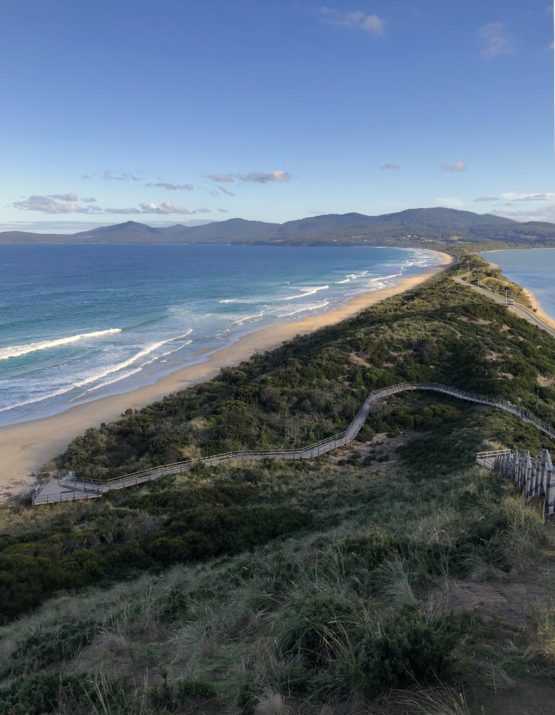
The Neck
The island is split into two – the North and South Islands are linked by a very narrow isthmus known as the Bruny Island Neck. The majority of accommodation and activities are located on the South Island, which includes our caravan site at Adventure Bay.
Truganini Lookout
Giving views of both the north and south islands as well the Tasmanian mainland, Truganini Lookout sits above the middle of Bruny Island Neck. Reached by 279 timber steps, the lookout is named after the Aboriginal woman Truganini (1812-1876) reportedly the last full-blooded aboriginal person to die in Tasmania. Believing she was the last of her pure race, she once declared, ‘I know that when I die the Museum wants my body’.
Prior to her death in Hobart, Truganini pleaded to the authorities for a respectful burial and asked that her ashes be scattered in the D’Entrecasteaux Channel, a region of great significance to her people, fearing that her body would be mutilated for scientific purposes just as her late husband had been.
Contrary to her request she was buried at the old female penitentiary. Her remains were later exhumed by the Royal Society of Tasmania, which was authorised by the government to take possession of her skeleton. However, it was on condition that her remains were not to be exposed to public view but ‘decently deposited in a secure resting place accessible by special permission to scientific men for scientific purposes’.
Truganini Lookout
Despite Truganini’s wishes and in violation of the government’s conditions, her remains were displayed in the Museum of Tasmania from 1904 to 1947. It wasn’t until 1974 that her wishes were finally honoured and her cremated remains were scattered in the D’Entrecasteaux Channel.
Her story is a sad one and highlights just how appallingly the Europeans treated the Aboriginal people of lunawanna-alonnah (Bruny Island). In memory of Truganini and the Nuenonne speaking people of the southeast, a cast bronze memorial was placed at the top of the lookout with a 360-degree view of what was rightfully their land.
Adventure Bay
To the east and south of the Neck is the sweeping Adventure Bay. It has more than a few connections with the famous early explorers and first off is Abel Tasman who first sighted the bay in 1642 and tried to make land in his ship the Heemskerck. Abel’s ship was driven back by an offshore storm but in memory of his attempted landing, Abel named the bay ‘Storm Bay’. In 1773 Captain Tobias Furneaux anchored in the bay for five days and took the opportunity to rename the bay ‘Adventure Bay’ after the name of his ship HMS Adventure. Furneaux had been sailing alongside Captain Cook’s ship, HMS Resolution on Cook’s second voyage in search of The Great Southern Land – Australia, when he became separated from Cook. Furneaux noted the bay was ideal for resupplying ships with fresh water, fish and timber from the giant gum trees.
In 1777 Cook, in his ship Resolution, stopped to take on fresh water and eleven years later the infamous Captain Bligh* moored in the bay to resupply HMS Bounty. Having survived the famed mutiny on the Bounty, Bligh once again stopped in 1792 to resupply his latest ship HMS Providence. And in 1798 Matthew Flinders tried without success to enter the bay in his ship ‘Norfolk’.
Taking advantage of the largely sheltered bay, Europeans soon began to arrive and setup several whaling stations and sawmills forming a fledgling timber industry.
Two Tree Point – George Tobin 1792
Two Tree Point, which sits within Adventure bay, is still a source of fresh water and was used by Cook, Bligh and Furneaux to replenish their water supplies. Using the name of Cook’s ship, Bligh named the water source ‘Resolution Creek’. It is believed the two large eucalyptus trees that can be seen today are the same trees sighted in the late 1700’s and in a painting by Bligh’s 1792 Expedition’s Principal Artist, Lieutenant George Tobin.
Two Tree Point – Resolution Creek
Today Adventure Bay is a quiet tourist destination with access to several walks within South Bruny National Park, a well stocked general store, the Bligh Museum detailing Bligh’s association with the bay and Mary Bruny Cafe for a good coffee and great food.
Cheese and Beer
One of the few foodie retailers and artisans can be found at the Bruny Island Cheese Co. and Bruny Island Beer Co. both located at Great Bay. We tried the cheese tasting plate with three cheeses served with fresh crusty sourdough bread baked on-site and a delicious relish. Each cheese is hand made in the traditional way from the milk of their own cows in Huonville.
O.D.O. – a simple curd cheese that is just One Day Old
1792 – a pungent washed rind aged on Huon pine – strong and smoky
SAINT – a mild white mould cheese, our favourite
We didn’t try the beer tasting plate – it was tempting but we were still driving.
Bruny Island Chocolate Co.
Hidden behind a dense line of trees on Main Road at Alonnah, Bruny Island Chocolate Co. is a curious place. Hand made chocolates and fudge apparently made on-site but with no sign of any manufacturing, no tasting options and a clear preference to upsell by putting chocolates in decorated metal boxes and lining nearly every available shelf. By all appearances it is just a shop. We did buy a few covered bars and later discovered none of them were labeled.
And there’s More
There is a winery, a whisky distillery and the restaurant called Get Shucked on Bruny Island for those with a taste for Oysters. But we were expecting more for somewhere classed as a ‘foodies paradise’.
* The HMS Bounty was categorised by the Admiralty as a ‘Cutter’, the smallest form of warship, and as such it did not require the full rank of a post-Captain. Instead the ship and her crew were commanded by a Lieutenant, the only commissioned officer onboard, which meant Bligh was not the Captain of the Bounty as is often quoted. His conspirator and leader of the mutiny was acting-Lieutenant Fletcher Christian.
The ‘Cutter’ class of warship also did not require the usual attachment of Royal Marines whose role was to maintain order, a fact that Mr Christian clearly took advantage of.