The Taroona Shot Tower

An unusually tall stone tower, built in 1870, sits beside the Channel Highway at Taroona 12km south of Hobart. It’s purpose is not obvious. Is it a smoke stack for some Victorian industrial scale boiler, a fire watch tower, perhaps, or an old lighthouse watching over ships entering Hobart Harbour?

Taroona Shot Tower

It’s a Machine

It’s actually a Shot Tower, a machine of sorts, built to produce the lead shot fired from muskets. By any imagination the tower is not the first thing you would think of as being a machine of any design but innovation leads to success and that was certainly the case for Scots born Joseph Moir, Engineer, Architect, Carpenter and Overseer.

Once the tallest building in Australia, the tallest in Tasmania (until 1960) and believed still to be the tallest circular sandstone tower in the world, Taroona Shot Tower was built in just 8-months by two stonemasons to Moir’s design.

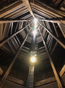
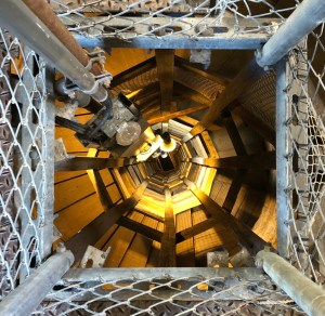
Standing almost 59-metres tall, 10-metres in diameter at the base and narrowing to 3.9-metres at the top, the tower’s impressive dimensions are deceptive. The adjoined stone building, which gives access to the shot tower, looks diminutive by comparison but is actually a substantial building in its own right. It’s only when standing within the tower that its true size can really be appreciated. Looking upward is more than a little daunting. Lining the walls of the tower is a circular wooden staircase comprising 318 shallow steps with a platform every 180-degrees and on some levels an open slot gives views of the increasing loftiness of the climb.

A long way to the top!

At the top of the tower, the original chimney pot has been removed and the roof made weather-tight. An external, circular metal platform and railing has been added providing excellent views of the Derwent River and surrounding countryside – at least to those brave enough!

Lookout below

Sitting to one side is the wood-fired cauldron originally used to melt a combination of lead, antimony and arsenic. Once molten the metal would have been poured into a steel colander suspended over the centre of the tower. Droplets of metal would begin to form and cascade down the length of the tower creating perfectly round spheres before hitting a tank of water at the base and cooling. The process took a lot of experimentation to perfect but finally produced successful shot on the 8th of September 1870 and continued to do so until 1905 when it was no longer commercially viable.

A long way down!

The size of the shot produced could be controlled to some extent by altering the size of the holes in the colander but it was not a perfect process. The size of the droplets varied with each pour requiring manual retrieval from the water tank and sorting the tiny shot in poor light by hand.

A Victorian tea shop first opened in the late 1800’s is still operating at the base of the tower. Each day they bake the lightest scones you’ll have ever eaten served with your choice of over 70-types of tea. They are among the best we have tasted throughout our travels around Australia and come very highly recommended.

Land of the Giants

You just can’t get enough of tall trees in this part of the world. If your neck has recovered from craning skywards after visiting the majestic tall trees in The Tarkine and Mount Field National Park, prepare yourself for the real giants here at Styx Tall Trees Conservation Area.

Finally Protected from Felling… for now

A long and bitter campaign by the Wilderness Society and Greenpeace to stop the continued felling of native trees within the conservation area was, thankfully, successful and in 2013 part of the Styx valley, where the largest and most ancient trees still grow, was added to the Tasmanian Wilderness World Heritage Area. However, successive Tasmanian governments have worked hard to reverse this hard fought protection for the benefit, not of mankind but the forestry industry.

Not ‘coincidentally’ the government agency ‘Forestry Tasmania’, trying to show its new, environmentally friendly concern for the ancient forests, has renamed itself ‘Sustainable Timber Tasmania’.

The ‘Bigger Tree’ – Tasmanian Mountain Ash

Remote Access

There are several walks within Styx Tall Trees Conservation area – none of them too challenging, but getting here we’d recommend a 4-WD or a car that you don’t mind receiving a few scratches here and there, possible punctures, wrecked shock-absorbers and a good coating of mud.

The turn-off from Gordon River Road leads to the 18km stretch of Styx Road, which is unsealed, winding and with plenty of potholes to navigate, as are possible fallen trees. Although Tasmania Parks & Wildlife Service does make regular inspections the road is actually maintained by the logging companies.

It should be noted that this is a remote location and there is no mobile phone reception. So be prepared in case of an emergency, leave a note to inform someone of your planned walk and expected return time and carry a snake/spider bite kit.

Styx Tall Trees Walk

The start of this walk is close to the signpost announcing you have arrived in the Big Tree Forest Reserve. A small area suitable for parking is available and gives the easiest access to see the ‘Big Trees’.

Eucalyptus regnans – 90-metres and still growing

A 1km loop over mostly flat ground. A partial board walk takes you past an enormous felled giant Mountain Ash tree (Eucalyptus regnans) covered in moss, as are most of the trees on this walk. The Mountain ash is the largest flowering plant in the world and by a long way – some exceeding 90-metres in height, a girth in excess of 20-metres and some more than 500-years old.

You will find some of the largest trees on this walk around the halfway point. Among them are two in particular, one named ‘The Big Tree’, being the tallest measured at that time but was later followed by one even taller and aptly named ‘The Bigger Tree’.

Lion’s Mane Fungi – Hericium Erinaceus

Among the decaying timber and ground cover of moss are many varieties of fungi and well worth a closer look as you follow the walk among ancient tree ferns. Keep an eye out too for several of the older trees that have some unusual fungi growing from them such as the Lion’s Mane mushroom.

Record Breakers

There is one tree further south, known as Centurion, that has reached the lofty height of 100.5-metres and continues to grow. It is the third tallest tree in the world and the tallest known hardwood tree on earth. It’s exact location has been kept quiet to protect it from trampling feet. Exceeded only by the giant Redwood Trees of the Californian coast of North America at 116-metres, the Mountain Ash is the tallest species of tree in the Southern Hemisphere.

Hygrocybe pseudograminicolor

Styx River Walk

Originally named ‘Sticks River’ by early settlers due to the jumble of fallen trees and branches obscuring views of the river, it was renamed ‘Styx River’ during an 1826-28 period of formalising names by the government.

The Styx River walk, though pleasant, is among less dense and less ancient growth leading down to the tumbling Styx River. Although several large Mountain Ash trees are visible on the track they are less impressive if you have already taken the Tall Trees Walk and less accessible to photograph. There is, however, a good undercover of Myrtle and tree ferns. It is a much drier walk underfoot but suitable footwear is still advisable, especially when wet.

Cortinarius metallicus

The Chapel Tree

Not the easiest Tree to find. The Chapel Tree is accessed 4km further along Styx Road from the Tall Trees Reserve where you then need to take a right turn and continue for a further kilometre to a fork in the road. Take the right fork and continue along the narrowing track for a final kilometre. From here look for a handmade sign pointing into the bush where a barely visible track leads. Follow the pink tape markers through bracken, low hanging branches and boulders placed among wetter patches and you’ll arrive at the Chapel Tree.

What makes this giant unique is the enormous base of the trunk. Years of decay has created an open cavity inside the trunk large enough, apparently, to hold fifteen people. It’s a brave person that stands inside the trunk of such an enormous tree knowing what is left of the tree’s decaying base is supporting such a staggering weight. But, of course, in the name of science adventure, I took a quick look.

The Chapel Tree

Hopefully being a little more remote, the Chapel Tree will be less visited and continue to grow for many, many more years.

If you are ever in this part of the Tasmanian Wilderness, this is a must visit to see some of the tallest trees in the world in their unspoilt habitat. Just don’t be off put by the few kilometres of destroyed forest that has been clear-felled as you drive along Styx Road into the Styx Valley.

Mount Field National Park

Formed by glaciers thousands of years ago, Mount Field National Park is one of Tasmania’s oldest national parks and reputed to be the most diverse. It also has one of Tasmania’s most impressive waterfalls – Russell Falls. It is with good reason Mount Field National Park was added to the Tasmanian Wilderness World Heritage Area in 2013.

Russell Falls

The national park is home to three cascading waterfalls with Russell Falls being the easiest to access and arguably the most impressive of the three. Situated just a short walk from the visitor centre through ancient tree ferns and towering Swamp Gums – the tallest flowering plant in the world, Russell Falls cascades over several levels of eroded bedrock to form a spectacular tiered waterfall. Although it had been quite wet recently the falls weren’t at their best, apparently.

Russell Falls – Mount Field National Park

Continuing along the trail, a side walk leads to a set of 200-steps to climb up to Horseshoe falls. Here a semicircular hollow provides a good viewpoint of the falls surrounded by tree ferns and moss covered boulders. Though nowhere near the height and width of Russell falls, Horseshoe falls is still impressive and, from photographs we have seen at the visitor centre, is very capable of putting on a big display after heavy rain or melting snow from the higher alpine region.

Horseshoe Falls – Mount Field National Park

Tall Trees Walk

Our walk continued along the Three Falls Track to an area known as Tall Trees. Here, among dense forest, are many of the giant swamp gums that you can stand beside and strain to look upward to the canopy high above. A Clinometer* has been setup so you can measure the height of one of the trees for yourself. A chart beside the Clinometer converts the angle you measure between the ground and the canopy of the tree giving the tree’s approximate height. The correct height is given behind a hinged flap on the chart.

Several of the trees in the this area are known to be in excess of 70-metres tall and 300 to 400-years old.

For those less able to climb the steps along this walk, a car park at Gate 2 is easily accessible from the visitor centre along Lake Dobson Road.

Lady Barron Falls

Lady Barron Falls – Mount Field National Park

Following the same track up and down and around smaller creeks eventually leads to a short diversion to Lady Barron Falls. Similar to Horseshoe falls but with more water, Lady Barron Falls was a bit of a disappointment after Russell Falls and not the easiest place to take a photograph from. It’s quite a long walk to get here if you follow the circular walk between each of the falls and still more than a third of the walk back to the visitor centre. However, the return walk is well worthwhile as it follows the Lady Barron Creek as it makes its way down to the Tyenna River. Beware though, the return leg includes an uphill flight of steps – all 239 of them!

Fungi Everywhere

Perhaps more than anywhere I have seen yet, Mount Field National Park during Autumn supports an enormous variety of fungi, many of which were new to me. At every turn you will see fungi and lichen growing on trees that have fallen and growing among the leaf litter.

Cortinarius archeri

After spotting a few species you may find yourself looking more attentively at the most brilliantly coloured or tiniest delicate fungi. Some that look like coral, some green or even blue and some that look like an alien creature. There is just so much to see but please do not disturb the fungi – they are an essential part of a healthy forest breaking-down fallen trees and branches and releasing nutrients and minerals back into the soil.

Beware – many of the fungi are poisonous and one in particular – the Death Cap (Amanita phalloides) is extremely toxic. It is responsible for 90% of mushroom related human fatalities world-wide. Ingesting as little as half of this apparently tasty and harmless looking mushroom can result in a slow and painful demise. Death usually follows an apparent but temporary recovery in as little as twelve hours as a result of permanent organ failure.

Left of Field

Left of Field – Music Night

Our campsite during our stay in the national park was the quirky ‘Left of Field Caravan Park’. It’s a great balance between the unspoilt beauty of the surrounding flora and fauna and the necessities of on-the-road life. But then it also has a fabulously stocked bar within a shipping container, a blazing fire to sit around and a live band on Friday nights. Our hosts, Adrian and Mel, are a wealth of knowledge, not just of the local area but much of Tasmania too. You will be made to feel very welcome.

Something’s stirring in the River

We had heard that platypuses can often be seen in the Tyenna River behind the caravan park. So, having always wanted to photograph one, we walked down to the weir and followed the riverside upstream. And right there in front of me was a platypus showing no interest at the long lens I was pointing at it. Over the next twenty minutes it continued diving for food and moving further upstream.

Adrian from the caravan park joined me shortly after and explained he often has an early morning dip in the river, even though it’s very cold, and the platypus is often there to join him.

Platypus – Tyenna River

The following day I got to spend even longer photographing the platypus and was joined by PJ from New York and, just like me, he had always wanted to see and photograph this unusual but beautiful creature. Unknown to us just hours earlier a black tiger snake had been disturbed in exactly the place we had been standing.

*Clinometer. A measuring instrument used to find the angle of elevation. Typically used to measure the height of trees or tall buildings.

The Wall

There’s nothing particularly interesting about a wall unless, perhaps, you are a builder, an architect or Humpty Dumpty. But what if that wall was 100-metres long by 3-metres tall and intricately carved by hand? Curious? We were.

The Wall in question is just a few kilometres from Derwent River, not the river but a curiously placed lodge and a couple of scattered houses in what could best be described as a remote settlement. Here stands a large black sign with ‘The Wall’ written in an impracticality small font, this is your roadside guide to this curiosity. Not the most eye-catching sign and so easily missed, but to drive on past and miss this extraordinary display would be a travesty. The Premier of Tasmania described the Wall as ‘of world significance’. You see, this Wall is something very, very special.

Watch out for Bugs

Several large metal sculptures depicting native insects have been mounted on posts as you follow the driveway to the Wall, each constructed very creatively from gas cylinders. And right outside an unusually long, windowless timber and corrugated steel building is a large and substantial rusting steel bird of prey keeping guard on what lurks behind these grey unassuming walls.

Prepare to be Gob-smacked

An impressive doorway leads into a stunning reception area with a timber-clad vaulted ceiling and an enormous, steam-punk style, steel fireplace – a work of art in itself. But turn to the left and follow the black arrows on the floor and you’ll be left speechless. Not only is this a huge, beautifully crafted, timber-framed building but leading along the centre of the building is the most incredible 100-metre long series of exquisite panels, hand carved from Huon Pine, depicting the arrival of the Europeans in the Tasmanian Central Highlands all the way through to modern times.

The detail of the carving, the realism of every fold and crease in a piece of leather and the pose of the animals, insects and human characters is beyond belief. Many of the carvings link from panel to panel, some partially complete to show the process, but all carefully lit to give an amazing three-dimensional sense of depth to a panel only centimetres thick.

All together the carved panels, each a metre wide by three-metres tall, create the 100-metre back-to-back centre of this unusually long gallery. It is all the decade long work of the self-taught creative genius Greg Duncan.

Greg, born in Belgrave in Victoria’s Dandenong Ranges, turned his fascination of woodcarving into a full-time career in 1982. Moving to Tasmania in 1994 and running a successful studio south of Hobart for nine years, Greg and his wife Marg, relocated to Derwent Bridge in the Central Highlands in 2003 to fulfil his ambition of creating a large scale work that would eventually be housed in a custom designed gallery and open to the public.

Greg Duncan – Creator of The Wall

We visited on a cold, showery day and the two handcrafted steel fires were greatly appreciated, not just for the warmth they provided but to admire the skill of their creators.

NO Photography!!

Greg makes it quite clear that photography of the wall is not permitted – you cannot miss the signs! It’s a pity, though, that you cannot share your visit with family and friends but he makes a fair case. He owns the copyright and to make a copy, even just a quick snap, would be disrespectful to ‘the artist’, in Greg’s words. Proceeds from entry tickets are also a source of income – something he truly deserves after 10+ years of hard work.

An on-site cafe and bar provide refreshments and a gift shop selling artworks and other Tasmanian crafts. Check opening times for the gallery as it closes during the winter (June, July and August). Advanced bookings are requested to help control the number of people viewing at any one time. Online bookings receive a small discount.

Tel: + 61 (0)3 6289 1134.
Email: info@thewalltasmania.com.au
Address:
15352 Lyell Hwy
Derwent Bridge
TAS 7140

Queenstown – What have they done?

Few first sights have ever had such an impact on us and for all the wrong reasons.

What have they done?

Queenstown is unquestionably a mining town and arriving as we did from Strahan via the northwest, you are hit with a monstrous, unworldly view of the mountains ripped apart and stripped of anything recognisable as natural. It’s an environment destroyed by past generations.

First explored in 1862 but not until years later alluvial gold was discovered at Mount Lyell. Leading to the formation of the Mount Lyell Gold Mining Company in 1881**. The following year enormous reserves of copper was discovered, which turned out to be the largest in the world. There was one big problem however, it was relatively easy to extract the ore from the mine but no form of transport to get it to the port of Strahan.

Bowes Kelly of the Lyell company contracted surveyors to find if it was possible to lay tracks for a train to the port at Strahan. Through dense forest and over brutal mountains the team proposed a possible route but with one big caveat – the line would have to climb over a steep mountain and down the other side, steeper than anything ever constructed in Australia.

Mount Lyell – ABT 3 Engine – West Coast Wilderness Railway

Bowes Kelly, now head of operations for the company had a saying ‘Find a way or make it’ and that is precisely what they did. Contracting a locomotive builder in Glasgow, the company ordered a locomotive engine of a new design following a visit to Switzerland. The Swiss engineer and clockmaker Dr Roman Abt, had designed a rack and pinion system using a pinion (cog) driven by two steam pistons beneath the engine. Two traditional pistons powered the train until reaching the rack, placed in the middle of the track, where the locomotive driver would engage the pinion for the steep climb up and down the mountain. With the Abt system the train was able to climb and descend at a gradient of 1:15, more than twice as steep as any standard rail locomotive and the steepest gradient of any rail track south of the equator. As a comparison a typical inclination for an Australian rail track is 1:3000.

Abt Rack and Pinion

Unfortunately the first engine delivery didn’t go quite to plan. Abt train no.1 arrived in Tasmania in a crate as a kit, without any instructions and no one had ever built a train in Tasmania from parts. Eventually they managed to figure it out and put the train into service hauling ore from Queenstown to the port in Strahan. Whether it was the method in which it had arrived or the lack of experience, it wasn’t the most reliable of engines. Abt no.1 was eventually replaced with additional engines arriving pre-assembled and proving far more robust.

Abt trains revolutionised transport in areas of steep terrain in many countries and, in particular, and helped turn the west coast of Tasmania into one of the wealthiest mining regions in the world.

The heritage West Coast Wilderness Railway continues to operate several Abt trains from Queenstown for paying passengers. The daily service normally runs through to Strahan via the 1:20 climb to Rinadeena and the 1:15 decent to Dubbil Barril. However, due to a recent landslide the train is currently only running to Dubbil Barril, the halfway point before returning to Queenstown. It is an excellent half-day experience passing through dense rainforest and alongside precipitous gorges with stunning views down to the river below. A running commentary tells the history of the line and the stories of those who built it. It was backbreaking labour using just picks and shovels in a permanently wet, leech and mosquito infested rainforest.

Cast from Steel

About two-thirds of the way up the Gormanston Hill, known questionably as ‘99-Bends’, is sited a large steel panel with a cut out of the town’s name ‘Queenstown’. It’s a good vantage point with views over the Queenstown basin, the mountain bike trails on Mount Owen and the mountains beyond. If arriving by the west you are greeted by heavily forested mountains, nature at its best, as it has been for millennia and as it should be. Even the thin wisps of smoke rising vertically from log fires burning from tin-roofed shacks and houses looks picturesque. What a damning contrast, though, if arriving from the northwest. It shows just what an untouched area this once was before the discovery of gold and later, copper.

Gormanston Hill – Once a dense forest

Environmental Disaster

As if extracting the ore was bad enough for the landscape worse was to come. Copper smelters burning millions of tonnes of timber from the surrounding hills and mountains created toxic sulphur fumes. The sulphur in the air reacted with rain forming acid-rain, which killed the remaining trees that hadn’t already been felled to stoke the smelters. With the trees gone there was nothing to hold the soil stable over the underlying rock allowing the rain to gradually wash the soil into the Queen River along with iron oxides leaching from the newly exposed rock. The barren hills we see today along the twisting Gormanston Hill road is a partially recovered landscape but it is unlikely to ever support the rare, giant Billy Pine trees that once grew here.

Rusting River

But that wasn’t the end of the damage. Just as visible is the bright rust colour of the Queen river that flows through the valley. Years of unwanted tailings from the mine were allowed to flow into the river creating further problems downstream. Oxides, in particular iron oxide from the exposed hills along the river and chemicals from the copper extraction process, are leaching out of the creeks and streams into the river creating the rusty water we see today. It has been suggested since mining was ceased that recovery of the river could happen within decades – others believe many hundreds of years is more likely.

Iron Blow Mine

Iron Blow

At the very top of the steep and winding Gormanston Hill sits an enormous hole in the earth known as Iron Blow. It is the result of the discovery of gold in the Linda Valley in 1883. The gold was difficult and expensive to mine but then copper was discovered, masses of it which continued to be extracted for nearly 30-years before the site was closed following the discovery of even richer deposits on the other side of the mountain.

A cantilevered viewing platform has been constructed over the edge to give the frights to anyone with a fear of heights. The open cut mine is much deeper than we can currently see as water continues to fill the lower reaches. It is well worth stopping to peer into the bowels of the earth to get an idea of how big open cut mines can be. And this, in Australian terms, is by no means a big one.

** In the 100-years that the mine operated 120,000,000-tonnes of ore were extracted. In 2022 plans were put in place to reopen the mine.