Port Fairy

We had been greatly looking forward to visiting Port Fairy after a previous and very enjoyable trip here twenty years ago. We loved the harbour, the beach, the design of the houses and cottages, the restaurants, but we had no idea if this delightful coastal town would still be the same after all these years. We were in for a pleasant surprise.

Welcome to Belfast

Port Fairy, of European times, was believed to have been named in 1828 by the crew of the sealing ship ‘Fairy’ under the command of Captain James Wishart. The name was in common use up until 1835 when a Whaling Station was established and later followed by a local store in 1839. However in 1843 Sydney solicitor James Atkinson purchased land in the fledgling town, drained swamps, subdivided and leased land before constructing the town’s harbour on the Moyne River. Being the town’s head honcho he decided to rename the town ‘Belfast’ after his home town in Ireland.

Port Fairy Harbour

Belfast quickly became an important transport hub with the rise of agriculture in the area and in the second half of the 19th century it was the second busiest and one of Australia’s largest ports. It provided facilities for the transport of wool, gold and wheat bound for England as well as providing support for the fishing fleet and, sadly, the needs of the whaling industry.

Curiously during this time Belfast’s port was named the Port of Port Fairy. Confused? It gets better…

What’s in a name?

The town’s grand post office opened on 1 July 1837 under the Port Fairy banner but was later changed in 1854 to match the town’s ‘official’ name of Belfast. But it was a name that wasn’t to last and it set a precedent by reverting back, in 1887, to its original name of Port Fairy. Within the same year, by an Act of Parliament, the town was officially renamed Port Fairy and, for now at least, the name remains.

Relax – it’s coffee time

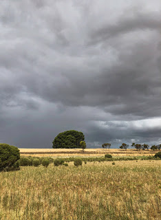
Port Fairy is situated just 290KM west of Victoria’s capital Melbourne but it could be a million miles away with its relaxed easygoing lifestyle.

The high street consists of a number of quality restaurants and shops of a standard higher than you would find in many country towns. And there is no shortage of street-front cafes when you are in need of a coffee and pastry, as we often are, such as the excellent Bank St. and Co. Cafe as well as numerous ice-cream stores for those sunny days. It was one such cafe ’Le Crepe Man of Belfast’, highly recommended by the way, that roused our curiosity and lead us to researching Port Fairy’s naming history.

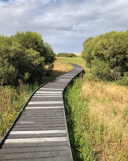
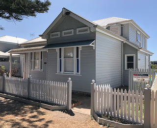
Today Port Fairy still hosts Victoria’s largest fishing fleet, but the elaborate grey and white stylish homes that now line the wharf are largely holiday rentals. It is a very pleasant place to take a stroll by the river and maybe stop for fish and chips at one of the new restaurants.

Holiday Homes a Plenty

Ready for Battle

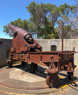
A large sandbank separates the harbour from Port Fairy Bay but a footbridge provides access to the beach and numerous properties built there to take in the ocean view. A walk along the beach is a must and you may come across the Battery gun emplacement built to defend Port Fairy from the perceived Russian threat during 1886-87.

Fortunately the guns were never fired in anger but remain to this day as a reminder of the town’s past and significance on the Victoria coastline. The rusting iron of the guns and fading paint of the signs make for great photo opportunities.

There have been changes since our last visit but we still love the place. It’s peaceful outside of the school and public holidays, it’s friendly, it’s scenic, it’s nice and warm during the summer months but perhaps just a little too cool for us during the winter. 

And the property prices certainly reflect the desirability of the town. After so many months on the road with surprisingly low house prices in rural towns, it comes as a sharp reminder just how expensive housing is in popular areas of Australia.

Port Fairy is one of those places you would be happy to visit over and over again. And we probably will.

Hello Victoria!

Leaving Mount Gambier our next stop takes us out of South Australia and into Victoria – the sixth state on our Big Lap of Australia. But first we have one more place to visit.

Portland

Portland is a small, often overlooked, coastal town, which just happens to be the birthplace of the state. On the 19th of November 1834 Edward Henty landed on the shore and established the first European colony in Victoria, a year before the founding of the state’s now capital of Melbourne. Though Henty takes the credit, a whaling station was already active here in 1829.

A regular topic of many of the places we have visited has been, by nothing but coincidence, either a World first, biggest, oldest, longest, or straightest and Portland has one or two of its own. It is the only place in the World where you can cage dive with seals. Why the cage? Just to keep the sharks out! And just outside of Portland is a simple field that was once a settlement for the Gunditjmara people dating back at least 6,600-years – older than both the Pyramids of Egypt and Stonehenge in England. Stone fish traps, still visible, are believed to be the oldest form of aquaculture system in the World.

The oldest story… ever?

And just recently the story repeated by the Gunditjmara people of the sudden arrival of giant ancestral creature transformed from a volcano with teeth of lava has gained credence according to new research. For many centuries the people have told of the land and trees dancing and an emerging hill formed from the forehead of this ancestral being with lava spat out through the earth. The volcano in question is Budj Bim, which is known to have erupted 37,000-years ago and aboriginal artefacts have been discovered buried in its volcanic ash deposits. It is thought likely the dancing land and trees represent the seismic activity that would have been present at the time. It is believed this is the oldest known story to exist.

Cape Nelson Lighthouse

Looking for somewhere to park the car and caravan we ended up at the huge car park adjacent to the Portland Visitor Information Centre and what a surprise we found there. Within the centre is a cafe that on first inspection served just cakes and snacks but a menu provided by the friendly waiter proved otherwise. An excellent selection of hot and cold meals and daily specials all cooked to order. And this is a cafe/restaurant that knows how to make a superb Thai green fish curry. Oh, and great views out over the harbour too.

Shine a light

But the real reason for our visit to Portland was to visit the Cape Nelson Light Station. The station sits 123-metres above the sea perched on the edge of the Cape’s cliffs. In addition to the Lighthouse, Keepers Quarters, workshops, and horse and cart stables and generator room (now a cafe), the site still has its original 1.75-metre wall wrapped 435-metres around the station to protect the keepers from the strong winds.

The 32-metre high bluestone tower was completed at the height of fears of a Russian invasion of the Pacific in 1884 and first lit on July the 7th of the same year. So fearful of an attack was the government of Portland that a large telescope was installed at the station to help sight any potential invaders. It came into use again during the First and Second World Wars looking for German and Japanese warships and aircraft.

The coast is littered with shipwrecks including those of ships just arriving from England having survived their arduous sea passage only to be smashed on the rocks just off the coast and within sight of Portland Harbour. The lighthouse couldn’t have come soon enough.

Telescope House

Built at an initial cost of £11,552, the lighthouse went through several upgrades and was one of the first in Australia to convert to an electric light powered by a pair of generators. Curiously the lens continued to be driven by a clockwork mechanism. It wasn’t until 1987 that mains power finally reached the station followed shortly by full automation and no longer needing lighthouse keepers.

The station is now open to the public and the Keepers Cottage is available to rent. Guided tours take visitors around the station and include a viewing from the lighthouse gantry out over the ocean and the waves crashing on the rocks below. The generator room and existing stable have now been converted to a cafe, which just happens to make some of the best scones we’ve tasted.

Sinkholes and Volcanoes

Mount Gambier

Building upon the slopes of a dormant volcano is perhaps not the first location you would choose when establishing a new city but that is exactly where Mount Gambier in South Australia began. But it is there for one very good reason.

Vital to life in this hot and dry country is fresh water and Mount Gambier has it to excess. Mount Gambier is both a town and the name of the volcano from which it takes its name. Having last erupted approximately 5,000-years ago, the Mount Gambier volcano formed above a ‘hot spot’ in the earth’s crust with magma melting its way up through the limestone bedrock of the region’s Limestone Coast.

Blue Lake – Mount Gambier

Being porous, ground water was able to seep into the volcano’s magma channels resulting in steam driven explosive eruptions, a sight that was witnessed by the local Bungandidj aboriginal mob who named the volcano, Willum-a-weenth, meaning place of fire. The Bungandidj people of post volcanic activity often referred to the volcanoes as their ‘camp ovens’, which may have indicated the ground was still hot but they were fearful of rumbling sounds that they attributed to the ‘moaning bird spirit’ and left the area.

By the time the volcanic activity had ceased an enormous cinder and ash cone with a crater measuring over 1.6KM wide and 192-meters high had formed. But the volcano has one unique feature – the base of the crater sits below the water table resulting in a near permanent supply of fresh, limestone filtered water to a depth of 70-metres and containing approximately 36,000,000,000 litres.

The Blue Lake

The resulting lake, known as Blue Lake, is one of four formed by the volcano but by far the largest and most dramatic. It takes its name from the colour of the water that undergoes a change during the warmer summer months becoming a deep sky-blue but reverting to more of a grey during winter. In reality the water itself does not change but the presence of microscopic calcite crystals react with sunlight to diffract light entering the water, much like a prism, and reflect back to the viewer just the visible shades of blue.

Blue Lake and Pump House

Below the surface large freshwater stromatolites have been growing for tens of thousands of years before being discovered by divers researching the depths of the lake. These ancient life forms, normally found in shallow waters around the planet, are believed to be the originator of most of the oxygen present in the atmosphere of the early Earth.

Far above the ground a footpath, and road, runs around the entire rim of the crater and is just as popular with locals exercising as it is for tourists taking in the view. In several places around the top of the crater the ash from the eruptions is clearly visible as are large chunks of solidified magma and limestone. Some rocks that were blasted clear of the crater weigh up to 20-tonnes.

Ash and volcanic bombs

Blue Lake is the primary source of water for the city and the very reason Mount Gambier was chosen as the early settlement. Currently 3,600 million litres of water are extracted each year and over the past 25-years the level of the lake has dropped by only 2-metres though water has been pumped from the lake since 1884. It has been calculated that the entire 36-billion litres of the lake is replaced on a cyclic basis by natural processes every 10-years.

A Sinking feeling

Mount Gambier, the city, is also home to another geologic process that has had a significant impact on the region. The limestone dissolving action of acidic water has produced many caves in the region some of which have collapsed forming large sinkholes – right in the middle of the city! Fortunately these sinkholes have been around longer than the founding of the city and are just two of a known fifty in the region…but how many more are yet to appear?

Both sinkholes became major attractions during Victorian times and, as was popular at the time, the sinkholes were ‘beautified’ with flower gardens. Both are impressive and highly unusual – especially considering their modern day location. This act of beautifying a natural feature of scientific importance would be considered gross vandalism these days and most probably illegal, but how much better is it for it? Would people still be drawn to a hole in the ground in the same numbers as present? I very much doubt it.

Cave Garden

Cave Garden

Situated just behind the City Hall, Cave Garden was once the original water source for the first settlers. During periods of rain a waterfall still forms providing a dramatic view as it descends into the remaining cave structure.

During our visit many of the flowers around the rim of the sinkhole were being removed as the spring flowers were dying back so it wasn’t at its best. From photographs that we have seen, autumn appears to be the most colourful time to visit.

A viewing platform overhanging the rim gives a good opportunity to peer down into the depths and each evening a light show projects Aboriginal Dreamtime stories on the wall of the sinkhole.

Umpherston Sinkhole

But the most spectacular is the huge Umpherston Sinkhole located opposite the Mount Gambier Visitor Information Centre. This sinkhole was made into a sunken garden by James Umpherston in 1886. A descending pathway and timber steps lead down through concealed viewpoints and among terraced gardens to reach the base where, originally, a small lake gave people the opportunity to view the gardens by row boat from a different angle. The water table has since dropped leaving the base of the sinkhole mostly dry.

Umpherston Sinkhole

Planted with hydrangeas, tree ferns and agapanthus, the walls of the sinkhole, though, are the most impressive being draped with hanging ivy. Sadly much of the grass between the terraces was well trodden despite notices to KEEP OFF THE GRASS.

As we visited the sinkhole was full of people enjoying the warm weather, which made taking a decent photograph tricky. Fortunately there was plenty of greenery to hide people behind.

During the evenings people gather to feed the resident possums that come out of hiding for an easy feed.

A tough climb

18KM south of Mount Gambier and visible from Mount Gambier’s volcanic rim is a second significant volcano named Mount Schank standing 158-metres high from base to rim. This volcano has had far less human intervention with just a very narrow and exposed path running around the rim of the cone. For those steady on their feet there is a weaving path that drops down to the centre of the volcano’s base allowing further exploration.

Mount Schank Crater

There is, however, one very noticeable work of skilled hands. Leading from just above the parking area to the top of the cone are 1,035 limestone steps. Unusual in their placement, they certainly make the very steep climb up and down the volcano safer and gives good footing to admire the impressive views across the surrounding plains. It is not a walk for the unfit or unsteady, and it is tough going, but the view from the top looking down into the crater is every bit worth the hard slog.

Make sure to take plenty of water especially if you plan to add the drop into the crater part of your experience here.

Where’s the Coffee?

As anyone following our adventure will know, we can often be found exploring the best coffee shops we can find and Mount Gambier has one of the best we have experienced since our trip began in April 2019. The Metro Bakery on Commercial Street is an interestingly quirky place with its Steampunk wall art but it serves an excellent latte and the cakes are an equal to anything you would see in the best French Patisserie. Hot meals, snacks and even a bar is provided for those of a less sugary taste. Very highly recommended!

The Vanishing lake

Situated 24KM south of Naracoorte, Bool Lagoon is a seasonal, internationally important wetland and home to a number of rare and endangered species of birds and amphibians.

Bool Lagoon

Seasonal it certainly is and best visited following the Winter rains in early Spring. When we visited in late January you could be forgiven for thinking that you were in the wrong place or someone had switched the road signs.

Not a drop of water visible anywhere and very few signs there ever had been, though the sky showed signs that rain was on the way. Instead a sea of yellow grasses, patches of paperbark trees and grass seed heads propelled by the strong wind across the road and settling in sheltered clumps like snow drifts. Even the barbed wire fences were covered with windswept grasses. Not quite what we had expected to see.
Wildlife

Following summer rains the lagoon normally fills with water attracting a wide variety of wildlife including the Southern Bell Frog – one of the largest in Australia, Brolgas, Pacific Black Duck, Great Egret, Swamp Harrier, Australian White Ibis, Straw-necked Ibis, Australian Shelduck, Black Swan, Grey Teal and the less common species such as the Black-backed Bittern, Plumed Whistling Duck, Cattle Egret, Spotted Harrier, Glossy Ibis, Sacred Kingfisher, Australian Pratincole. To date 198 individual species have been identified.

Endangered Growling Grass Frog

The Southern Bell Frog, known also as the Growling Grass Frog in South Australia, is in serious decline and considered endangered. It is already rare in New South Wales, vanished in the ACT and survives in just one population in South Australia – at Bool Lagoon.

Tea Tree Boardwalk

We braved intermittent showers and followed the raised Tea Tree Boardwalk across the wetland trying to imagine what it would be like if there was water – an impossible task. We spent more time, though, looking out for raised nails, bolts, screws and broken or missing planks on the boardwalk than at the scenery around us.

Where’s the water?

The 500-metre walk ends at a large bird hide overlooking what would normally be one of South Australia’s largest inland lagoons. A sign on the door to the hide asks visitors to ensure the door is kept closed to keep birds and bees out. Of course someone decided to ignore it and the hide is now home to several nesting Welcome Swallows.

Run down

There appears to be very little maintenance being carried out at the park, which is a noticeable theme we’re seeing across several of the South Australian National Park sites we have visited to date. It couldn’t contrast more with the excellent facilities the National Park Service in Western Australia provide. I guess the government of South Australia have different priorities and don’t have the mineral wealth of Australia’s largest state.

Naracoorte Caves

As we continue to head south towards southern Victoria, our next stop-off is the town of Naracoorte and we’re here for one specific reason – to visit the UNESCO World Heritage Listed Naracoorte Caves.

The first discovery by Europeans was Blanche Cave in 1845, located in what is now the Naracoorte Caves National Park, but it is just one of 28 caves so far discovered. At present only four caves: Alexandra, Blanche, Stick-Tomato and Victoria Fossil Cave, are currently open to the public with most of the remainder reserved for scientific research and requiring greater protection. A few further caves are accessible but only through Naracoortes Adventure Cave Tours.

Limestone Coast

Naracoorte sits upon massive limestone deposits left exposed by the rise and fall of sea levels 200-million and 20-million years ago. The caves complex formed from fracturing of the Kanawinka Fault allowing water to enter via cracks and fissures. Over time rain and ground water leaching through surface vegetation created a weak acid, which, to this day, continues to dissolve the limestone beneath. In places the subterranean cave ceilings have collapsed creating sinkholes and traps for unsuspecting wildlife to fall into but often also forming ideal habitats for bats.

Marsupial Lion

The Naracoorte Caves, believed to have formed some 500,000-years ago, are particularly known for what fell into them over a period of hundreds of thousands of years. Soil and sediment that has built-up on the cave floor, 20-metres deep in places, has created a layered history of the species of plant and animal that existed at that time including creatures that are unique to Australia, creatures such as the giant short-faced kangaroo and marsupial lion – the so called Megafauna. Of international significance is Victoria Fossil Cave, which is rated among the ten most important fossil sites in the world.

Alexandra Cave

Discovered by William Reddan in June 1908 and named after Queen Alexandra, wife of King Edward VII. When first explored Alexandra Cave was largely filled with soil and silt, which had fallen or been washed into the cave over a period in excess of 100,000-years. The infill was painstakingly removed by hand to reveal some spectacular caverns, stalactites, stalagmites and helictites.

Just a year after discovery the cave was officially opened to the public with 2,000 people in attendance. Reddan, acting as caretaker of the cave, led the official party through the cave using the brilliant light of magnesium lamps. It is not known how much scientific discovery was lost as the cave was excavated but more recent core samples taken in the remaining sediment have unearthed over 100,000-years of evidence of life in the past including plant, pollen, insects and mammal bones. The search into the past continues in other caves in Naracoorte Caves National Park.

Alexandra Cave
Stalactites & Stalagmites

A regular tour schedule is available during school holidays with a 30-minute guided tour dropping up to 30-metres and 240-metres along the cave where the noticeably humid air remains at a constant 17C year round. Twenty-five steps lead down to the mostly level cave floor that is largely compressed soil with up to 9-metres of sediment still remaining.

Stone Straws

We’ve been spoilt by some of the spectacular caves we have visited in Western Australia and it is hard for Alexandra Cave to compare. That’s not to say it isn’t impressive – far from it, it has some stunning examples of straw stalactites growing just 1mm per year on average making the longest examples many thousands of years old.

Stone Straws

Each straw is formed by calcium-rich water dripping through the centre rather than along the sides of a stalactite. The straws are extremely delicate and hard to believe they are so old and have survived for so long. It would take just one wayward bat or an inquisitive child to destroy them. It is for that reason everyone is constantly reminded not to touch any of the decorations throughout the duration of the tour.

Mirror Mirror

One feature, and one of the highlights, is the mirror reflection in a small pool of water in the main chamber. The complete absence of drafts or vibration gives a perfect reflection of the stalactites hanging from the roof of the cave. You have to look twice to figure which is the reflection and which the real stalactites. However, impressive though it is, it is a man made feature created shortly after the cave was opened to the public.

Flow Stone

Above ground is a 900-metre walk that, in places, follows the path of the below ground caves as well as passing several other show cave entrances such as the large Blanche Cave and the protected Bat Cave. And giving an idea of the many extinct megafauna that used to roam around this area are steel sculptures in the shape of each creature with the fossil bone structure shown in relief. It’s a clever idea and fun for children (okay, some adults too) to spot as they wander along the pathway.

Victoria Fossil Cave

Given time a visit to Victoria Fossil Cave is recommended to view many of the reconstructed skeletons of creatures that entered the cave but never found a way out. With hindsight we should have visited this cave too if we had known more about it. The available literature at the Visitor Information Centres and online is poor in explaining what there is to see and, unusually, very few photographs too. I guess they don’t want to give too much away.

Ancient Creatures

Entry to each cave is charged on an individual basis but a discount is offered if you want to visit more than one cave on a single day. And for those a little more adventurous there is an option for an Adventure Cave Tour to get down on your hands and knees and crawl. Overalls and safety gear are provided. Bookings are essential.

Somewhere to stay?

You could easily spend a couple of days exploring the Naracoorte Caves National Park and a campground is provided for those wishing to stay close by.

The town of Naracoorte lays just 28KM to the north and provides a number of popular camping and caravan sites including the conveniently located campsite at Naracoorte Showground where we stayed.