Located 16KM south of the coastal town of Cervantes in Western Australia is a remarkable and immense outcrop of stone pillars known as The Pinnacles. Just as remarkable, though, no one is quite sure how they formed.
The Pinnacles
Set within Nambung National Park, the Pinnacles Desert looks like a scene from an other-worldly Science Fiction film. Thousands of limestone pillars upto 5-metres tall stand among compacted yellow sand. Unusually for a National Park intent on preserving its heritage, this is one location you can both drive around and walk freely. There are even regular parking bays, which is a first on our trip.
Pinnacles Drive
More suited to a high-clearance 4WD vehicle than a standard car, the Pinnacles Drive leads in a winding loop around the limestone pillars, which extend over a large area of ancient sand dunes. The track is clearly marked by regularly spaced boulders and occasionally pinnacles, which provide little clearance for wider vehicles or less capable drivers as tyre marks and paint scrapes attest.
Right at home among the sand and Pinnacles
Windswept Origins
The strong winds on the West coast had initially eased a little on our visit but it was clear to see areas where the wind sweeps through the park gradually eroding the pillars into some unusual shapes. The wind is also slowly exposing further pinnacles in a cycle that has repeated many times as sand blows inland from the nearby beach. In fact the formation of the Pinnacles is closely tied to the winds common to the Western Australia coast.
Planet Earth?
During a period of abundant marine life, shells rich in lime deposited on the beach gradually broke down into fine-grained sand and subsequently blown inland forming dunes. At this point three possible theories are trying to explain how the pinnacles formed. The most probable at the moment, at least until further studies prove otherwise, suggests rain falling on the dunes leached calcium through the upper layers of sand creating a soft limestone below that, through time and with successive deposits of sand, compacted and hardened.
Subsequent periods of environmental change created soils that covered the dunes allowing plant life to flourish. The plant’s roots burrowed down into the limestone seeking moisture and creating cracks in the process. During much drier periods the wind stripped the topsoil and loose sand exposing the limestone below to the weathering effects of the seasonal winds and further eroding the cracks creating isolated pillars. The whole process taking somewhere around 80,000-years to create what we see today. Though come back a few years later and it may well have changed again with new pillars exposed and some buried under the shifting sands.
Ancient City?
Well at least that is the scientific take on the origin of the Pinnacles. Early mariners viewing from the sea believed the pinnacles were the ruins of some ancient civilisation but it wasn’t until the 1950’s that the area was truly explored. Realising the geological importance of the region the Pinnacles Desert was placed under protection with the creation of the Nambung National Park.
The Pinnacles is yet another of those photographer’s paradise locations in Western Australia and a must see on a west coast trip. The close-by beachside town of Cervantes provides camping facilities as well as motel rooms, a supermarket, newsagent, fuel and the famous Lobster Shack providing delicious seafood meals.
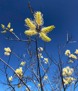
We timed the start of our trip around Australia to catch the Western Australia wildflower season as it progressed down the west coast from the Pilbara region in the north to Albany 2,300KM to the south. Low rainfall, unfortunately, has lead to a shorter, less colourful season this year.
Coppercups
Change of Plan
Small town Visitor Centres are great places to identify the best locations and current state of the wild flowers in their region. And it was based on the knowledge at the Geraldton Visitor Centre that we changed our plans. Rather than follow the popular routes where most of the flowering was over or beyond its best, we took a wider loop through the Mid-West Wheatbelt where the roadside bush was coming into bloom.
Orange Immortelle
Heading from our recent stay at the coastal town of Geraldton out towards the country town of Mullewa and we were soon into wheat country. We were taking the so called ‘Everlasting Trail’ named after the paper daises that normally spread along the roadside.
A few small patches were still visible but mostly faded and withering. We were, however, greeted with many later flowering plants and shrubs ranging in colour from white through to yellow, blue and purple. But it was the cultivated fields that dominated.
Paper Daisies
Mid-West Wheatbelt
The Wheatbelt extends over 160,000 square kilometres and covers every metre of available space divided only by roads and narrow lines of trees. A few patches of scrub and woodland still stand showing how the region once looked before early settlers began clearing land for agricultural use.
Very noticeable are large, low-laying areas of salt where the salinity of the soil has risen as a result of change of land use through the introduction of annual, shallow rooted crops and increasingly low rainfall. The lack of rain has allowed the subsurface salt-laden water to propagate up to the surface where it quickly evaporates leaving the salt behind. Some blame climate change but most understand human activity – altering the biodiversity of ancient land – is the cause.
Barley in the Wheatbelt
As has happened so many times on our trip, trying to take a photograph from the roadside is near impossible with no way to pull-over safely – especially with a caravan in tow. So, much to our surprise, we came across a huge lay-by, recently constructed, right next to several fields so I could take a photograph of a wheat field. And what did I find? Nothing but barley in all directions!!
Wattles
Between fields of wheat and barley the roadside is populated by a multitude of shrubs, bushes and Banksia trees. Many of the bushes and smaller trees are members of the Wattle family, which produce prodigious blooms of yellow/gold flowers throughout several seasons of the year. The wattle is a source of food for the Aboriginal people of Australia and increasingly adding to the kitchen of the western diet. The seeds from the wattle can be crushed to produce flour or added to cakes to impart a coffee flavour.
The yellow/gold flower and green leaf of the Wattle may be less known for something every Australian is familiar with – the national colours of Australia and the colours of the national sporting teams since being first introduced in England at the opening match of the 1899 Ashes series. Australia won by the way.
Enough with the Flies
Australia is well known for its flies but again this is partly due to human activity. Around the Wheatbelt region the flies are by far the worst we’ve experienced and the most persistent too. Even the strong wind doesn’t seem to deter them from creating as much annoyance as possible. And the reason for the flies? In a word – farming.
Yellow Leschenaultia
These insidious creatures go by the name of Musca vetustissima or more commonly the Australian Bush Fly. They lay their eggs in cattle dung and a single cow pat can produce 3,000 flies in just two-weeks. The average cow drops 10 to 12 pats each day and with in excess of 28-million cattle in the country it’s clear to see there is a fly problem – potentially 220-trillion irritating insects every year.
Things are so bad that efforts are underway to introduce dung beatles from Europe that quickly bury the cow pats returning nutrients back into the soil and capturing carbon in the process. Let’s hope, though, we don’t end up with another introduced species disaster like the Cane toad… or the Rabbit… or the Fox…
Dampiera
What plant is that?
So, our adventure inland didn’t produce the wide range of wild flowers we had been hoping for but we did at least see a few new species. All we have to do now is to try and identify them and as there are 12,000 species in Western Australia, 60% of which are unique in the world, it may take a while!
If you should find yourself one day driving south along George Gray Drive coastal road towards Northampton in Western Australia, you could be forgiven for thinking you have caught a flash of pink in the corner of your eye, a flock of Flamingos feeding in a lagoon perhaps. Well you wouldn’t be too far off the mark as I’ll attempt to explain.
Pink Lake Lookout
Hutt Lagoon, next to the small township of Gregory, is a salt lake created by a sand dune barrier separating the lagoon from the sea water of the Indian Ocean. Laying just below sea level, gravity allows sea water to seep into the lagoon where evaporation is the only way out and in the process leaving behind significant salt deposits. Rain water during the wet season helps keeps the salinity level in check.
Dunaliella Salina
The colour of the lagoon comes from a microscopic form of green algae known as Dunaliella salina, which has the ability to create high levels of beta carotene – a common and natural red food colouring, an antioxidant and source of vitamin A.
No Flamingos here
It is believed the colour helps protect the algae from the extreme ultra-violet radiation that is typical of the areas that the algae thrives. The quantity of beta carotene is at its highest during the spring and summer months when the UV radiation is at its most elevated causing the lagoon to take on a pink or reddish hue.
Hutt Lagoon supports commercial operations including the world’s largest microalgae production plant using artificial ponds to grow the algae for the food and cosmetics industry and Brine Shrimp farming for the fish, prawn and aquarium trade. Still want to use that red lipstick?
And the flamingos?
Beta carotene is the colour creating agent found naturally in crustacean, which includes shrimp and prawn – among the flamingos natural diet. It is added to food pellets given to captive flamingos in zoos around much of the world. It is also the reason the shell of crustacean turn red when cooked.
Salt encrusted rocks
Depending on the time of day the best photographic point is either at the Pink Lake Lookout on the road to Gregory, or from the top of the hill just beyond the lookout. Just a few hundred metres further on and looking northwards, the lagoon is more easily accessible along a short path leading to the water’s edge where rocks in the shallow water are heavily encrusted with salt.
Hutt Lagoon creates an amazing spectacle for landscape photography and well worth a detour from the North West Coastal Highway.
Photo Tip:
Use of a circular polarising filter is recommended to reduce reflections on the lagoon. It also helps saturate the colour of the pink water and blue sky to more accurately capture what the eye sees.
Situated on the Indian Ocean coast 485KM north of Perth, Kalbarri National Park is a diverse arid region with magnificent ocean cliffs, inland gorges and the Murchison River that flows into the sea at the small seaside town of Kalbarri.
Driving south on the Northwest Coastal Highway from our last camp at Denham delivered an unexpected surprise. Mulga scrub and acacia spread out over flat sandy plains with spring flowers lining the roadside gradually gives way to larger shrubs, and Spotted River Gums. The surrounding landscape starts to undulate with winding roads and then, all of a sudden, cresting a hill, there is a total and unexpected change of scenery. Gone are the Mulga plains and dense bush, the wild flowers and trees. We have suddenly arrived in the rolling hills of the Wheatbelt. It’s almost like a summer scene in England with golden fields ready for harvesting. Quite surreal.
White Plume Grevillia – Smelly Socks
Smelly Socks
Just as suddenly had we arrived among the fields a turn to the left took us back into the sand plains and on to Kalbarri National Park. Along much of the road wildflowers were in bloom and one in particular stood head and shoulders, literally, above the others.
Among the last in the season to flower, the White Plume Grevillia has pale cream flowers on the ends of long stalks growing from the lower grevillia shrub. A sickly sweet scent is released at dusk and in the evening to attract insects. Its common name very aptly describes its appearance and odour – ‘smelly socks’.
Our first visit into the park took us through classic Mulga territory with the occasional Grass trees and Sandplain Cypress trees standing above the acacias. Wild flowers are again dotted along the side of the road in clumps of yellow, white, orange, red and blue. It is towards the end of the wildflower season now but nature is still putting on a show.
Coppercups
Nature’s Window
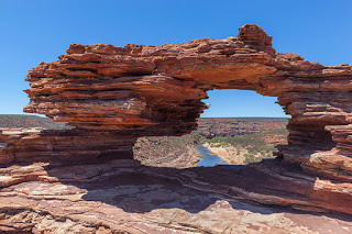
We had planned several walks in the park and our initial destination was a rock formation known as Nature’s Window, which stands on top of a gorge wall overlooking a large bend in the partially dry Murchison River 100-metres below. From the car park a set of steps lead down to a tarmac path where you’re likely to be greeted by extremely irritating flies. It’s for good reason many people walking this trail are wearing fly nets, something we should have thought about and will keep with us in future.
Nature’s Window
The trail leads downhill through Mulga shrubs to a small lookout and rest stop with views down into the gorge and along the river. A short stroll further on and the trail becomes a scramble over striped rocky ledges formed from ancient sea floor sediments with ripples still clearly visible in many places. There are a few exposed locations with drops into the gorge that are best avoided, for obvious reasons, and a small stepped rock climb upwards and you find yourself standing right by Nature’s Window.
Weathering of the soft sandstone has created a framed rock hole with views down to the river and along the gorge. Looking quite delicate in places, it has been advised that taking a selfie within the frame is not recommended practice but people still do. And they’re most likely of the thong wearing brigade.
A loop walk continues along the edge of the gorge for 8KM but the flies were too persistent for us to carry on any further.
Kalbarri Skywalk
High up to the left overhanging the gorge are two prominences – both man made. When complete they will form cantilevered lookouts 100-metres above the river. The project, known as the Kalbarri Skywalk, was due for completion in mid-2019 but now in mid-October the $20-million project is clearly way behind and looks unlikely to open before the end of summer 2020.
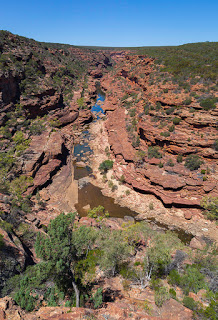
Z-Bend Lookout
Z-Bend Lookout
Our second walk, 11KM to the south, took us to the Z-Bend Lookout. A well maintained gravel track leads through the bush to a view into the gorge along a natural fault line that is responsible for the z-shaped path the Murchison River takes here.
The rock fractures caused by the fault have created an easy straight path for water to flow and erode rather than the smooth rounded bends more normally associated with rivers cut through valleys and gorges. The result is the angled changes of direction of the river and in this case taking the shape of the letter ‘Z’.
For those wanting more of a challenge, and ideally with an accompanying fly net, a nearby track leads down into the gorge and along the 6KM path known as the Four-Ways Trail.
Scorpions
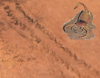
Just before the lookout a display board shows a large, life-sized image of an ancient sea scorpion, a creature you wouldn’t want to step on while walking in the shallows. Beside the sign is a number of fossilised trackways created by this hand-sized crustacean and frozen in time nearly 400-million years ago.
Sea Scorpion tracks
It is believed this creature was one of the very first to transition from the sea to land at a time when plants and grasses were still to appear.
Enough with the FLIES
Having had enough of the flies we decided to head to the coast, still within Kalbarri National Park. Nine sealed roads lead to a number of easily accessible lookouts over the blustery Indian Ocean.
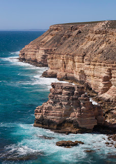
We started with a trip to Island Rock 16KM south of Kalbarri town, which leads to amazing views of the ocean but it is only after leaving the car and taking a short stroll along the sealed path that you get a full view of the magnificent, almost white, sandstone cliffs. These are the most dramatic cliffs we have seen in the six-months of our travels through four-States. Easily the most arresting sight so far and looking very similar to many of the rugged coastlines of the UK.
Island Rock
Island Rock
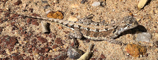
As its name suggests Island Rock was once part of the Tumblagood sandstone cliffs but erosion by wind and waves has undercut the rock finally isolating it to form a sea stack. While walking further along the path towards the next viewpoint I spotted a tiny dragon and managed to snap a few photographs before it dived for cover. It was a new one to us – a Mallee Military Dragon and just 6-centimetres long. Natural Bridge
The strong wind whipping-up the sea and smashing wave after wave against the rocks makes this site all the more impressive. None more so than at Natural Bridge where the waves have eaten away at the cliff leaving a harder section of rock protruding into the sea. Over time, continuing erosion has removed rock along the base until collapsing layers have left a bridge linking the rock to the cliff. Eventually, though, the span of the bridge will collapse leaving a second Island Rock.
Mallee Military Dragon
Snake!!
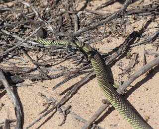
While taking photos of the the scenery I turned and noticed a sizeable and highly patterned snake cross the path into the scrub. Catherine went to take a closer look as I swapped lenses and followed. The snake was partially among the branches of a low-laying acacia but I managed to fire off a shot before it took cover further away. A beautiful looking creature but it wasn’t until the evening before we identified it – a Mulga snake, also known as a King Brown and highly dangerous.
Natural Arch
Unlike the Brown snake the King Brown isn’t aggressive but it will defend itself when cornered. Its venom isn’t as toxic either but it is the quantity, 10-times that of the Brown snake, that does the serious damage. And neither does it give a quick bite and run instead hanging on with a chewing action to ensure the recipient receives the maximum dose.
Despite its name the King Brown is not related to the Brown snake at all, it belongs instead to the Black snake family. It has a venom of unusual qualities that is being extensively researched. Rather than aggressively attack the nervous system or the heart, the King Brown’s venom principally targets striated muscle tissue, those in the legs of most walking creatures and preventing its prey from running away. It also, like many snake venoms, causes blood cells to rupture. A second novelty are two antibacterial agents that are active against the bacteria found in its most common form of prey – amphibians and reptiles. Not only does it keep its incapacitated prey alive it is also able to protect itself from bacterial infection. Now that’s a clever bit of evolution.
Mulga (King Brown) Snake
Recent research into the snake venom’s antibacterial properties has shown one isolated antibacterial agent is seventy times more effective than current drugs and it is hoped this could lead to a solution for the increasingly drug resistant strains of bacteria, the so called Super Bugs.
It’s quite ironic that a creature that strikes abject fear into so many people could one day help save their lives.
Kalbarri, the National Park and the ‘must see’ spectacular coastline have been quite a surprise. Add to that the unexpected wildlife and the wild flowers that we thought we had missed being this late in the season. We still have one more walk to do later in the week and I suspect that will throw yet more surprises. We’ll also be taking our fly nets along!
Fragum erugatum, well known to those with an interest in marine life, is the reason for our visit to a spectacular location this morning. Situated on Shark Bay Road 44KM southeast of Denham is Shell Beach – all 66KM of it.
Cockles
For thousands of years the Fragum cockle has been the exclusive shellfish in this area of the L’haridon Bight. With no predators, hypersaline water and no competing species the Fragum cockle has proliferated and the result is a beach made of tiny shells, trillions of them – in places to a depth of 10-metres. It is one of only two beaches in the world made entirely of shells.
Shell Beach – Shark Bay
Blindingly bright and looking more like snow, it requires a closer look to see that these really are shells.
Growing to a maximum size of 14mm the cockles bury themselves in the seabed with over 4000 sharing the same square metre before ultimately washing up on the shore.
Coquina
Until Shell Beach became World Heritage Listed it was briefly quarried to produce ‘stone’ blocks.
After being washed ashore for more than 4,000-years, the deeper layers of shell become highly compressed. Rain, absorbing carbon dioxide from the atmosphere, creates a weak acid, which leaches through the layers of shells producing calcium carbonate and cementing the compacted shells into a stone known as Coquina.
The stone was hand cut into large blocks and used for building material. A good example of Coquina stone construction is the Old Pearler Restaurant in Denham.
The remains of the quarry still stand and are clearly visible from the beach but are now restricted access though some stones are still being cut but only for repairing existing Coquina stone buildings.
Take a dip
The water in the bay has twice the salinity of normal sea water, which makes it very easy to float in but your skin will get a generous crispy coating of salt in the process.