Katherine Gorge – Nabilil Dreaming

From a photographer’s perspective there are four times at which it is best to see Katherine Gorge; sunrise and sunset during the ‘Wet’ and sunrise and sunset during the dry season. The ‘Golden Hour’, an hour after sunrise and an hour before sunset, produces the best light for landscape photography. In the case of Katherine Gorge the golden hour light transforms the near vertical canyon walls into glowing orange, reds and yellows against a deepening blue sky. And so it is no surprise that we have chosen an evening dinner cruise on the Katherine River through the Gorge.

Nabilil Cruise – Katherine River

We joined the rest of our cruise companions just beyond the Visitor Centre where we chose our dinner option and then were guided to our boat and our indigenous captain and guide, Jimmy. Immediately opposite the jetty was a crocodile trap, a good sign that saltwater crocodiles were known to call this river home. Crocodile safety was a feature of Jimmy’s introduction and dangling limbs in the river was not advisable.

Within a few minutes of casting off we got our first sighting of a freshwater crocodile as it lazed in the lowering sun. The ‘freshies’ are more colourful than their saltwater cousins with bright yellow/green and dark stripes. They somehow look less prehistoric too with their long, narrow jaws and are certainly less aggressive. Jimmy took the boat closer to the river bank to give everyone a closer look before it decided we looked more like prey and sunk beneath the ripples our boat was creating.

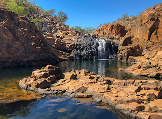
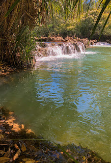
The first section of our tour is actually along part of a series of 13-pools created along the length of the gorge. Dam walls in the underlying riverbed are normally under several metres of water during the wet season but as the dry season takes over the river level drops leaving pools with some low level waterfalls for what flow remains. It is for this reason that the National Park Service are confident they can keep the pools free of saltwater crocodiles – once the pools are isolated the crocodiles can no longer move freely and are more easily trapped.

Dreamtime Creation

Jimmy explained the Aboriginal story behind the creation of Katherine Gorge and this pool in particular, which was named after the sound of the Cicada as Nitmiluk – Nit, Nit being the sound and Luk meaning the place of.

We were just approaching the end of the first pool and a large rock wall blocking the flow of the river. At this point a 400-metre walk takes us past 20,000-year old rock paintings and a great location for photographs of the gorge walls reflected in the water. And at the end of the walk is our second boat ready to take us further up the river.

Pool Two

Now the more observant may be starting to wonder how a large boat got to the second pool when it is isolated by the dam, surrounded by the huge walls of the gorge and no access by road. As Jimmy explained, it was a common question, and it relied on the high water level during the Wet. Each season a high powered boat tows the cruise boats against the current to their required location where they are lashed to the gorge wall in a way that later keeps them secure as the river level drops and the pools reform. At the start of the wet season they are returned on the rising river for safe storage and readied for the next year.

Sun setting over Pool Two

The second pool is also the location for canoe adventures, which are able to navigate further up the gorge. I’m not sure I would want to be part of the first trip of the season – have every one the saltwater crocodiles been found and removed?

By now the sun was starting to set and the gorge walls were beginning to glow in the light. The orange colour of the gorge is caused by rusting of the iron oxide contained in the sandstone. Below the surface, free of oxygen, the rock remains white.

As we cruised further upstream Jimmy explained the scientific version of the gorge’s formation. In the same way that the sandstone we saw at Edith Falls was created, the sandstone in the gorge is also fracturing into regular rectangular blocks. Over time the blocks break away and fall into the gorge to be ground down by the river. Unusual here, though, for a river path, there are none of the classic curves and bends, instead the river takes 90-degree turns along the fracture lines of the rock. 

After a few last sunset photos it was time for dinner and our final boat was waiting for us. This one had tables laid out with white tablecloths, native flowers and candles. As we set-off we were presented with a glass of sparkling wine with a red hibiscus bud and introduced ourselves to our table guests. An entree of smoked chicken, crocodile, kangaroo tail and salad was followed by Barramundi or eye fillet, a mango sorbet and flourless chocolate cake with a berry coulis.

Drifting along after sunset

As the stars began to appear we drifted quietly around positioning the boat for the best views with spotlights lighting the riverbanks while catfish swam all around us. It was such a peaceful, relaxing highlight to the end of an excellent cruise with good company and great food. Very much recommend. You can find out more about the Nabilil Dreaming Sunset Dinner Tour at Nitmiluk.

The drive back to the campsite was in darkness and staying well below the speed limit knowing kangaroos were likely to be around. And true to form our headlights caught a small grey roo right beside the road. Fortunately it chose to move back into the bush rather than run across the road in front of us.

Katherine – Edith Falls

42KM North of the town of Katherine in the Northern Territory sits Nitmiluk National Park, named after the aboriginal ‘Place of the Cicadas’, and home to Katherine Gorge and Edith Falls.

We’re visiting Edith Falls today, known more recently by its aboriginal name of Leliyn, which comprises several waterfalls between three pools of clear crocodile free water. Now I should clarify here for the less cautious, if you read the warnings about crocodiles in this area you may be forgiven for thinking there are no crocodiles, Salties or otherwise. Read the warnings carefully though and you may think again about plunging into that tempting creek or billabong. The information display near Edith Falls kiosk clearly states that a management plan regularly surveys the area, sets traps and removes any saltwater crocodiles found. It does not say there are no crocodiles. Still thinking it’s safe to swim?

Leliyn Trail

The trail then levels out through a mixture of scrub and Kapok trees before climbing again to the high point offering our first view of the top waterfall. It’s an impressive sight even during the dry season and we can only imagine what it would be like in the ‘Wet’.

First View

Our walk to the upper falls follows the Leliyn Trail, which starts from the car park and heads steeply uphill for 500-metres giving the first view of the lower pool. As usual, any photographer will be competing with the abundant trees and shrubs to get a good view despite the recent bush fire.

Thongs in the bush – seriously?

A brief stop for lunch and we were soon being passed by some very young children clambering over the rocks and boulders that lead down to the falls, and where were their supervising parents? This section of the trail is not for those without experience of scrambling, fear of heights or generally unsteady in their gait. There are sharp rocks, gravel paths, slippery surfaces and highly venomous snakes in this area, yet people seem to believe thongs and not enclosed walking shoes are appropriate despite all the warnings at the start of each trail. Still, I guess natural selection will weed these people out over time.

Edith Falls – Upper Pool

Swimming Hole

Being from the UK, where the weather isn’t always conducive to swimming in rivers, or safe for that matter, I still find it hard to understand why people are allowed to swim within National Parks. Why?

Well, with such a pristine an environment as this and the conservation efforts that help keep it that way, humans carry germs and viruses on their skin and that’s not to mention the young ones in the water today in nappies. Not only that but as many a landscape photographer will tell you, scenery is for looking at and not for clambering over and dropping litter.

Mid-Pool

A case in point of the need to conserve this area lays with some of the flora found here and only in one other place – Southwest Australia.

The upper pool waterfall is a thing of beauty even during the dry season as we visited but it’s also full of people swimming in and around it. If ever there was a need for Photoshop this was it. And fellow photographers will know exactly what I mean.

Two further footbridges lead over the river to the opposite bank where a steep scramble leads to a viewpoint looking downstream to the second pool. You’ll hear the sound of a waterfall but it is obscured by rocks. Continuing a little further and the walk levels out with a second viewpoint signed Bemang Lookout at a junction in the path. We heartedly recommend this 40-metre detour for the view upstream and of the waterfall, obscured at the last viewpoint, but which also takes in the top waterfall and pools where we earlier crossed the river.

Tawny Bladderwort

The remainder of the walk starts a gradual decent with views across to the distant hills. Finally dropping down into the valley and alongside the first waterfall and pool, which we had barely seen through the trees when we first started the walk. Here easy access to the water is provided with canoes available to rent and a campsite and cafe. It was while we were here waiting for an ice cream that I noticed something moving among leaves near the path. Our first snake and a venomous one too! It was a black whip snake about 1.5-metres long and searching for food oblivious to us standing nearby taking photographs. It eventually moved across right where I had been sitting and off towards the campsite to spread a little excitement.

Black Whip snake

A local aboriginal man spoke about the snake and advised lookers on that it was safe and not aggressive but a bite would be potentially fatal for a young child or aged adult likening it’s bite to that of pouring battery acid onto an open wound. A couple who had just completed the same walk as us had earlier seen what appeared to be a king brown snake with its coppery coloured scales.

A Balancing Act

On the way into the National Park we noticed several large boulders balancing on top of each other. These were very similar to the balancing rocks at The Devils Marbles, also known as Karlu Karlu, that we had planned to see but which would have been a long diversion on our route. We were also earlier advised that it was very busy there and difficult getting a space to camp overnight. So, on the return leg, leaving Nitmiluk, we pulled over to photograph the stones and we appeared to be the only ones taking any notice of them.

Balancing Rocks

Much of this region is composed of sandstone but of a type unlike any I had seen before. Most sandstone is grainy and breaks apart easily. Here the layers of sand from a former inland sea have been compressed to such an extent over millions of years that the grains have fused into an extremely hard, glossy rock. The crystal structure that has resulted leads the rock to weather into square blocks and eons of rain and wind eventually round-off the corners leaving almost circular ‘balls’ left balancing on top of each other. The precariously placed rock in this case was over two metres wide.

Now, if you were to stand here long enough, and it will likely take quite a while – be patient, you may witness the rock finally topple to the ground to become just another boulder scattered across the bush. And then all the magic over millions of years that produced this balancing act will have been lost for all time.

So, pull-over, stop, admire and take a photograph before it’s too late. You may even be the person that photographs the rock as it teeters and falls. Or, less fortunately, the one standing a little too close for a selfie, the one wearing thongs.

Mataranka

At last, we’re staying at one location for more than an overnight stop. We have arrived at Mataranka, a small township on the edge of Elsey National Park.

Our camp for the next four nights is the Little Roper Stock Camp, a rustic, dusty campsite but with plenty of shade from the heat of the sun. It’s a friendly place with an evening campfire and fresh bread baked daily to order by Des. There’s nothing like a fresh, crispy loaf and the smell of baked bread in your caravan in the morning… other than a freshly brewed coffee of course!

Johnny Cakes are also available at 8am by the campfire. These date back to the 16th century in the UK but also popular as Journey Cakes during the American Civil War. They are simply flour, salt and water mixed and formed into a pancake shape and cooked in shallow oil.

Bush Walks

We’re here to do some bush walking and also for a dip in the hot springs, which this National Park is known for.

Botanic Walk

Our first short stroll was around the Botanic Walk, which starts from the roadside carpark and forms a 1.5KM loop. Many of the trees and shrubs are identified with their scientific name as well as the aboriginal name and what they used them for. Leaves crushed to make soap, lemon scented leaves for cooking with fish, sandpaper leaves for smoothing spears and tree trunks carved with stone tools to create canoes. Also many paperbark trees whose bark peeled, dampened and used to wrap fish before placing them over hot ashes. Trees even used to identify the time of year – in this case flowers bloom just as crocodiles begin to lay their eggs, a local delicacy.

Be Croc Wise

Our second walk for today, at 4-Mile, leads along a gravel track to the river and a boat ramp. This was our first view of the Roper River. Now around here you may be tempted to jump in to cool-off on a hot day. The water is certainly inviting, fresh and cool with some beautiful trees lining the river banks. There are, however, a few hazardous things in the river  – submerged trees for one and one or two crocodiles – both Freshwater and Salties. The freshwater crocodiles keep to themselves but the saltwater variety, well, best to leave them well alone. As such, swimming and canoeing are no longer allowed in the rivers. Needless to say we didn’t get too close to the water – we still have many places to visit on our trip where limbs are quite useful.

Mataranka  Falls

Termite Mounds

The following day we set-off for a longer walk, which forms part of the 16KM trek alongside the Roper River. Starting at 12-Mile Yards, an old cattle stock pen, our walk started off badly through what can only be described as sand. The track is bone dry and comprises a mix of gravel, very soft sand, dust and a few patches of rocky outcrop. It’s hard going where the sand has settled into long hollows but eases further into the walk. A few glimpses of the river between cabbage palms eventually brings you to an opening with a good view along the river, which has formed along a natural fault line between limestone and the deep red sandstone.

Each kilometre is a marker and well signed way-posts help keep you on the right track. Both sides of the pathway have many trees and shrubs providing some shade but the most striking thing is the number of large termite mounds, some reaching up to two metres high. These industrious creatures are vital in this environment. The termites eat grasses and hollow out trees as well as lifting many types of mineral to the surface. Once the colony dies the minerals are slowly released as a fertiliser preventing the ground from being leached each year during the wet season. The termites are also a source of food for birds, reptiles and frogs. The hollowed out trees serve as nests for parrots and provide the base material for the aboriginal didgeridoo. Not quite as destructive as we are led to believe.

Wild Cotton

Every so often I noticed what appeared to be clumps of white fluff along the path. We soon found the source – several wild cotton plants. We have seen some cotton plants growing in Queensland but this was the first in the wild.

After a few creek crossings where aluminium bridges had been placed, the path opened out into a sparsely vegetated rocky outcrop in the full heat of the sun. But eventually, after scrambling over limestone rocks and tree roots we could hear the waterfalls but we couldn’t see them.

Mataranka Falls

We weren’t expecting too much having seen photographs previously but we were left wondering where the photos had been taken from. All along the riverbank, where the falls were, trees and long grasses obscured the view. Only a few spots gave a glimpse and each of these were right by the water in low lying areas – ideal for crocodile access.

For the moment we carried on to a small campsite for lunch where we met a lovely lady from Tasmania. She had already tried to find a better viewpoint from the high ground and saved us the effort.

On our return leg I built up the courage to get closer to the water and quickly took a few photographs while keeping a close eye on anything that may be hungry. It was now hotter even hotter and our return trek on the 8.4KM walk was interrupted only by a few shady spots and a drink of water. I would hate to think how hot and humid it would be here during the summer. And how wet too, much of the area shows signs of flood where the wildlife is more likely to wander further afield. A great walk but there is better to come.

Bitter Springs

Mataranka is rightly famous for its thermal springs. Water filtered by the limestone hills of the Barkly Tablelands and bedrock works its way to the surface carrying with it heat and a rich supply of minerals, especially calcium. Mataranka has two popular springs, one at Mataranka Homestead and the other, far more natural and our choice, at Bitter Springs just a few kilometres from our campsite.

Bitter Springs

The water is a very pleasant 33C, extremely clear and free flowing. From a carpark a short concrete path leads to the start of the defined swimming area. From here a ladder drops you into the spring and you simply relax and let the slow current take you along several hundred metres of beautiful forest to a ladder and bridge, which marks the return path to the start. Although busy on our visit, the current keeps people moving along so it doesn’t become crowded. Sadly I appear to have started with a chest infection so only Catherine got to enjoy a swim.

Today marks our third month on the road and it’s hard to imagine returning to a more normal life in suburbia with traffic and road noise.

Tomorrow we set-off again a little further north and another Northern Territory adventure, this time in Katherine.