Lake Argyle

Three times the size of the UK and with a population less than 40,000, the Kimberley in Western Australia is one of the oldest regions on earth.

Sunset from Lake Argyle Resort

We’re staying at the edge of Lake Argyle, an enormous man-made reservoir, in the northeast of the Kimberley.

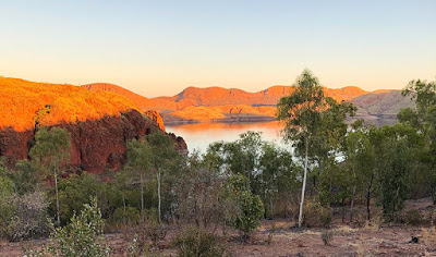
The Lake Argyle Resort sits just above the lake giving views across the water to many of the lake’s islands, bluffs and sandstone hills, which light up at sunset and sunrise. Just how many campsites can provide a view like this in such an unspoilt and remote location?

There are plenty of things to do here for the adventurous and those who prefer to relax by the infinity pool soaking up the sun. Walking trails, 4WD-adventures, helicopter flights, boating, fishing…

Bush Walks

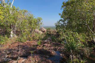
What better way to start exploring our new location than a bush walk to a viewpoint high above Lake Argyle.

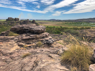
Our walk starts directly opposite the campsite and follows a steep, winding path up the escarpment. Tall, dry grasses line the rocky path with sparse trees and shrubs baking in the heat from the sun. It all feels as if one small spark could set the entire escarpment off in a raging blaze.

Lake Argyle and the Ord River

The effort of the climb is rewarded, though, with magnificent views of the lake and its islands as well as the view back along the Ord River as it flows towards the town of Kununurra. Clumps of bright green grasses dot the hillsides providing contrast to the ancient orange sandstone. And at the head of the river is the Lake Argyle Dam wall. Not huge in the grand scheme of things but impressive in the volume of water the wall is holding back.

To gain a better view of the dam I dropped down from our viewpoint and followed the road down to a lookout just above the dam’s wall and hydro station. From here you get a better view of just how steep the dam walls are and it’s method of construction comprised almost entirely of loose rock and boulders with a compressed core of clay. It’s loose construction was designed to be flexible enough to cope with earthquakes, common in this region of Australia, something that a concrete dam is more prone too. It is especially important in this case as it sits right on top of a fault line and an earthquake in 2016 proved its worth with no damage recorded.

Since construction was completed in 1971 the 98-metre high wall has dropped just 4.5-centimetres due entirely to natural settlement.

Just two-years following completion, heavy rains in the wet season filled the dam to flood level with water pouring from the emergency spillways. They continued to flow through to 1984. In 1996, following concerns of sediment reducing the dam capacity, the spillways were raised by 6-metres doubling the capacity of the lake and plans are in place to increase the level yet further.

Sunset Cruise

Our main trip today, though, was a sunset cruise on the lake, something we had both been looking forward to. Starting from the campsite car park, a coach takes you down and across the dam with a guide explaining the history of the construction project and the attempts at farming in the area. Surprisingly the hydro station was not added until the early 1990’s, 20-years after the dam was completed though provision had been made for it during the original construction.

Freshwater Crocodile

Our cruise aboard the Kimberley Durack took us from Bamboo Creek southwards to an area popular with swimmers. Immediately behind their moored boats was some of Australia’s oldest know rock approximately 1.5-billion years old. That is long before any known life form existed on the planet. The cruise then continued around the headland towards crocodile bay, named after, not surprisingly, one of its many inhabitants.

Crocodiles

The lake is home to somewhere in excess of 35,000 freshwater crocodiles. It seems an excessive number, calculated at night using torches to pick out the reflection of their eyes, but this is a lake of excessive proportions. Measuring 703-square kilometres (271-square miles) and a catchment area forty-six times larger, the lake holds 10,763-billion litres of fresh water. That is the equivalent of 2.5 cubic miles with an outflow capable of supplying the entire country’s annual water needs every 3.5-hours.

Wallaroo and Joey

And not surprisingly, sat sunning themselves in the bay, were several freshwater crocodiles. They are timid creatures with a narrow snout designed to catch fish and pose little threat to people. Our cruise guide, Grant, pointed out that they don’t believe any estuarine (saltwater) crocodiles exist in the lake based mainly on the distance of the inflowing rivers from the sea to the north. But with that volume of water who knows?

The cruise then took us past a distant view of the opencast Argyle diamond mine and towards the lake’s largest island where several unique and well camouflaged wallaroos gathered on the shoreline to feed. One female was carrying a young Joey in her pouch but was quite happy with our presence as we all gathered to take photographs.

Yes, this really is a lake

Further into the lake and the scale really started to show. Right in the very distance were rocks at the eastern edge of the lake – over 20KM away, and that was just one small section of the most northerly region of the lake.

With the sun getting lower in the sky, the cruise moved on to a clear area of the lake where everyone was free to jump in and swim or just float around with a pair of noodles and a glass of wine or stubby of beer in their hands. Below them was 23-metres of clear, mostly crocodile free, water.

Catherine enjoyed a dip where the water was a little warmer than expected but still ‘cool’. As for me, I kept a lookout and helped supply those less wary with drinks and nibbles.

Setting Sun

Finally we started to head back as the sun faded behind the hills and put on a light show worthy of any we’ve seen to date. All we needed were a few more clouds to add colour to the sky, but those, as we’ve found over the last two months, are quite a rarity during the dry season.

Lake Argyle Sunset

It was another great trip and highly recommended. Just remember to bring along your swimmers, thongs, suncream and a can of crocodile repellent spray.

More details at: www.lakeargyle.com-cruises-tours-activities

Litchfield National Park

We have been visiting Litchfield National Park in the Northern Territory this week while staying just outside the park in the small town of Batchelor.

Views are very restricted as you head into the park with thick forest on both sides of the road for many, many kilometres. Only a brief glimpse in a burnt area of woodland gives you any view, indeed any idea where you are. You see, Litchfield N.P. is an enormous forest broken only by a few settlements, stations, gorges and rock escarpments. Without GPS, or a very good sense of direction, it would be very easy to get yourself lost here. There are also very few places to pullover safely even if there was something you wanted to take a closer look at.

Magnetic Termites

Giant termite mound

Our first visit into the park took us past some enormous termite mounds, by far the largest we had seen yet. But nothing could prepare you for those at the ‘Magnetic Termite Mounds’. Here two types of mound were standing tall but very different from each other. The magnetic mounds were being created by a species of termite that can tell where the magnetic north is and the narrow mounds they build align north to south. This means the mound shows the least exposure to the midday sun keeping the mound as cool as possible.

The second form are built like skyscrapers with huge towers and buttresses rising over 5-metres above the dusty grassland. Some, including the so called Cathedral Mound are believed to be over 50-years old and still growing – often taller than the surrounding trees.

Florence Falls

Continuing along we drove to Florence Falls for a hike along Shady Creek walk. From the car park the path quickly leads to the first lookout on a supported gantry overlooking the creek. It’s an impressive view of the Florence Falls even at this time of the year with plenty of water cascading into the plunge pool below. A steep set of steps, all 160 of them, then leads down to the creek through savanna woodland and then the cooler monsoon forest with its shady palms and stream.

Florence Falls

Unfortunately this is yet another beauty spot spoilt by people swimming in the plunge pool so any chance of a decent photograph was out. A very noticeable film of oil was floating on the surface of the water most likely from suncream, which, by the way, contains toxins. Why the National Parks in the Northern Territory encourage this I do not know. Surely the point of National Parks is to protect the fauna and flora for future generations. Allowing suncream to leach into the water is bound to have an affect on fish and other aquatic life and then on those animals that prey on them in turn.

The walk follows the creek upstream for about 500-metres before climbing out of the shade back into the savanna woodlands. From here the walk can then be extended to Buley Rockhole, which is an option we took but it was tough going in the heat with a heavy camera bag strapped to my back.

A few plunge pools lead from the track and I have to admit they did look inviting. We just took a few photographs of the shallow falls feeding the pools and continued on our way to the Rockhole.

A few people were already at the Rockhole by the time we arrived sitting on the rocks spoiling the view for everyone. Here the water tumbles down a few small falls through rocky pools before dropping into a deep pool and disappearing into the wooded creek. It was now getting hotter and there was little shade.

The remainder of the 4.2KM track doubles back following closely by the road to the car park. Waiting for us there was a shaved ice kiosk, which was a great welcome after the heat and sun. You could choose from a dozen flavours, or mix them, but all would be just as refreshing.

Wangi Falls

Our second trip into the park took us 42KM west and close to the park boundary. This was Wangi Falls and was to provide us with the best experience of the park.

Wangi Falls

We arrived early enough to get a shady parking spot, something of a rarity this time of year even though the school holidays in NT were over. Our walk starts from the car park and heads down to the huge plunge pool fed by two high waterfalls from above a vertical rock face. It would be a spectacle during the wet season but was just as impressive now with the rock face in shade and the nearby trees glowing bright green in the sun.

Again the swimmers were present but at least keeping to the shallows near the footpath… for now. Apparently it is a popular spot for freshwater crocodiles too though signs say it is safe to swim. This early in the day the sun is pointing towards you and the contrast and flare make it very hard to photograph. No lens hood or hand waved in the air seemed to help. We decided to try again after our walk once the sun was a little further around.

A boardwalk took us through swampy ground around the edge of the lake to the start of the climb, which winds its way steeply through a mixture of monsoon forest over a steel staircase to a viewing platform. Anyone hoping for a view from the treetops will be disappointed. As seems so often the case in the National Parks of the NT, the trees have grown beyond the viewpoint so all you get to see is trees. Surely there are enough trees around to trim a few and make a viewpoint worthwhile?

Top of Wangi Falls

Eventually the steel steps finish and rock steps continue the climb to the top of the waterfall. Access to the top of the falls is restricted in recognition of an aboriginal ceremonial area. Instead a short boardwalk leads over the streams feeding the falls with a fair view looking over to the distant forested hills.

The path then makes its way to the source of the second fall before heading back down through steep steps passing several small waterfalls along the way until reaching the plunge pool on the opposite side of the upward climb. And as for waiting for the sun to move further around to get a better photograph, we gave up. The pool was now full of people swimming with brightly coloured noodles including directly under the falls. Now, if only there were still a few crocodiles left over from the wet season.

It’s quite a tough walk, especially in the heat, and certainly not suitable for those wearing thongs, as we saw again today, but it is worth it even if you don’t get to see much of a view for all the effort. At least there is a cafe waiting for your return for a much needed coffee and piece of cake.

Drones ‘Permit’ted

Interestingly, the Litchfield N.P allows the use of ‘drones’ by permit holders unlike all the other parks we have visited in the Northern Territory so far. It’s also probably the least likely place you would want to fly one. Obeying CASA rules, you cannot fly over gatherings of people or within 30-metres of anyone. And helicopters are flying pleasure flights low over the falls, which rules out any drone flights.

Darwin Aviation Museum

Being so close to Asia made Darwin the target of the Japanese during the Second World War. The largest single attack on Australia from enemy raiders, more aircraft and more bombs were dropped on Darwin than the surprise Japanese attack on Pearl Harbour. In just one day on February 19th 1942, over 110-tonnes of bombs hammered the city, ships and airbases in two raids in an attempt to prevent Australia’s wartime allies using the region in support of the Pacific War. The raid killed 236, wounded nearly 400, destroyed 30-aircraft and sunk 11-ships at the cost of just 2-Japanese pilots.

The Darwin Aviation Museum has many items from the attack on display including Japanese aircraft wreckage and some rare amateur footage of the attack.

Boeing B-52 Stratofortress

By far the most impressive item on display, by a very long way, is the enormous US Boeing B-52 Bomber around which the museum is built. And I mean around. The wingtips only just clear the museum’s hangar walls and the tail almost touching the pitched roof. This is one enormous eight-engined aircraft.

With a wingspan of 56-metres it dwarfs every other aircraft on display including the huge General Dynamics F-111 supersonic bomber relegated to a corner of the hangar and a 1960’s era Sabre fighter, which sits under the B-52’s tail.

First flown in 1952 the B-52 Stratofortress was the American bomber designed to deliver nuclear payloads during the Cold War as part of SAC – the Strategic Air Command on 24-hour alert with aircraft constantly in the air.

B-52 Vertical stabiliser – 14.5-metres tall

This particular aircraft was recently retired and presented to the City of Darwin as a gift. The B-52 is still in service at bases around the world including Guam and is a regular visitor to Darwin. We were advised one was shortly to takeoff from the airfield behind the museum so we were keeping an ear out for it, not that you were likely to miss the high-pitched whining from its engines on take-off nor the trail of smoke it leaves in its wake.

General Dynamics F-111 Supersonic Bomber

No Barriers

One of the great things about this museum is the lack of barriers. You are free to touch the aircraft, take photographs anywhere and on regular occasions, climb into the cockpits. The F-111 is the only one with a chain fence but that’s more about public safety.

Sadly the cockpits for all the aircraft including the F-111 were closed today but you could still climb up and peer inside at the tiny space the pilots had to fly in. And in complete contrast the B-52’s bomb bay doors were open to view and big enough to swallow two coaches with room to spare.

B-52 Cockpit

The museum houses many early piston and jet engines including the famous Rolls Royce Merlin Engine used in the Spitfire, Mosquito and nearly all the Lancaster Bombers as well as the Rolls Royce Derwent jet engine based on Sir Frank Whittle’s original design, which powered Australia’s first jet powered aircraft – the Gloster Meteor from 1946 to 1963.

There are many more aircraft both large and small to view, helicopters, microlights and a bone yard of sorry looking aircraft outdoors. It’s an interesting place with some unique aircraft and a wealth of information on the Japanese raids on Darwin.

We missed the B-52 take-off but a few days later I saw another B-52 climbing slowly over Darwin through my rearview mirror. Quite a sight.

For more information check: www.darwinaviationmuseum.com.au

Yellow Water Billabong Cruise – Kakadu

Today we’re heading to the wetlands of the Yellow Water Billabong and South Alligator River in search of crocodiles and wading birds. Now it’s a curious name Alligator River, and I have used the correct name, when there are no alligators. It could have been named pretty much anything else, Crocodile River for one but that would have been just too obvious. One possible explanation for this curiosity was an early settler to the region who arrived here from Florida. Another says his boat was called the Alligator. Either way it’s a pretty dumb name.

Australasian Darter

Our cruise started with an excellent guide, Martin, who mixed a good sense of humour with a lot of knowledge and it was very clear he was passionate about this double listed World Heritage site. And almost immediately we were spotting wildlife – catfish swimming past us and Batman spreading his wings. Well, Martin told us it was Batman but I’m pretty confident it was an Australasian Darter spreading its wings to dry in the sun.

Just around the bend of the river and there was Max, a huge male estuarine crocodile basking in the sun getting his blood temperature up ready for another relaxing day. He was so used to cruise boats that we nudged the boat right beside him. He didn’t seem to care. Either he was still too cold to make the effort or he was thinking, ‘just a little closer, come on, just a little more…’

Estuarine ‘Salty’ Crocodile

The cruise continued briefly and then more wildlife – an intermediate egret (great name by the way) magpie geese, another crocodile and another, hundreds of plumed whistling-ducks, a great-billed heron, another egret, a royal spoonbill. And trees too – freshwater mangroves, paperbark and pandanus and a few thousand royal lotus flowers. This place was teaming with life, and that was just above the waterline.

Each time Martin began to explain or describe something there was another creature to see. And everywhere we looked was green, lush and healthy. We were only a few months past the wet season and water levels were still dropping but it was hard to imagine this area ever being under a further two-metres of water and year after year at that. Few trees would ever survive such a soaking but the paperbark tree is one, a true survivor and the pandanus too. It’s no surprise that these are the dominant large trees in the wetlands.

Royal Spoonbill

The wetlands are dominated by grasses and they have a clever way of surviving the deluge of the wet season – they float! What looks like land you could walk on is anything but, step on it and you’ll be looking at fish, long-necked turtles and more likely something with rather large teeth.

More crocodiles basking in the sun and then something a little special, one bird we had been hoping to see – a Jabiru. A huge bird with an enormous black bill. Sadly there’s a problem here. The Jabiru is also a South American bird and the powers to be don’t like two different birds having the same name, so the Australian Jabiru, the one the Kakadu township was named after, has been demoted from the cool names category and is now just known as a black-billed stork.

Jabiru – Black-billed Stork

In the distance was a water buffalo, not a popular animal here any longer – one we saw had recently been shot by Park Rangers and is now being closely guarded by yet another crocodile. Along the edge of the river, clambering over the lily leaves, was a tiny water bird, oblivious to crocodiles close by, with enormous feet, comically large feet, known as a comb-crested jacana. Now that’s a name to be proud of.

And just watching us on the branch of a dead tree was Australia’s second largest bird of prey – the white bellied sea-eagle. A magnificent bird with a massive 2.2-metre wingspan.

Turning around and heading back to the jetty and we were stopping again. There was another Jabiru, a male this time, more crocodiles, more intermediate egrets, lilies, jacanas, whistling kites and magpie geese flying overhead.

White bellied Sea-Eagle

I wasn’t too sure what we would get to see on this trip. There is less bird life than during the wet season but there was more than enough variety, more than we’d seen before in one place, more than we’ll likely see again for a long time.

There was just one large bird that we were hoping to see that we missed – the Brolga. Maybe next time we need to visit during the wet season.

Another great trip and an excellent guide, boat captain and coach driver too. Thank you Martin.

Yellow Water Cruises are run daily by Kakadu Tourism from the Cooinda Lodge. Bookings are highly recommended.

Arnhem Land

Despite all the TV programmes and photographs of Kakadu, I never expected to see so many trees. Not particularly big ones but there are reasons for that and they’re largely to do with bad land management – depending on your point of view. And despite the dry season I hadn’t expected everywhere to be so dry and with such low humidity, which is a bit of a blessing.

Our main adventure is actually just over the Kakadu National Park border. We’re heading into Arnhemland, a magical place rich in both culture and wildlife. We’re doing the Arnhem Lander Cultural and Heritage 4WD Tour with Kakadu Cultural Tours.

River Crossing

The adventure starts as we reach the Border Store on the edge of Kakadu National Park. Here is our first taste of a river crossing on the East Alligator River and we’re certainly at the right time of year in the right type of vehicle. The crossing is a man made weir named after Cahill, one of the early settlers who introduced water buffalo, and shows signs of those a little more confident of their skills and vehicles than they should have been. We saw two large 4WD cars just breaking the surface of the water and there were surely more never to be recovered.

Fortunately our vehicle was a large 4WD truck and the shallow water wasn’t going to claim this one as a victim. Beyond the crossing and we were in a restricted zone, Arnhem Land, an aboriginal reserve and National Park. Almost immediately we were in a different landscape and on a corrugated dirt road certain to dislodge any loose fillings. Trevor, our guide and driver, knew this road well and adjusted the speed to minimise the vibration.

Arnhem Land Escarpment

The landscape varied from open plains of grasses to wooded groves with the type of tree changing as we traveled further. In the distance was the Arnhemland Escarpment, the oldest rock in Australia, so old it contains no forms of fossil of any species including bacteria. At 1,500-million years old it is thought to have formed long before life took hold on this planet. And being comprised of sandstone, it had been a mountain tens of millions of years prior to that before eroding and settling as sand in an estuary.

White man doesn’t listen

During this time Trevor described the modern history of the region and the poor management of the land after the white man took over and introduced water buffalo. Partly for food but mainly for export, the water buffalo trampled the grassland, knocked down small trees and saplings and encouraged weed growth. 

Also introduced was uranium mining in an area known by the local mob as ‘Sickness Land’. They knew from their history that the areas starting to be mined made people ill. They may not have known about radiation from the uranium or the high levels of lead and mercury but they knew it was an area to be avoided. The mines and the buffalo grazing had a devastating effect on the aboriginal people, the animals they relied on for food who’s environment was being changed and the land they had lived on for countless generations, land they cared for and knew how to manage.

Around the time of the Land Rights campaigns, a local elder complained that the land was dying and discussions with the government ultimately led to a compromise – the government would create a National Park to protect the land but only if the aboriginal people agreed to allowing mining to continue with no more than three active mines at any one time. The compromise was agreed but that was the start of more trouble.

White man doesn’t listen… again

It has been known by the aboriginal people that burning the land in a controlled way benefited their food resources but also kept the growth of trees and grasses under control. Burning the spear grass created fresh new growth within days, which attracted wildlife and ultimately food for the people. They knew when to burn and what to burn and created patchwork burns to help prevent wildfires from lightening strikes causing large, hot fires that were too severe for trees to survive and worse, the hot fires also destroyed the seeds of the trees resulting in areas of no tree growth.

Low-level Burn-off

Ignoring the years of knowledge of the local people, the National Parks tried to protect the land rather than manage it. Lack of burns led to dense areas of saplings and combustible leaf litter and dry grasses led to hot fires, which killed not only the saplings but also the larger trees and seeds. Eventually things began to improve when the National Parks began to employ local people and the need for controlled burns was more understood. With the exception of some political parties, the need for controlled burns are well known and are now common practice throughout the country.

Trevor spoke about the paperbark tree as we drove through an area of rich grass and standing water. The tree has some remarkable properties. The bark is both waterproof and fireproof and the sap contains a natural antiseptic. Well known to us as the Tea Tree, the aboriginal people use the bark to make canoes, wrap food before baking in the ground, as a painting surface, for roofing material and as a soft blanket for babies. Being fireproof they can also light fires in their canoes for heating and cooking while out fishing.

Crocodile talk

Our first stop was beside a river where Trevor explained crocodile behaviour and safety. Knowing how crocodiles behave is a major key in being aware when near rivers or where crocodiles may inhabit. And just beside where we stood was evidence a crocodile had been here with telltale tracks in the sand – a male. Male crocodiles climb out of the water and turnaround facing the river prepared for any competing male. They probably get the nicest view too.

Arnhem Land Wetlands

Just a short stroll and we were in open wetland with views over to the ancient Arnhem Land escarpment and water birds, lots of them. Magpie geese, Jabiru, spoonbills… all among brilliant green grasses and flowering lilies. This was the scenery I was expecting. It was beautiful. Not to feel too comfortable in our surroundings, Trevor cautioned us about some of the other wildlife that calls this place home. Australia is well known for its venomous snakes and Arnhem Land and Kakadu are home to most of them. And another less than savoury but entirely man made issue is the Cane Toad, described earlier when we were in Bundaberg. Hundreds of tiny cane toads were just making their way from a small billabong near where we had parked. Fortunately these poisonous little creatures would soon be food for larger animals, including some snakes that have built up a resistance to their toxins.

Our next stop was at the Injalak Arts and Crafts Centre in Oenpelli. Like many aboriginal settlements it was a little rough around the edges with dogs roaming around. But the people were friendly as ever with big smiles. The gallery here is a major source of income and for once the artists weren’t being exploited. Each piece of art is priced in agreement with the artist who receives 97% of the sale price with the remaining 3% going towards gallery and administration costs. Unlike the overpriced artwork sold in the big cities, we were able to purchase at the wholesale price, which gave a very clear indication of the enormous markup galleries charge.

Benson at work at Injalak

We were guided around by Tony and introduced to the artists. It was quite an honour to see the skilled work in action and to be able to talk with the artists about their work and the meaning behind the style of painting. One favourite of ours, Benson, so named after the cigarettes he used to smoke, was extremely good at showing the technique he used and the steady strokes he had developed over 30-years. The painting he was currently working on was likely to take him 3-weeks from start to finish. Looking at the detail and delicate brush strokes it was not hard to understand why.

Examples of some amazing screen printed art, paintings on bark as well as weaving were also there to be seen as the artists worked on them. But then we stepped into the display gallery. It was like walking into another world, a gallery and shop to equal those in any city. The place was full of the work done by the local artists and at reasonable prices.

Craig with our Barramundi painting

We could have spent hours here admiring every piece but our eyes settled on one in particular of a Barramundi and unusual in having a grey background rather than the traditional red ochre. It was painted by local artist Craig and we were advised by the staff that he was somewhere around the gallery and would happily have his photograph taken with the painting. He was too. He took us to a spot with the wetlands and escarpment in the background and produced a big, proud smile for us. We were both very grateful to him and expressed our thanks and admiration for his work. We’ll never forget this experience and have vowed to send him a photograph when we have it mounted and displayed at home.

Lunch followed right next to the Arnhem Land escarpment but a big surprise was in store for us. Part of the tour takes you to see rock art but not like you will see behind protective bars or Perspex in National Parks. Here we were going to see a very special site. Trevor had assessed the fitment level of our group and believed we were up to the challenge of clambering up the escarpment to view some rarely shown rock paintings. This was something we both greatly wanted to see on our trip around Australia and were blown away with what we saw.

Ancient Rock Art – Arnhemland

It was quite a scramble but well worth the effort for the amazing view it provides across the wetlands and the escarpment into the distance. But just behind us beneath and along a rock overhang is some incredible ancient rock art. At least 20,000-years old, many of the paintings looked as if painted recently in amazing detail. Several generations of style were clearly visible including the X-ray style that this region is known for. Trevor explained how the images were created and how they are able to date some of them based upon known animals that have been extinct for thousands of years. Sharks and squid confirm the area once was a sea, kangaroos that no longer live here, barramundi, eels, snakes, echidna, wild pigs and, of course, crocodiles can all be seen here among many of the traditional Dream Time images.

And then it got better with more and older paintings and again at an area few get to see. Here, in intricate detail, were story lines with mother figures, serpents, yam-headed people and many more all described with so much knowledge by Trevor.

Arnhem Land Escarpment

The scramble back down to the truck was just as much fun as the climb but always looking around for anything hiding under the rocks and ledges, anything that might be startled and tempted to bite. We carry a snake and spider bite kit with us when walking in the bush but, of course, being aware of your surroundings and avoiding bites in the first place is always the better option and far less painful.

The rock art was the highlight of today and it is a tour that we cannot recommend highly enough.

More information on the tour can be found at www.kakaduculturaltours.com.au