Today started as our shortest trip so far, probably less than 100-metres. The reason? Our campsite for the past two nights has a delightful cafe serving great coffee. So, once on the road we pulled straight over for a morning brew.
Heading further West
Refreshed, we set-off for our next stop of Longreach in Central West Queensland and even deeper into the Queensland Outback. As we joined the Lansborough Highway we checked the road conditions warning sign. The sign indicates if the roads are open or not and in our case OK with Caution. It’s not that long since the Wet closed many of these roads and it was good to see things had cleared significantly. The Caution warning ahead now related to the condition of the road surface.
What lay ahead of us on this relatively short drive was some of the longest, straightest roads we have seen. And what a change in scenery, dead flat in every direction, anything green has now become a rarity, all grasses are brown, the soil is red and there’s very little sign of life other than the sad sight of roadkill kangaroos. And it was one large roo on the road in the opposite direction that got us onto the VHF radio to warn oncoming traffic. Hitting that would have done some serious damage. Strangely, despite the straight roads they weren’t that flat instead undulating and more so on the floodways that regularly caused the road to dip.
What really surprised us was the number of trees. We’re really into the Western Queensland Outback but it’s not as baron as you might expect. Apart from the occasional road train and an increasing number of caravans, mostly heading east, there was little traffic on the road. What we were seeing more of, though, were the aerobatic Black Kites that fly around the roadsides looking for fresh roadkill.
A Mile of Machinery
The Machinery Mile
Before long we were arriving at the tiny town of Ilfracombe and, like most towns in the outback, there was a reason to stop. The attraction this time was the Great Machinery Mile. It’s actually 1KM long but hey. This unusual collection of historic tractors, diggers, bulldozers, earth movers and carts were all recovered from within a 100-mile radius of town. They show the technological progress from the earliest mechanised machines used as the region was developed since the mid-1800s.
Someone’s legless
Opposite the attraction is the Wellshot pub, a great place for a bite to eat and look around the bar – especially the barstools!
The last short leg brought us to the outback town of Longreach – somewhere I have been wanting to visit for a long time. Longreach is home to the Qantas Founders Museum and you certainly cannot miss it on arrival in town – a 747-800 ‘Jumbo’ jet is sat right next to the road with its six-story high Kangaroo tail towering high above.
So many trees
Just like Barcaldine’s penchant for naming roads after types of tree, Longreach isn’t missing out on the game but has stepped it up a level. All roads are named after birds – waterbirds for east-west and land birds for north-south roads.
Our drive today takes us out of Emerald and 328KM further west into the Central Queensland Outback. We thought we had seen straight roads but these were something else. As far as the eye can see the road continues into the distance.
Termite Territory
This is termite territory and all along the roadside and into the bush are termite mounds and some a little out of the ordinary. It appears a local pastime involves dressing termite mounds as if they are people sitting by the road. Maybe it’s the summer heat or something in the water? At least it gave us something to look at as we drove along.
Soon the trees and termites gave way to open fields and then tree covered mountains as we started the climb into the Drummond Range, which seems to go on forever. Just as we reached a crest another one appeared further on, and then another. A lookout provides a good view back along the range and gives an idea of how high we had already climbed. I also gave us a welcome break from the road and a chance to stretch our legs.
Drummond Range Lookout
Finally reaching the top of the pass and before us a long, long, straight road downhill before levelling out to a flat plain. Gone was the greenery of the mountains to be replaced with dusty dry fields and cattle ranges. The only break in the road being a sweeping bend as we drove into the small town of Alpha and then more straight road before yet another sweeping bend but this time it marks the end of the Great Dividing Range that we have been crossing for many days. To the East of the Great Dividing Range, rain water runs towards the Coral Sea but falling to the West and it winds its way southwest to the seasonal Lake Eyre. Just beyond is the very small town of Jericho and on again, straight ahead for many more kilometres before another sweeping right and left bend for no apparent reason. Maybe the early settlers had drifted off or had a few too many the night before. Either way it helps keep you alert.
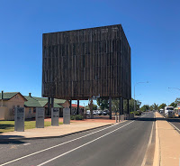
The controversial Cube
The Tree of Knowledge
And finally in the distance was our stop for the next few nights – Barcaldine and what on earth is that beside the road? Called a monstrosity by some and a work of art by others, this is the Tree of Knowledge… or what’s left of it… and then some.
It all began long ago
In 1890 sheep shearers were being divided between union and non-union labour. The union were trying to prevent non-union staff working with those within the union. On January the 5th 1891 union members went on strike demanding protection of wages and workers rights. When non-union shearers continued to work, conflicts began leading almost to civil war in Barcaldine with the strikers taking up arms and building camps surrounding the town. The army was brought in to protect the working shearers and many strikers were arrested – some of who became politicians after release from jail.
The A.L.P
On May the 1st, while the strike was still in effect, a march of union members took place with 1340 men parading through Barcaldine. Within the same month the now penniless and hungry strikers realised the strike had failed. But witness to all the events was the Tree of Knowledge, which became a symbol to the strikers efforts for a fair deal. And from this small town the seed was sown for what is now the Australian Labour Party.
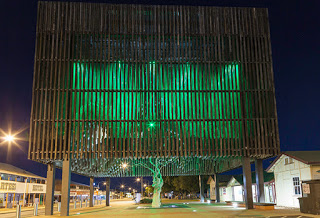
The Tree of Knowledge by night
Having survived for more than a century in the harsh outback conditions, the tree was poisoned in 2006 by an unknown person. The dying tree was removed and sent to Brisbane to be preserved and when it returned, rather than build a simple shelter to protect the tree, the town went into overdrive and what resulted was a $5 million 18-metre square cube. But not just any cube, this one has a glass roof from which 3,600 timer beams have been strung to recreate the tree’s original canopy. Free to move in the breeze they also create a haunting sound. At night the ‘cube’ lights up to represent the green leaves of the canopy. And sat, suspended through a glass panel, are the preserved remains of the tree and its roots lit from below. It’s certainly a curiosity and if you get the chance it’s worth waiting until dark to take a photograph.
It may not be obvious at first but eventually you will catch-on that Barcaldine’s roads are all named after types of tree.
Towns in and around the Gem Fields have produced some interesting name signs displayed as you enter each town. Laser cut from COR-Ten steel and showing topical images for each location, it’s a nice change from the usual sign on a post.
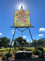
Each town also has some form of unusual attraction for passing visitors. And Emerald has a particularly unusual one – the largest Vincent van Gogh Sunflowers painting in the southern hemisphere… and probably the largest easel too.
Giant Sunflowers
Located behind the Visitors Centre the 7 x 10 metre panel weighs 4.5-tonnes and requires an equally hefty easel to support it. So why a van Gogh? Well, Emerald used to be a major grower of sunflowers and what better and well known sunflowers could there be?
Lake Maraboon
While at Emerald we have been staying at the Lake Maraboon Holiday Village. Not the easiest parking spot for us to access but the staff here know the sites well and without asking will guide you as you reverse park. Very helpful. We were right next to a small section of bush that leads directly down to the lake. Such a contrast to the past few nights with absolutely no noise other than from the wildlife and a few boats heading out on the lake for a day’s fishing.
Meet the Red Claw
Lake Maraboon is well stocked with fish but also has a local speciality – Red Claw. These are a form of fresh water crayfish often called yabbies and they thrive here. Of course we couldn’t leave Lake Maraboon behind without trying some Red Claw for ourselves in the form of the speciality pizza at the Holiday Village restaurant. And what does it taste like? Delicious!
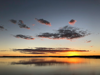
Lake Maraboon Sunset
The lake forms the Fairbairn Dam, which is the second largest lake in Queensland, except right now it is in trouble. With very little rainfall during the summer the water level is now at its lowest since the dam was constructed in 1947. As a result wildflowers have grown on the banks that would otherwise be submerged by several metres of water. It is so low that the water no longer reaches the dam wall. By contrast, the floods of 2010/2011 saw the dam at 176% capacity resulting in a wall of water 5.5-metres high running over the spillways. The dam owners are currently taking advantage of the water level and performing some major repair work to the dam walls.
The lake also provides some great photo opportunities with many varieties of water birds both seasonal and local and ideally positioned for sunrise and sunset photographs. Unfortunately that also means contending with the flies and mosquitoes.
Heading West
Today is our last day in Central Queensland and we’ll be making our way further into the Queensland Outback towards the town of Barcaldine, which has its own very unusual attraction.
Today we’re about to do something on our list of adventures. We’re going to strike it rich in the Outback Gem Fields!
Australia has many mines and is well known as a major producer of coal, copper, gold, uranium and opal. Lesser known, though, are the extensive gem fields and one of the biggest is right here in Central Queensland.
We’re currently in Emerald and you’d expect the town to be named after, well, Emeralds surely. Sadly that’s not the case but the neighbouring townships, or rather settlements, of Sapphire and Rubyvale are more descriptive of their origins… or are they? Things are not quite what they seem out here.
There’s Anakie out here
Anakie Statue
The gateway to the Gem Fields is via a township called Anakie. Or rather the crossroads at Anakie where a sculpture has been erected with coloured elements to represent the multitude of colours that the gems here take on.
Just to the north is Sapphire and for once it bears the name of what can be found here. First discovered in a creek in the 1870’s, high quality sapphire gems have been mined here ever since. And here too in the Gem Fields are seven sites that the Australian Government have allocated for treasure hunters to try their luck at fossicking for valuable gems. All that is required is a license, a spade, a filter, water and time – as much as you can bear in the blazing summer heat.
Formed in Volcanoes
A cooling process deep within a volcano allows the minerals that produce gems to crystallise. Then, over a period of millions of years, the volcano is eroded by the elements depositing the hard crystals in a sand/pebble mixture known as ‘wash’. In places the wash is exposed in creeks, as was the case with the first sapphire discovery, but mostly the wash is buried by subsequent rock erosion and the only way to access the gems is to dig.
Sapphire and its surrounds are peppered with mounds of dirt from claims that have been mined and the process is still continuing today. Anyone can stake a claim to mine on a commercial basis – if you have the money. A license, a bore drill, washing machinery, mining tools, your white claim marker post and a large pair of brave trousers are required. And the only way to determine if you are going to find anything is to drill a narrow bore hole and look at the dirt spoil for telltale signs of the ‘wash’. Once you find it it’s time to climb down the bore hole and start digging outwards.
Many of the miners make a living from selling cut stones from their mines and there are many shops along the road through Sapphire to explore. We had read of a ‘walk-in’ mine open to visitors in the next township of Rubyvale. But first, time for a coffee.
If you are ever in the area drop by Muggachinno’s cafe on Keilambete Road. It is a little green oasis of treasures serving Merlo coffee with a side measure of port and the best Austrian cherry strudel this side of Austria.
Miners Heritage Walk-in Mine
The Miners Heritage mine provides easy access tours around a once active sapphire mine. Originally opened as a tourists and working mine, successive governments and red tape have restricted the mine to tourists only for ‘safety reasons’. On a positive note it means the mine tunnels are big enough to walk through without being on your hands and knees like the miners.
The guided tours are a must and the knowledgeable guides will take you down to a depth of 17-metres along a dusty path beside the crumbling tunnel walls. Don’t be alarmed though, the tunnels are regularly inspected and, as the guides say, if it wasn’t safe they wouldn’t be in the mine themselves.
Sifting the Wash
Several tunnel offshoots show rough sapphires that are still embedded in the wash and the guides point these out as well as some less obvious ones. A short video explains the process of mining through to a polished gem. So much work and no guarantee of finding anything at the end of it. But it’s the chance of the next bucket bearing your retirement fund that keeps you going.
The tour takes in 400-metres of the mine altogether at a depth of 17-metres, which doesn’t seem that deep until you take a look up one of the original bore shafts. And at the end of the tour a visit to the gem shop may tempt you to buy a piece of jewellery for your loved one or a gem stone to set in your own design. We bought a bag of dirt instead. Not that that is a bad thing. It is guaranteed to contain a cut gem and the possibility of many more sapphires or zircons… but you have to work for it.
Sorting the Wash
Outside the mine is an area set aside for fossicking – the process of extracting gemstones from the wash. We were shown how to filter out the larger waste rubble and then wash the remaining smaller stones, much like gold panning, before tipping the remaining stones onto a drying bed. Here we manually pick through the hundreds of small stones looking for the ones that shine. And after a few minutes we started finding them. We’re rich!! In all we had found 17 rough sapphires of various colours and four zircons. Total value? Well, nothing really but it was great fun.
Where are the Rubys?
Well, as mentioned, not is all as it would seem. The first discoveries at Rubyvale later turned out to be red zircons and not rubys as originally thought. And would you really want to call a place Zirconville?
The Black Star of Queensland
The world’s largest Black Star sapphire, the Black Star of Queensland, was discovered right here in Rubyvale by 12-year old Roy Spencer in 1938 who noticed the interesting black crystal in a pile of wash that had already been examined. He showed the crystal to his father, a pioneering miner in the gem fields, who dismissed it as just a black crystal of no value. It spent the next decade as a doorstop before Mr Spencer, the father, realised sapphires could indeed be black and worth a fortune. It weighed 1,156 carats. It was sold in 1947 for the then princely sum of $18,000 dollars and made its way to America. It was then cut and polished and valued just two years later at $1-million dollars. The Star of Queensland was recently offered for sale with a reserve price of $88-million dollars.
Something strange is going on on the beaches. Millions and millions of tiny balls of sand are appearing on the beaches on each turn of the tide. We’ve seen lots of these balls along the beaches of Sydney but in Yeppoon things are on an altogether grander scale.
Crab Sand Balls
Here on Farnborough Beach at Yeppoon extending 17km long and approximately 200-metres wide, these tiny sand balls are taking over the beach. And what is creating them? Sand crabs. Now just think of the scale of this. The crabs are tiny at around 1.5cm across. When the tide goes out the crabs tunnel up to the surface of the beach collecting sand on the way, forming them into tiny balls and depositing them in an organised pattern around their tunnel. Four sand balls just fit into one square centimetre. The area of the beach entirely covered is approximately 3.4 million square metres, which means these incredibly industrious crabs are creating 13,600,000,000 sand balls twice a day, day after day after day only to get washed away with the next tide.
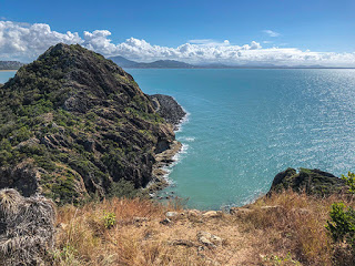
Double Head National Park
Adjacent to Keppel Bay Marina is Double Head National Park, which, as its name suggests, has two peaks reaching out into the sea. Of the two, Fan Hill is the easiest to access with great lookouts on the way up the steep track and from the top looking in all directions. Both hills are the remnants of volcanic activity in the area and are comprised of hexagonal columns of basalt bent and twisted over the years.
Fan Hill – Looking North
Even if you are not interested in the geology of the region, a walk to the top is definitely worth the effort for the views alone, and at the time we were here in June you’ll be surrounded by butterflies and moths. Access to the walk is from the right of the marina. A new car park is being constructed and the walk starts to the left of the new car park.
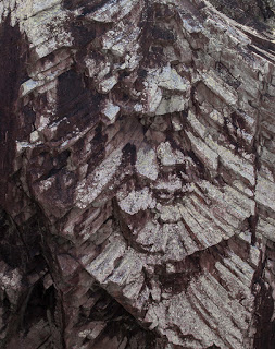
The name Fan Hill originates from the shape of the rock formation visible at the first lookout of the walk.
Fan Hill – Lava formation
Though it may not be too clear from the photograph of the lava formation, a central column of magma broke its way through the earth’s crust and radiated outwards. The lava cooled slowly and eventual cracked into the hexagonal patterns we see today. Where it is now exposed at the lookout a fan shape has formed where the surrounding rock has eroded or broken free.
Blueberry Pancakes We had spotted a nice looking cafe as we drove along the Yeppoon seafront yesterday and decided to give it a try. Called Lure Living, the cafe is a relaxing place to spend a couple of hours especially for breakfast where the best Blueberry Pancakes I’ve ever tasted can be savoured. I’m not sure how they make them so light and fluffy but they are very highly recommended. The coffee is pretty good too. One thing to note though, in Yeppoon most places close early so get your orders in before 2pm or you will be disappointed.
We’d also highly recommend ‘Flour’ cafe on the main street for excellent salads, quiches, cakes to die for and Toby’s Estate coffee. BBQ Pizza
Having cooked our first steaks on our Weber Baby Q recently, which were a revelation, we decided to give the Pizza stone a try. We normally use Lebanese flatbread for pizzas at home but they’re too large for the mini Weber. Instead we bought a pre-made pizza bread thin base made by Bazaar, which fitted the pizza stone perfectly. And what a great pizza the Weber makes. It takes almost twice as long as our home oven and doesn’t quite melt the cheese as much but it produces an excellent crisp base without drying-out the tomato paste.
We’ll be trying our own pancakes soon but first a long walk along Farnborough Beach to walk-off some of our recent treats.