I have to admit, being from the UK, I’d never heard of Bert Hinkler but the more I discovered today at the Hinkler Hall of Aviation the more I was surprised his name is not better known outside of Australia and Italy.
Born in Bundaberg in 1892, Herbert John Louis Hinkler worked briefly in the sugar mills and foundry at Bundaberg but his real passion lay in aviation, which, despite its dangers, had been actively encouraged by his mother from an early age. He took a correspondence course in mechanics giving him the grounding he needed to build his own aircraft.
Hinkler Hall of Aviation
Bert built two gliders, the second of which was based on his personal study of the Ibis, a common long-billed bird here in Australia. This led to his first successful flight from the beach now called Mon Repos, just 7KM from our site of Bargara. This short flight was the first recorded manned flight of an aircraft in Australia.
In 1913 Bert moved to England and found work with Sopworth Aircraft who had just started to build biplanes for military use. Shortly after he joined the Royal Naval Air Service. From his service with the Navy, where he first learnt to fly powered aircraft, he soon transferred to the Royal Airforce and was stationed in Italy for the remainder of the First World War. In February 1928 Bert made the first solo flight from England to Australia in just 16-days and breaking five aviation records on the way.
Following years saw Bert as a leading test pilot in England working for an experimental division of A.V. Roe, manufacturer of the famous Lancaster Bomber, before moving to Canada where he began planning a light aircraft flight around the world. In the meantime he attempted a second England to Australia flight leaving Heathrow during the Winter of 1933. It is believed mechanical failure or bad weather resulted in a crash in the Appenine mountains of Italy. He survived the initial impact but died shortly after at the scene. His body wasn’t discovered until the Spring during the snow melt. He was buried in Florence with full military honours on the order of Mussolini.
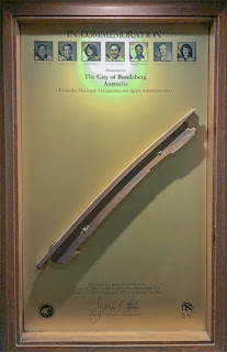
Space Shuttle Survivor
He received numerous medals, awards and prizes during his flying career but the thing that really amazed me was an event that took place on January the 28th 1986, long after his death.
Space Shuttle Challenger
You may wonder what NASA’s Space Shuttle has to do with our Mr Hinkler. It is a little convoluted but stick with me. The Hinkler House Memorial Museum and Research Association invites guest speakers to present a lecture to the Association’s members. In 1985 one such speaker was NASA Astronaut Don Lind, having just flown as Mission Specialist and Payload Commander on Space Shuttle Challenger flight STS-51-B. As a thanks for the lecture the Association presented Don with a small wooden section of wing spar from Bert’s 1911 glider.
Now, Don Lind was a friend of fellow Astronaut, Shuttle Pilot and later Shuttle Commander, Dick Scobee. As Dick was due to fly as Shuttle Commander the following January on flight STS-51-L, Don had asked Dick to carry the glider fragment into space to honour the memory of Bert Hinkler’s aviation achievements and contribution to human flight. As fate had it, flight STS-51-L was launched with the knowledge that the icy conditions were unprecedented and may cause issues with the gas seals on the solid rocket boosters. Lind, on his first and only space flight, and Scobee, had flown previously on Challenger but this flight, Scobee’s second, was to end in tragedy. Just 73-seconds after lift-off, Challenger suffered a catastrophic failure exploding 46,000ft above the South Atlantic Ocean. None of the seven crew onboard survived. The fragment of Bert’s glider never made it into space. But that wasn’t the end of the story.
A Survivor
Incredibly, the fragment of glider survived the explosion and was discovered among the 15-tons of wreckage recovered from the ocean. In 1987 Dr June Scobee, Dick Scobee’s wife, visited Australia on behalf of NASA and presented the mounted fragment of Bert’s glider to the Association from where it began. It is now on display at the Hinkler Hall of Aviation in Bundaberg.
Bert’s UK House – in Bundaberg
Bert Hinkler’s name lives on in aviation having his name carried on one of Qantas’ Airbus A380 aircraft. In fact so strong is Queensland’s admiration for Mr Hinkler that his entire UK house was demolished brick by brick and transported half way around the world and rebuilt in the Bundaberg Botanic Gardens where the Hinkler Hall of Aviation now stands.
Regarding the house relocation, I have to confess, this one puzzles me.
We had an easy 343km drive from Hervey Bay to our new base at Bargara Beach near the town of Bundaberg.
Bundaberg
For anyone with a taste for Rum, Bundaberg is a very well known name – being the Rum brewing capitol of Australia and the name on every bottle. And there is a very good reason for its location – Bundaberg is surrounded by sugar cane fields. But the origin of rum at Bundaberg goes back to 1888 when the distillery began operating. It started as a means to make use of the waste product of sugar production – molasses. Too heavy and expensive to transport efficiently and texpensive to convert to cattle feed, the idea of distilling molasses was seen as a profitable way to reduce waste.
Why the Polar Bear?
In 1961 an advertising campaign launched Bundy R Bear, the Bundaberg Polar Bear, to market to a younger audience and a claim that Bundaberg Rum would ‘ward off the coldest chill’. It’s still appearing in commercials today.
We have a leak
We noticed a small water leak in our Jayco caravan recently, which has resulted in a small area of laminate panel rippling. Annoyingly the leak is something that Jayco clearly knew about during manufacture. The leak is from a cold water joint leading to the outdoor shower, which has made the panel under the fridge warp enough to prevent the adjacent door from closing. At some point Jayco reseated the door but didn’t fix the cause of the leak. It’s in a difficult location in a tight space. Tightening the joint made no difference. I fitted a temporary stop connector so we could still use water in the caravan until we can get a permanent fix. Fortunately Jayco Bundaberg were able to book us in at short notice before we headed further north. Many thanks to the great team there for a job well done under warranty.
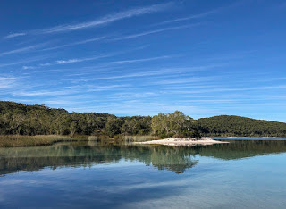
Bargara Beach
Our new location at Bargara Beach Caravan Site is a very short stroll to the expansive beach and just a 10-minute walk to the local shops and restaurants. It has plenty to entertain the young ones with a play park between the caravan site and the beach, tennis courts for the oldies and access to a playing field and running track for those with a little more energy to burn-off. Walking tracks lead to Mon Repos, a world famous Turtle beach where turtles return each year to lay their eggs beginning in November with the young making their way to the sea until the end of March. Mon Repos has the highest concentration of egg laying turtles on the whole of the eastern seaboard of Australia. If you find yourself here during that time, make sure to visit the Mon Repos Turtle Centre.
Ready for planting
Sugar Cane
Sugar cane is one of the main crops grown in the region and is highly visible as a tall, broad cane growing right to the roadside of many of the local roads. Of particular note is the amazing colour of the soils in the area. Much of the region was formed by long extinct volcanoes that have since weathered down leaving a very fertile, rich orange-brown loam.
Newly planted fields are a photographer’s dream with long, straight lines leading to the horizon. I was lucky to capture a shot just after fertiliser had been added to the soil leaving distinct white lines in the tractor treads.
One repeatedly frustrating thing any photographer will find, not just in this region but also central and northern NSW, is the lack of places to pull off the road to take photographs. Largely this is due to the narrow borders to the side of the road and the often steep drop-off into drainage ditches. The solution is often a good walk from a safe place to park as was the case in the adjacent photograph. At least in late Autumn it’s not too hot or humid here in South East Queensland.
Recently planted Sugar Cane
Cane Toads Two pests affecting sugar cane production in Queensland, and now further afield, are the native and French cane beetle. In 1935 the Bureau of Sugar Experiment Stations hit on the ‘brilliant idea’ of introducing the Hawaiian cane toad to Australia. This particular toad has a veracious appetite for sugar cane beetles. And, of course, the cane toads did what comes naturally, eat and multiply. Unfortunately lessons weren’t learnt from the disastrous introduction of rabbits, foxes, cats…etc to Australia and now the spread of the cane toad has got out of control with the species reaching many places in New South Wales, the Northern Territory and Western Australia. Worse still the cane toad is poisonous and is taking its toll on many forms of native wildlife that happens to like the taste of frogs and toads. One such creature is the Death Adder snake where the cane toad is believed to be responsible for an 85% decline in this species. The toxin excreted by the cane toad is fatal to most snakes but recent research suggests that some species are developing avoidance behaviour in areas where the toad is well established, red-bellied black snakes in particular. Similar observations have been noted with young fish avoiding the cane toad tadpole, which is equally toxic.
Cane Field Fires
Towering Sugar Cane – Ready for harvest
For many years farmers burned their sugar cane fields to get rid of the dry leaves at the base of the plant. This made cutting the cane by hand easier but at the same time resulted in many native animals being killed in the fire including the Death Adder (poor thing’s not having much luck here), the coastal taipan, pythons and the red-bellied black snake. There will be those that say good riddens to snakes but they also control the small mammal population of rats and bandicoots.
Much to the relief of the wildlife I’m sure, harvesting is now done on an industrial scale with machinery and people are kept clear of anything that is likely to bite if trodden on. Attempts at controlling the spread of the toad have been far from successful and now more research into the creature is taking place to find other methods of control. In the meantime it is down to hand collecting and giving them something to, er, help them sleep.
Kalki Moon
Although, as mentioned, Bundaberg is famous for its Rum, a new tipple is brewing in town. Former Bundaberg brewer Rick Prosser and his family started the Kalki Moon Distillery in 2017 and have gone on to receive numerous awards including beating the British at the own game with their excellent Kalki Moon Gin.
The distillery is still small but their aim is to produce quality over quantity and we can certainly vouch for that – it is very smooth. Especially important is the Australian botanicals used in the brewing process. Apart from the required juniper berry, Kalki Moon Gin adds lemon and cinnamon myrtle, ginger and native finger lime. Certainly one distillery to keep an eye on.
Bargara Beach Sunset
And what can be better than happy hour with a G&T as the sun sets over the horizon.
Today was an early start rising with the sun at 6am. A new adventure awaits us on Fraser Island, the world’s largest sand island, just off the coast of Hervey Bay.
Peter from Fraser Island Explorer Tours picked us up along with five others and took us to the ferry terminal at River Heads. Forty-five minutes later and were boarding our 4WD tour bus and heading on the rough sand road to Central Station approximately half way across the island.
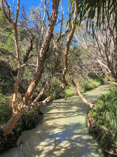
Wanggoolba Creek
The name, Central Station, is a little misleading giving the impression of a transport hub but it is anything but. Originally an early settlement for loggers it quickly grew adding a school for growing families. Now little remains of the settlement but it is still home to some amazing trees, Kouri’s, Satinay and Hoop Pine rising perfectly straight towards the sky. We took a short but visually stunning walk from here to Wanggoolba Creek with its crystal clear water trickling under the shade of the trees and ferns, some that were around during the age of the dinosaurs. We were also treated to the early bird song, which was the only thing that broke the silence of this beautiful place.
As we drove across the island there were very distinct changes to the native vegetation. From the west are the large trees and dense scrub but as the landscape becomes increasingly exposed to the salt air from the prevailing south-easterly winds, the trees become smaller, ferns and bracken become more common and eventually grasses, low scrub and banksias take over as we reached the coast.
The Road!
Visitors to the island will very quickly realise this is the domain of 4WD cars and ones with very strong suspension and low tyre pressures to handle the very rough sand tracks. It was far rougher than either of us had expected and apparently the tracks were in pretty good condition right now. Our 4WD bus was designed to handle this kind of punishment being raised high off the ground and equipped with independent suspension but it was still very rough at times. The wearing of seat belts is compulsory and with very good reason.
Our 4WD Transport
Once we had reached the east coast at Eurong we headed north on the beach highway of 75-Mile Beach. It’s an amazing location with crashing waves to our right, bush to our left and a sand beach as far as you can see in front and then much further again. It’s a policed ‘road’ with a maximum 80-KMH limit and where normal road rules apply, so don’t be surprised by a random breath test.
We weaved around the firm sand, surf, dips and rocks along with several other 4WD vehicles passing in both directions, mostly on the correct side. And where the tide, deep creek or rocks blocked our way we cut inland over some pretty steep tracks.
Bingo a Dingo!
Pete had been talking to us about the infamous Dingo native to Fraser Island and especially the idiots who, despite all the warning signs, feed them scraps so they can stroke them or have their photo taken with them. These are not pets, they aren’t even dogs as we know them – though they look much like them. These are wild, highly intelligent and often dangerous animals that with the temptation of food may attack. Perhaps worse still, they will get accustomed to being fed and will lose any fear of humans thereby posing a greater danger to us and often leading to the animal’s destruction.
Dingo!
And right on queue, there was a Dingo walking along the beach. Pete circled the bus so we could all take a photograph from a safe distance.
Up a Creek but no paddle
Further up the coast was our first stop at a spot called Eli Creek. The creek is one of many that fresh filtered water bubbles up from the underground aquifer and onto the beach but this one is particularly gushing with 4-million litres of pure, fresh water heading out to sea every hour. A boardwalk has been constructed so you can walk along the creek and then float back in the current or paddle back to the beach. It was a little chilly in the shade this morning so a quick digit test of the water and a photo had to suffice. During the high season, apparently, it’s crowded here with often 6-coach loads of tourists all wanting a dip. We were lucky being late in the season, it was almost deserted.
Eli Creek
It was time for a morning cuppa and Pete had prepared drinks and pastries for us including what looked like a ghost shaped chocolate chip biscuit. I was corrected, held the right way up it was a Dingo’s footprint. Hopefully the dark bits really were chocolate. Either way, they were delicious.
Fancy a Flight?
Just as we boarded the bus we saw two light aircraft that had just landed on the beach. Fraser Island is one of only two licensed commercial beach flight operations in the world, the other being Barra in the Outer Hebrides off the West coast of Scotland. Pete took us over to one of the pilots to give us a chat about the flights they run over the island. Catherine was immediately hooked and so were the rest of us, all seven of our tour. Within 15-minutes we were racing down the beach and up into the air on an unexpected extra adventure.
On the Runway
It was a small light aircraft with just 8-seats including our pilot, which gives a truer flying experience than a commercial airliner complete with tight turns, engine noise and quicker manoeuvres. Similar to my first flight in a 4-seat Piper Cherokee, almost as soon as you take-off there is very little sense of forward motion and you feel as if you are just hanging there.
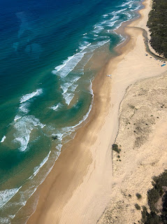
Our flight climbed to 1500ft and turned briefly over the sea looking for any dolphins, turtles, manta rays, stingrays or whales, which were just starting to pass Hervey Bay on their annual migration. Nothing this time so we turned inland over the enormous forests with a clear view of the whole island, all 123-KM of it from north to south and 22-KM east to west. Then, turning again to fly over several of the perched lakes, remote 4WD tracks and sand dunes. And back over to the sea again banking steeply side to side looking for wildlife in the crystal clear water.
The runway and Eli Creek
A dolphin and sting rays were spotted on Catherine’s side but nothing from where I sat. We also did a pass over the Maheno shipwreck that we would soon be seeing at ground level. Finally one last circle over the sea before lining up for a smooth landing on the beach a little further north at the Pinnacles, which was our next intended stop where Pete was already waiting with our Bus. A great experience and absolutely recommended to see the island from a different angle.
The Pinnacles
These multi-coloured sand cliffs have been eroded over time to create pinnacle like sculptures. It is a place of significance for the local Aboriginal mob as a women’s place and the elders ask that you don’t walk too close or climb any of the structures. This is something that we strongly respect and is surely the best way to preserve what is here. Sadly not everyone feels the same way. The same ‘no climb’ policy at Uluru was requested and is now compulsory. We had both climbed Uluru in 2000, an amazing experience, but not something we would do again out of respect… and it’s a tough climb too!
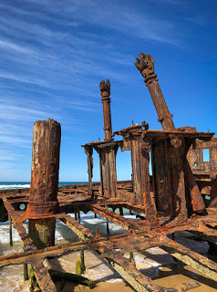
Maheno Shipwreck
We had perfect weather and a good tide for our next stop as we headed back south to the SS Maheno shipwreck. This huge rusting wreck looks spectacular against the deep blue sky offering countless photographic opportunities. Again, being out of season helped with few people around other than ourselves. It would have been great to have taken a photograph with the drone but it was quite windy and our time here was limited.
The Maheno
The ship has an interesting history starting out as an ocean liner operating between Australia and New Zealand from 1905 to 1935-years. During the First World War she served as a Hospital Ship before being swept ashore during a cyclone in 1935. Strangely the Australian Defence department list the wreck as a site of unexploded ordnance though nothing has ever been found here. There are stories, however, that the Japanese bought the ship to recover valuable metals before trying to tow it offshore and that Australian aircraft had bombed the ship to prevent it falling into enemy hands as Japan aggressively expanded its operations in the Pacific.
Back down the coast to Eurong for a lovely lunch before a very rough drive to Lake McKenzie. Now when I say the road is very rough that is perhaps an understatement. There is no way I would want to drive a vehicle smaller than ours with its high clearance and independent suspension, even the driver’s cab is isolated from the body of the bus where we sat.
High traffic to this popular spot has created large holes, ridges and gullies and the National Park want to keep it this way! They say there isn’t enough sand to fill the holes. Really? On the world’s largest sand island? Where do they think the sand has gone that once filled the holes? However, there is ‘some’ logic to this. Improving the road could lead to easier access and encourage more visitors. It could even attract vehicles that aren’t true 4WDs and cause all sorts of road damage and blockages on the single track roads.
Lake McKenzie
Lake McKenzie
But, bad road apart, Lake McKenzie is absolutely worth the visit… out of season when it’s not crowded. The enormous fresh water lake is only here because decaying vegetation has settled on the lake bed and gradually worked its way through the fine sand to form a firm, water retaining rock-like layer know as coffee rock. It is the sand, though, that makes this place special. Each grain of powder fine, white sand is round rather than the normal irregular shaped beach sand. It not only makes it look whiter it is also fine enough to use as a polish, though I wouldn’t want to try it on anything valuable.
Popular with swimmers, it was a little cool today with a breeze coming off the sea but I could imagine a dip here during summer would be amazing. Still, the temperature didn’t put-off a group of younger visitors that arrived before us.
Waiting for the ferry
At least the return drive to the ferry wasn’t quite as rough and waiting for us was a courtesy drink at the Sunset Bar of the Kingfisher Resort. A perfect ending as we watched the sun setting over the mainland and a coffee to take on to the ferry.
A great experience, beautiful weather, a great tour guide, stunning scenery and the unexpected flight. Worth every cent. And to think we were hesitating whether to visit the island or not.
Maryborough, sitting on the Mary River, is a sizeable historic town about 40KM from our base at Urangan, Hervey Bay. We passed through here on our way north from Coolum Beach and had planned a visit to find out more about its claim to fame, a somewhat unexpected and surprising one.
You cannot fail to spot the many typical Queenslander style houses that line the roads approaching the town centre. It’s great to see so many in such a good state of repair especially given their age and the weather they have to survive here every year.
Troubled Past Sadly, Maryborough has a troubled early history with the local aboriginal tribes being mass poisoned twice and the following skirmishes resulting in many deaths on both sides as settlers moved further into aboriginal land. Further deaths followed in 1905 when Australia’s only outbreak of pneumonic plague killed ten people all linked to the same house in town. Fear took hold in the community, which led to the property being set alight and destroyed. Fortunately the cause of the disease was identified and contained but not before two nurses died while aiding the first cases. They were subsequently honoured with a memorial fountain being erected in the grounds of the City Hall.
Mary Poppins – Australian Roots
P.L. Travers
Maryborough has a close tie with the children’s storybook character, Mary Poppins, and it makes the most of the link, and a tenuous one at that, if you know where to look.
Author P.L. Travers, born Helen Lyndon Goff, came into the world on the second floor of the bank building on the corner of Kent and Richmond Street in 1899. But Helen and her family moved away from Maryborough when she was only 5-years old. Two years later the family again moved, this time to New South Wales following the death of her father. In 1924 she emigrated to England where she took on the pen name of Pamela Lyndon Travers and, following a further move, she settled in Sussex where in the Winter of 1933 she began to write the story of Mary Poppins. So, a very tenuous link indeed.
In 2005 a life-size bronze statue of P.L. Travers was erected next to her birth place, and anyone standing beside her will realise she was tiny and looked very much like the Mary Poppins pictured in the 1964 version of the Disney film – complete with umbrella.
A nice touch in town, at each pedestrian crossing, is Mary Poppins featured in each crossing light. A great way to get children to pay attention.
Instructions too for visitors not familiar with the story or the all important Poppins magic umbrella. All this has got me thinking… what else of Australian origin or fame could be used at pedestrian crossings in other towns and cities. Come on councils, be creative.
First of all, Hervey Bay is just that – a bay, or rather a coastal bay. It’s name is well enough known but should be thought of more as a region than a destination. The coastal region comprises three beachside neighbourhoods; Urangan to the east and nearest to Fraser Island, Torquay in the middle and Scarness to the west. There’s little to separate each with beachfront houses and motels linking them together.
We are staying at the Pier Caravan Site in Urangan. It’s a new site with very modern facilities and a number of 45-degree slabs and driveways making reverse parking much easier. The only downside, there is no shade – at least until the newly planted trees have grown tall enough. It’ll be more of an issue in the summer but fine for the rest of the year. You also feel as though you are in suburbia with the site surrounded by houses.
Urangan Pier – All 868-metres of it
Urangan, incidentally the Aboriginal name for a dugong*, is home to an enormous pier, which provided deep water access to what is otherwise a very shallow bay for freight and produce being sent by rail to and from nearby Maryborough. Sadly no longer used for freight and at one stage being demolished, local residents campaigned to save the pier – well most of it. Originally reaching 1.1KM out to sea but only 868-metres remains. That’s still huge and a good return walk at the start of the day to watch the sunrise over Fraser Island and again at the end of the day to watch the sunset in the west.
Another popular walk is the 17KM beachfront Esplanade. Ideal on a sunny day with many trees providing shelter and pleasantly warm in the winter.
Hervey Bay is probably best known for its whale sightings, regarded as the best place in the world to watch Humpback whales. The humpbacks rest and play in the bay for a few days at a time as they head from the Antarctic to their breeding and birthing grounds of the Great Barrier Reef. The whales appear along most of the east coast of Australia and Hervey Bay in particular between July and October. The timing of our trip means we’ll most likely miss the whales but at least the temperature will be more comfortable and much lower humidity… and we can always return!
One of the main reasons for visiting Hervey Bay, though, is to explore Fraser Island, the world’s largest sand island and the only one with a rainforest. And that’s where we are heading next.
Dugong – for our international friends a Dugong, also known as a sea cow, is a large ocean living mammal with front fins or paddles used like legs and a large fluke tail, similar to that of a whale. Partial to sea grass the Dugong is found mostly in shallow tropical and subtropical waters where it has easy access to food, which it eats with its huge, cow-like mouth.